

- Forecast
- Maps
- Live
- Weather State
- Spot Information
Arinaga Surf Forecast
/ Gran Canaria (26 surf breaks) /
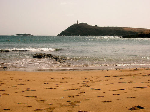
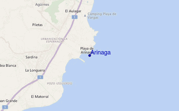
Arinaga surf Forecast / Gran Canaria / Spain
- Map Icons:
 Break
Break Live Wave Height (m)
 Live Wind Speed (km/h)
 Surf Rating (10 Max)
 Ocean Swells (m)
- Wind Speed (km/h)
How big are the waves at Arinaga today?
The current surf forecast for Arinaga at 12PM is: 1.1m 10s primary swell from a North direction and 0.5m 12s secondary swell from a North direction (forecast issued at 06:00am April 19). An open ocean swell of 0.6m 4s is not directed at the surf break. The wind direction is predicted to be cross-shore.
| Time (WEST) & Date | Wave Height | Wave Period |
|---|---|---|
| Morning (19 Apr) | 3.5ft (1.1m) | 10s |
| Afternoon (19 Apr) | 3.5ft (1.0m) | 10s |
| Evening (19 Apr) | 2.5ft (0.8m) | 9s |
Table - waves today at Arinaga. (Swell directed towards the surf break)
Friday 19 | Saturday 20 | Sunday 21 | Monday 22 | Tuesday 23 | Wednesday 24 | Thursday 25 | Friday 26 | |||||||||||||||||||||||||||||||||||||||||||||||||||||
| 4 AM | 7 AM | 10 AM | 1 PM | 4 PM | 7 PM | 10 PM | 1 AM | 4 AM | 7 AM | 10 AM | 1 PM | 4 PM | 7 PM | 10 PM | 1 AM | 4 AM | 7 AM | 10 AM | 1 PM | 4 PM | 7 PM | 10 PM | 1 AM | 4 AM | 7 AM | 10 AM | 1 PM | 4 PM | 7 PM | 10 PM | 1 AM | 4 AM | 7 AM | 10 AM | 1 PM | 4 PM | 7 PM | 10 PM | 1 AM | 4 AM | 7 AM | 10 AM | 1 PM | 4 PM | 7 PM | 10 PM | 1 AM | 4 AM | 7 AM | 10 AM | 1 PM | 4 PM | 7 PM | 10 PM | 1 AM | 4 AM | 7 AM | 10 AM | 1 PM | |
Rating (10 max) | ||||||||||||||||||||||||||||||||||||||||||||||||||||||||||||
Swell Height Map |    |  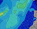 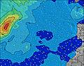 |  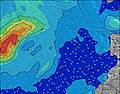  |   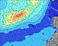 | 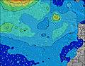 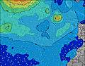 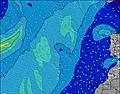 | 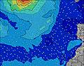 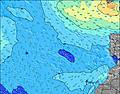 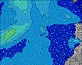 | 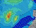 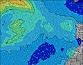 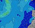 | 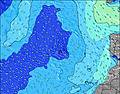 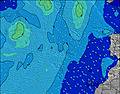 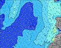 | ||||||||||||||||||||||||||||||||||||||||||||||||||||
| Wave Height (m) & direction (?) | ||||||||||||||||||||||||||||||||||||||||||||||||||||||||||||
| Period(s) (?) | 13 | 10 | 10 | 10 | 10 | 9 | 11 | 11 | 10 | 10 | 10 | 10 | 10 | 10 | 9 | 9 | 9 | 9 | 9 | 9 | 9 | 8 | 8 | 8 | 8 | 6 | 6 | 8 | 8 | 8 | 7 | 7 | 7 | 7 | 6 | 6 | 6 | 7 | 7 | 7 | 7 | 7 | 7 | 7 | 7 | 7 | 7 | 7 | 7 | 7 | 7 | 7 | 8 | 8 | 8 | 9 | 9 | 9 | 9 | 9 |
Wave (?)Graph | ||||||||||||||||||||||||||||||||||||||||||||||||||||||||||||
| Energy (?) | 215 | 239 | 234 | 239 | 198 | 130 | 82 | 181 | 167 | 194 | 194 | 230 | 225 | 145 | 136 | 106 | 103 | 101 | 78 | 76 | 54 | 51 | 161 | 157 | 143 | 57 | 82 | 130 | 130 | 72 | 83 | 83 | 99 | 77 | 55 | 58 | 96 | 66 | 127 | 124 | 157 | 153 | 140 | 132 | 129 | 102 | 110 | 144 | 176 | 186 | 197 | 208 | 237 | 284 | 310 | 442 | 495 | 473 | 412 | 412 |
Wind (km/h) | ||||||||||||||||||||||||||||||||||||||||||||||||||||||||||||
| Wind State (?) onshore cross-onshore cross-shore cross-offshore offshore glassy | cross | cross | cross | cross | cross | cross | cross | cross | cross | cross | cross | cross | cross | cross | cross | cross | cross | cross | cross | cross | cross | cross | cross | cross | cross | cross | cross | cross- on | cross | cross | cross | cross | cross | cross | cross | cross | cross | cross | cross | cross | cross | cross | cross | cross | cross- on | cross | cross | cross | cross | cross | cross | cross | cross- on | cross | cross | cross | cross | cross | cross | cross |
High Tide / height (m) | 11:58AM 1.59 | 12:03AM 1.78 | 12:30PM 1.71 | 12:35AM 1.87 | 12:59PM 1.82 | 1:06AM 1.94 | 1:27PM 1.91 | 1:36AM 1.97 | 1:54PM 1.96 | 2:06AM 1.97 | 2:23PM 1.98 | 2:36AM 1.94 | 2:52PM 1.97 | 3:08AM 1.88 | ||||||||||||||||||||||||||||||||||||||||||||||
Low Tide / height (m) | 5:50AM 0.46 | 5:54PM 0.54 | 6:21AM 0.35 | 6:27PM 0.42 | 6:49AM 0.26 | 6:57PM 0.32 | 7:16AM 0.20 | 7:27PM 0.25 | 7:44AM 0.16 | 7:57PM 0.20 | 8:11AM 0.15 | 8:27PM 0.18 | 8:39AM 0.18 | 8:58PM 0.20 | 9:09AM 0.23 | |||||||||||||||||||||||||||||||||||||||||||||
Friday 19 | Saturday 20 | Sunday 21 | Monday 22 | Tuesday 23 | Wednesday 24 | Thursday 25 | Friday 26 | |||||||||||||||||||||||||||||||||||||||||||||||||||||
| Sunrise | - | - | 7:31 | - | - | - | - | - | - | - | 7:31 | - | - | - | - | - | - | - | 7:30 | - | - | - | - | - | - | - | 7:28 | - | - | - | - | - | - | - | 7:28 | - | - | - | - | - | - | - | 7:26 | - | - | - | - | - | - | - | 7:26 | - | - | - | - | - | - | - | 7:24 | - |
| Sunset | - | - | - | - | - | 8:29 | - | - | - | - | - | - | - | 8:29 | - | - | - | - | - | - | - | 8:30 | - | - | - | - | - | - | - | 8:30 | - | - | - | - | - | - | - | 8:30 | - | - | - | - | - | - | - | 8:30 | - | - | - | - | - | - | - | 8:31 | - | - | - | - | - | - |
Rain (mm) | - | - | - | - | - | - | - | - | - | - | - | - | - | - | - | - | - | - | - | - | - | - | - | - | - | - | - | - | - | - | - | - | - | - | - | - | - | - | - | - | - | - | - | - | - | - | - | - | - | - | - | - | - | - | - | - | - | - | - | - |
| Temp. °C | 19 | 19 | 20 | 21 | 22 | 22 | 20 | 19 | 19 | 19 | 20 | 21 | 22 | 21 | 20 | 19 | 19 | 19 | 20 | 21 | 21 | 20 | 19 | 18 | 18 | 18 | 19 | 20 | 21 | 20 | 19 | 19 | 18 | 18 | 20 | 21 | 22 | 21 | 20 | 19 | 19 | 19 | 21 | 22 | 22 | 21 | 19 | 19 | 18 | 18 | 19 | 21 | 20 | 20 | 19 | 18 | 18 | 17 | 18 | 20 |
| Feels °C (?) | 17 | 17 | 18 | 20 | 20 | 19 | 18 | 17 | 17 | 17 | 18 | 19 | 19 | 18 | 17 | 16 | 16 | 16 | 17 | 18 | 19 | 17 | 16 | 14 | 15 | 15 | 16 | 18 | 19 | 19 | 16 | 16 | 16 | 16 | 18 | 19 | 20 | 19 | 18 | 16 | 16 | 16 | 18 | 19 | 19 | 17 | 16 | 16 | 14 | 14 | 15 | 18 | 17 | 15 | 15 | 13 | 14 | 12 | 13 | 16 |
FREE! Surf-Forecast.com widget for your website
The surf report / weather widget below is available to embed on third party websites free of charge and provides a summary of our Arinaga surf forecast. Simply grab the html code snippet that we provide and paste it into your own site. You can choose your preferred language and metric/imperial units for the surf forecast feed to suit users of your site. Click here to get the code.


 Nearest