

- Forecast
- Maps
- Live
- Weather State
- Spot Information
Marengo Surf Forecast
/ VIC – Cape Otway (10 breaks) / Victoria (127 breaks) /
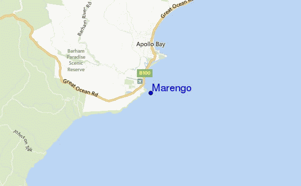
Marengo surf Forecast / VIC – Cape Otway / Australia
- Map Icons:
 Break
Break Live Wave Height (m)
 Live Wind Speed (km/h)
 Surf Rating (10 Max)
 Ocean Swells (m)
- Wind Speed (km/h)
How big are the waves at Marengo today?
The current surf forecast for Marengo at 6PM is: 2.5m 12s primary swell from a Southwest direction and 1.7m 12s secondary swell from a South-southwest direction, 0.8m 15s secondary swell from a South-southwest direction (forecast issued at 03:00pm April 25). The wind direction is predicted to be cross-offshore and the swell rating is 5.
| Time (AEST) & Date | Wave Height | Wave Period |
|---|---|---|
| Morning (25 Apr) | - | - |
| Afternoon (25 Apr) | 8ft (2.5m) | 12s |
| Evening (25 Apr) | 10ft (3.0m) | 12s |
Table - waves today at Marengo. (Swell directed towards the surf break)
Thursday 25 | Friday 26 | Saturday 27 | Sunday 28 | Monday 29 | Tuesday 30 | Wednesday 01 | Thursday 02 | |||||||||||||||||||||||||||||||||||||||||||||||||||||
| 1 PM | 4 PM | 7 PM | 10 PM | 1 AM | 4 AM | 7 AM | 10 AM | 1 PM | 4 PM | 7 PM | 10 PM | 1 AM | 4 AM | 7 AM | 10 AM | 1 PM | 4 PM | 7 PM | 10 PM | 1 AM | 4 AM | 7 AM | 10 AM | 1 PM | 4 PM | 7 PM | 10 PM | 1 AM | 4 AM | 7 AM | 10 AM | 1 PM | 4 PM | 7 PM | 10 PM | 1 AM | 4 AM | 7 AM | 10 AM | 1 PM | 4 PM | 7 PM | 10 PM | 1 AM | 4 AM | 7 AM | 10 AM | 1 PM | 4 PM | 7 PM | 10 PM | 1 AM | 4 AM | 7 AM | 10 AM | 1 PM | 4 PM | 7 PM | 10 PM | |
Rating (10 max) | ||||||||||||||||||||||||||||||||||||||||||||||||||||||||||||
Swell Height Map |    |    |    |   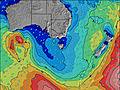 | 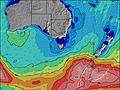 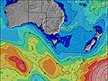 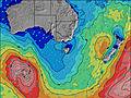 | 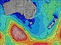 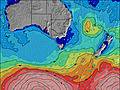 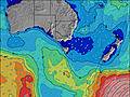 | 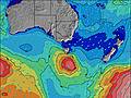 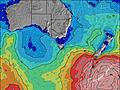 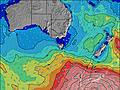 | 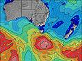 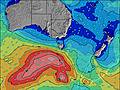 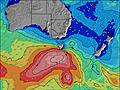 | ||||||||||||||||||||||||||||||||||||||||||||||||||||
| Wave Height (m) & direction (?) | ||||||||||||||||||||||||||||||||||||||||||||||||||||||||||||
| Period(s) (?) | 13 | 12 | 12 | 15 | 16 | 15 | 15 | 15 | 15 | 15 | 14 | 14 | 14 | 14 | 13 | 13 | 13 | 12 | 14 | 14 | 14 | 14 | 14 | 14 | 14 | 14 | 14 | 15 | 15 | 15 | 14 | 13 | 12 | 12 | 12 | 12 | 12 | 12 | 14 | 14 | 15 | 15 | 15 | 14 | 14 | 14 | 14 | 13 | 13 | 13 | 13 | 14 | 13 | 13 | 13 | 13 | 12 | 12 | 8 | 9 |
Wave (?)Graph | ||||||||||||||||||||||||||||||||||||||||||||||||||||||||||||
| Energy (?) | 2179 | 1883 | 2779 | 2272 | 3283 | 3335 | 3204 | 3034 | 2792 | 2529 | 2317 | 1848 | 1629 | 1322 | 1186 | 1002 | 928 | 784 | 1042 | 947 | 947 | 834 | 822 | 721 | 711 | 721 | 833 | 844 | 757 | 686 | 706 | 3264 | 3235 | 1801 | 3599 | 3679 | 3804 | 1486 | 2140 | 2383 | 2906 | 2736 | 2411 | 2412 | 2200 | 1835 | 1553 | 1303 | 2345 | 2986 | 581 | 675 | 3293 | 2810 | 2162 | 1711 | 1354 | 525 | 765 | 1113 |
Wind (km/h) | ||||||||||||||||||||||||||||||||||||||||||||||||||||||||||||
| Wind State (?) onshore cross-onshore cross-shore cross-offshore offshore glassy | cross- off | cross- off | cross- off | cross- off | cross- off | cross- off | cross- off | cross- off | cross- off | cross- off | cross- off | cross- off | off | off | cross- off | glass | cross- off | cross- off | glass | cross | cross | cross | cross- off | cross- off | cross | cross | cross | cross- off | cross- off | cross- off | cross- off | off | off | off | off | cross- off | cross- off | cross- off | cross- off | cross- off | cross | cross- off | cross- off | cross- off | cross- off | cross- off | cross- off | cross | cross | cross- off | cross- off | cross- off | cross- off | cross- off | cross- off | cross- off | cross- off | cross- off | cross- off | cross- off |
High Tide / height (m) | 1:26PM 1.76 | 2:15AM 2.40 | 1:51PM 1.76 | 2:44AM 2.44 | 2:16PM 1.76 | 3:15AM 2.43 | 2:41PM 1.74 | 3:47AM 2.37 | 3:07PM 1.70 | 4:22AM 2.26 | 3:37PM 1.65 | 4:59AM 2.13 | 4:15PM 1.59 | 5:41AM 1.97 | 5:07PM 1.50 | |||||||||||||||||||||||||||||||||||||||||||||
Low Tide / height (m) | 7:33PM 0.31 | 8:32AM 0.75 | 7:59PM 0.23 | 9:01AM 0.77 | 8:27PM 0.18 | 9:30AM 0.81 | 8:56PM 0.15 | 9:59AM 0.86 | 9:27PM 0.17 | 10:31AM 0.92 | 10:01PM 0.25 | 11:07AM 0.96 | 10:40PM 0.39 | 11:53AM 0.99 | ||||||||||||||||||||||||||||||||||||||||||||||
Thursday 25 | Friday 26 | Saturday 27 | Sunday 28 | Monday 29 | Tuesday 30 | Wednesday 01 | Thursday 02 | |||||||||||||||||||||||||||||||||||||||||||||||||||||
| Sunrise | - | - | - | - | - | - | - | 7:03 | - | - | - | - | - | - | - | 7:03 | - | - | - | - | - | - | - | 7:05 | - | - | - | - | - | - | - | 7:05 | - | - | - | - | - | - | - | 7:07 | - | - | - | - | - | - | - | 7:07 | - | - | - | - | - | - | - | 7:07 | - | - | - | - |
| Sunset | - | 5:43 | - | - | - | - | - | - | - | 5:42 | - | - | - | - | - | - | - | 5:40 | - | - | - | - | - | - | - | 5:38 | - | - | - | - | - | - | - | 5:37 | - | - | - | - | - | - | - | 5:37 | - | - | - | - | - | - | - | 5:36 | - | - | - | - | - | - | - | 5:35 | - | - |
Rain (mm) | - | - | - | - | - | - | - | - | - | - | - | - | - | - | - | - | - | - | - | - | - | - | - | - | - | - | - | - | - | - | 1 | 2 | 1 | - | - | 1 | 1 | 1 | 1 | 2 | 2 | 1 | 2 | - | - | 1 | 2 | 3 | 2 | 1 | 1 | 1 | 1 | 1 | 2 | 3 | 1 | 1 | 1 | 1 |
| Temp. °C | 14 | 14 | 13 | 12 | 13 | 12 | 12 | 13 | 13 | 13 | 11 | 11 | 11 | 11 | 10 | 13 | 14 | 13 | 11 | 10 | 11 | 11 | 11 | 14 | 18 | 19 | 17 | 16 | 16 | 15 | 13 | 13 | 12 | 13 | 12 | 10 | 10 | 10 | 10 | 10 | 9 | 10 | 11 | 11 | 11 | 10 | 11 | 11 | 12 | 12 | 13 | 12 | 12 | 12 | 11 | 11 | 12 | 12 | 12 | 13 |
| Feels °C (?) | 9 | 9 | 9 | 9 | 9 | 9 | 9 | 10 | 9 | 10 | 8 | 9 | 9 | 9 | 8 | 11 | 12 | 11 | 10 | 8 | 9 | 9 | 9 | 11 | 15 | 16 | 13 | 11 | 10 | 9 | 8 | 9 | 6 | 7 | 6 | 6 | 6 | 5 | 5 | 5 | 5 | 6 | 6 | 6 | 7 | 6 | 7 | 6 | 6 | 6 | 6 | 6 | 5 | 5 | 4 | 4 | 5 | 5 | 5 | 6 |
FREE! Surf-Forecast.com widget for your website
The surf report / weather widget below is available to embed on third party websites free of charge and provides a summary of our Marengo surf forecast. Simply grab the html code snippet that we provide and paste it into your own site. You can choose your preferred language and metric/imperial units for the surf forecast feed to suit users of your site. Click here to get the code.


 Nearest