

- Forecast
- Maps
- Live
- Weather State
- Spot Information
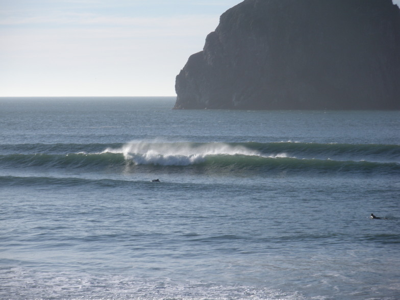
Pacific City/Cape Kiwanda Surf Forecast
/ Oregon North (24 breaks) / Oregon (49 breaks) /
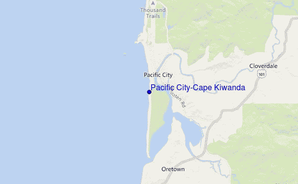
Pacific City/Cape Kiwanda surf Forecast / Oregon North / USA
- Map Icons:
 Break
Break Live Wave Height (m)
 Live Wind Speed (km/h)
 Surf Rating (10 Max)
 Ocean Swells (m)
- Wind Speed (km/h)
How big are the waves at Pacific City/Cape Kiwanda today?
The current surf forecast for Pacific City/Cape Kiwanda at 11PM is: 1.3m 11s primary swell from a West-northwest direction and 0.5m 16s secondary swell from a Southwest direction, 1.6m 6s secondary swell from a North-northwest direction (forecast issued at 04:00pm April 22). The wind direction is predicted to be cross-shore and the swell rating is 2.
| Time (PDT) & Date | Wave Height | Wave Period |
|---|---|---|
| Morning (22 Apr) | - | - |
| Afternoon (22 Apr) | 6ft (1.8m) | 10s |
| Evening (22 Apr) | 4.5ft (1.4m) | 11s |
Table - waves today at Pacific City/Cape Kiwanda. (Swell directed towards the surf break)
Monday 22 | Tuesday 23 | Wednesday 24 | Thursday 25 | Friday 26 | Saturday 27 | Sunday 28 | Monday 29 | |||||||||||||||||||||||||||||||||||||||||||||||||||||
| 2 PM | 5 PM | 8 PM | 11 PM | 2 AM | 5 AM | 8 AM | 11 AM | 2 PM | 5 PM | 8 PM | 11 PM | 2 AM | 5 AM | 8 AM | 11 AM | 2 PM | 5 PM | 8 PM | 11 PM | 2 AM | 5 AM | 8 AM | 11 AM | 2 PM | 5 PM | 8 PM | 11 PM | 2 AM | 5 AM | 8 AM | 11 AM | 2 PM | 5 PM | 8 PM | 11 PM | 2 AM | 5 AM | 8 AM | 11 AM | 2 PM | 5 PM | 8 PM | 11 PM | 2 AM | 5 AM | 8 AM | 11 AM | 2 PM | 5 PM | 8 PM | 11 PM | 2 AM | 5 AM | 8 AM | 11 AM | 2 PM | 5 PM | 8 PM | 11 PM | |
Rating (10 max) | ||||||||||||||||||||||||||||||||||||||||||||||||||||||||||||
Swell Height Map |    |  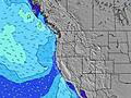 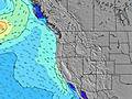 |  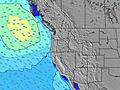 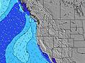 | 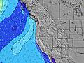 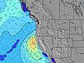 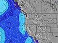 | 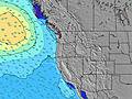 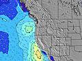 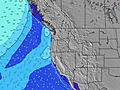 | 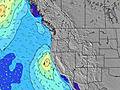 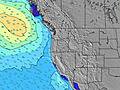 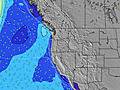 | 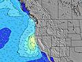 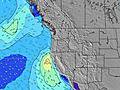 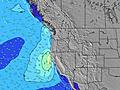 | 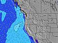 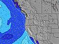 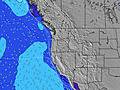 | ||||||||||||||||||||||||||||||||||||||||||||||||||||
| Wave Height (m) & direction (?) | ||||||||||||||||||||||||||||||||||||||||||||||||||||||||||||
| Period(s) (?) | 10 | 11 | 11 | 11 | 11 | 10 | 10 | 10 | 16 | 16 | 16 | 15 | 15 | 15 | 9 | 15 | 15 | 12 | 11 | 11 | 10 | 10 | 10 | 16 | 16 | 6 | 7 | 8 | 8 | 8 | 8 | 9 | 9 | 9 | 9 | 8 | 8 | 8 | 8 | 14 | 13 | 13 | 13 | 13 | 12 | 7 | 8 | 12 | 12 | 12 | 12 | 11 | 11 | 11 | 11 | 11 | 13 | 12 | 13 | 13 |
Wave (?)Graph | ||||||||||||||||||||||||||||||||||||||||||||||||||||||||||||
| Energy (?) | 676 | 485 | 423 | 359 | 690 | 274 | 400 | 205 | 166 | 157 | 153 | 143 | 139 | 137 | 119 | 141 | 143 | 275 | 458 | 404 | 347 | 261 | 220 | 153 | 151 | 277 | 246 | 509 | 500 | 443 | 401 | 567 | 810 | 1007 | 860 | 541 | 388 | 339 | 297 | 281 | 253 | 269 | 265 | 238 | 203 | 305 | 239 | 205 | 827 | 1136 | 1230 | 1106 | 1086 | 1111 | 1111 | 1132 | 2470 | 2459 | 2796 | 3118 |
Wind (km/h) | ||||||||||||||||||||||||||||||||||||||||||||||||||||||||||||
| Wind State (?) onshore cross-onshore cross-shore cross-offshore offshore glassy | cross | cross | cross | cross | cross- off | cross- off | glass | cross- on | cross- on | cross | cross | cross | cross | glass | glass | on | on | on | cross | cross- off | cross | cross | cross- on | cross- on | cross | cross | cross- on | cross- on | cross- on | cross- on | on | on | cross- on | cross- on | cross- on | on | on | on | cross- on | cross- on | cross- on | cross- on | cross- off | cross- off | cross- off | cross | cross | cross- on | cross- on | cross- on | cross- on | cross- on | cross | cross | cross | cross- on | cross- on | cross- on | cross- on | cross |
High Tide / height (m) | 12:49PM 1.82 | 12:34AM 2.19 | 1:30PM 1.82 | 12:59AM 2.25 | 2:12PM 1.81 | 1:24AM 2.28 | 2:55PM 1.77 | 1:53AM 2.30 | 3:41PM 1.71 | 2:25AM 2.28 | 4:33PM 1.65 | 3:03AM 2.24 | 5:33PM 1.59 | 3:48AM 2.16 | 6:40PM 1.58 | |||||||||||||||||||||||||||||||||||||||||||||
Low Tide / height (m) | 6:45PM 0.44 | 7:29AM -0.00 | 7:14PM 0.54 | 8:03AM -0.10 | 7:44PM 0.64 | 8:38AM -0.16 | 8:14PM 0.74 | 9:16AM -0.19 | 8:47PM 0.84 | 9:58AM -0.19 | 9:24PM 0.92 | 10:47AM -0.16 | 10:10PM 0.98 | 11:42AM -0.13 | ||||||||||||||||||||||||||||||||||||||||||||||
Monday 22 | Tuesday 23 | Wednesday 24 | Thursday 25 | Friday 26 | Saturday 27 | Sunday 28 | Monday 29 | |||||||||||||||||||||||||||||||||||||||||||||||||||||
| Sunrise | - | - | - | - | - | - | 6:16 | - | - | - | - | - | - | - | 6:13 | - | - | - | - | - | - | - | 6:11 | - | - | - | - | - | - | - | 6:11 | - | - | - | - | - | - | - | 6:09 | - | - | - | - | - | - | - | 6:07 | - | - | - | - | - | - | - | 6:05 | - | - | - | - | - |
| Sunset | - | - | 8:10 | - | - | - | - | - | - | - | 8:12 | - | - | - | - | - | - | - | 8:13 | - | - | - | - | - | - | - | 8:15 | - | - | - | - | - | - | - | 8:15 | - | - | - | - | - | - | - | 8:16 | - | - | - | - | - | - | - | 8:19 | - | - | - | - | - | - | - | 8:20 | - |
Rain (mm) | - | - | - | - | - | - | - | - | - | - | - | - | - | - | - | - | - | - | - | - | - | 3 | 5 | 5 | 4 | 6 | 6 | 3 | 1 | 2 | 3 | 3 | 3 | 1 | - | - | - | - | - | - | - | - | 1 | - | 1 | 1 | 1 | 1 | 1 | 1 | 1 | 1 | 1 | 1 | 1 | 2 | 2 | 2 | 2 | 1 |
| Temp. °C | 12 | 12 | 10 | 10 | 10 | 10 | 10 | 13 | 12 | 11 | 9 | 8 | 8 | 8 | 9 | 11 | 11 | 11 | 10 | 10 | 10 | 10 | 10 | 9 | 10 | 10 | 10 | 10 | 10 | 9 | 10 | 10 | 10 | 10 | 9 | 9 | 9 | 9 | 9 | 10 | 10 | 10 | 8 | 8 | 8 | 9 | 10 | 10 | 11 | 11 | 10 | 8 | 8 | 8 | 8 | 9 | 10 | 10 | 9 | 8 |
| Feels °C (?) | 7 | 7 | 6 | 6 | 7 | 7 | 8 | 10 | 9 | 7 | 6 | 5 | 6 | 6 | 8 | 9 | 8 | 9 | 8 | 8 | 7 | 6 | 6 | 4 | 4 | 3 | 6 | 6 | 6 | 5 | 7 | 8 | 5 | 5 | 6 | 6 | 7 | 7 | 6 | 5 | 4 | 5 | 4 | 3 | 3 | 4 | 7 | 6 | 7 | 5 | 5 | 4 | 4 | 3 | 3 | 3 | 3 | 4 | 4 | 3 |
FREE! Surf-Forecast.com widget for your website
The surf report / weather widget below is available to embed on third party websites free of charge and provides a summary of our Pacific City/Cape Kiwanda surf forecast. Simply grab the html code snippet that we provide and paste it into your own site. You can choose your preferred language and metric/imperial units for the surf forecast feed to suit users of your site. Click here to get the code.


 Nearest