

- Forecast
- Maps
- Live
- Weather State
- Spot Information
Spanish Bay-Dunes Surf Forecast
/ CAL – Monterey (18 breaks) / California (404 breaks) /
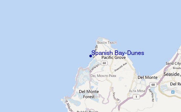
Spanish Bay-Dunes surf Forecast / CAL – Monterey / USA
- Map Icons:
 Break
Break Live Wave Height (m)
 Live Wind Speed (km/h)
 Surf Rating (10 Max)
 Ocean Swells (m)
- Wind Speed (km/h)
How big are the waves at Spanish Bay-Dunes today?
The current surf forecast for Spanish Bay-Dunes at 7PM is: 0.5m 16s primary swell from a South direction and 0.9m 9s secondary swell from a West-northwest direction, 0.5m 16s secondary swell from a Southwest direction (forecast issued at 04:00pm April 24). The wind direction is predicted to be cross-shore.
| Time (PDT) & Date | Wave Height | Wave Period |
|---|---|---|
| Morning (24 Apr) | - | - |
| Afternoon (24 Apr) | 3.5ft (1.0m) | 10s |
| Evening (24 Apr) | 3ft (0.9m) | 9s |
Table - waves today at Spanish Bay-Dunes. (Swell directed towards the surf break)
Wednesday 24 | Thursday 25 | Friday 26 | Saturday 27 | Sunday 28 | Monday 29 | Tuesday 30 | Wednesday 01 | |||||||||||||||||||||||||||||||||||||||||||||||||||||
| 2 PM | 5 PM | 8 PM | 11 PM | 2 AM | 5 AM | 8 AM | 11 AM | 2 PM | 5 PM | 8 PM | 11 PM | 2 AM | 5 AM | 8 AM | 11 AM | 2 PM | 5 PM | 8 PM | 11 PM | 2 AM | 5 AM | 8 AM | 11 AM | 2 PM | 5 PM | 8 PM | 11 PM | 2 AM | 5 AM | 8 AM | 11 AM | 2 PM | 5 PM | 8 PM | 11 PM | 2 AM | 5 AM | 8 AM | 11 AM | 2 PM | 5 PM | 8 PM | 11 PM | 2 AM | 5 AM | 8 AM | 11 AM | 2 PM | 5 PM | 8 PM | 11 PM | 2 AM | 5 AM | 8 AM | 11 AM | 2 PM | 5 PM | 8 PM | 11 PM | |
Rating (10 max) | ||||||||||||||||||||||||||||||||||||||||||||||||||||||||||||
Swell Height Map |    |    |    |    |  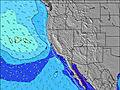 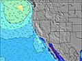 |  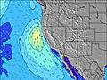 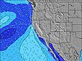 |  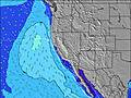 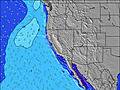 |  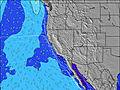 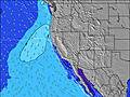 | ||||||||||||||||||||||||||||||||||||||||||||||||||||
| Wave Height (m) & direction (?) | ||||||||||||||||||||||||||||||||||||||||||||||||||||||||||||
| Period(s) (?) | 10 | 10 | 9 | 16 | 15 | 15 | 7 | 8 | 8 | 7 | 18 | 18 | 18 | 18 | 18 | 18 | 18 | 17 | 7 | 8 | 9 | 9 | 9 | 9 | 9 | 9 | 8 | 9 | 9 | 9 | 8 | 8 | 8 | 8 | 7 | 8 | 8 | 8 | 9 | 9 | 10 | 10 | 9 | 10 | 10 | 10 | 10 | 9 | 9 | 9 | 8 | 8 | 8 | 8 | 8 | 11 | 11 | 10 | 10 | 10 |
Wave (?)Graph | ||||||||||||||||||||||||||||||||||||||||||||||||||||||||||||
| Energy (?) | 179 | 175 | 124 | 122 | 113 | 110 | 147 | 264 | 314 | 173 | 113 | 124 | 123 | 152 | 209 | 207 | 246 | 203 | 395 | 819 | 1009 | 1080 | 1202 | 1081 | 864 | 864 | 844 | 769 | 732 | 754 | 634 | 513 | 489 | 452 | 452 | 490 | 527 | 567 | 790 | 1182 | 1391 | 1448 | 1526 | 1608 | 1363 | 1151 | 1007 | 965 | 811 | 623 | 585 | 540 | 450 | 322 | 270 | 712 | 639 | 450 | 400 | 367 |
Wind (km/h) | ||||||||||||||||||||||||||||||||||||||||||||||||||||||||||||
| Wind State (?) onshore cross-onshore cross-shore cross-offshore offshore glassy | cross | cross | cross | glass | on | on | on | on | cross- on | cross- on | on | cross- on | on | on | on | on | on | on | on | on | on | on | cross- on | on | on | on | on | on | on | on | on | on | on | on | on | on | on | on | on | on | on | on | on | on | on | on | on | on | on | on | on | on | on | cross- on | cross | on | cross- on | cross- on | cross- on | cross- on |
High Tide / height (m) | 12:13PM 1.08 | 11:10PM 1.60 | 1:03PM 1.03 | 11:37PM 1.61 | 2:02PM 0.99 | 12:09AM 1.61 | 3:13PM 0.96 | 12:48AM 1.58 | 4:38PM 0.97 | 1:37AM 1.54 | 5:57PM 1.01 | 2:41AM 1.48 | 6:43PM 1.09 | 4:00AM 1.41 | 7:16PM 1.18 | |||||||||||||||||||||||||||||||||||||||||||||
Low Tide / height (m) | 4:59PM 0.61 | 6:26AM -0.11 | 5:24PM 0.70 | 7:08AM -0.14 | 5:51PM 0.79 | 7:55AM -0.15 | 6:21PM 0.86 | 8:50AM -0.15 | 7:04PM 0.93 | 9:51AM -0.14 | 8:24PM 0.98 | 10:54AM -0.14 | 10:19PM 0.96 | 11:52AM -0.13 | ||||||||||||||||||||||||||||||||||||||||||||||
Wednesday 24 | Thursday 25 | Friday 26 | Saturday 27 | Sunday 28 | Monday 29 | Tuesday 30 | Wednesday 01 | |||||||||||||||||||||||||||||||||||||||||||||||||||||
| Sunrise | - | - | - | - | - | - | 6:20 | - | - | - | - | - | - | - | 6:18 | - | - | - | - | - | - | - | 6:16 | - | - | - | - | - | - | - | 6:16 | - | - | - | - | - | - | - | 6:15 | - | - | - | - | - | - | - | 6:13 | - | - | - | - | - | - | - | 6:13 | - | - | - | - | - |
| Sunset | - | 7:50 | - | - | - | - | - | - | - | 7:51 | - | - | - | - | - | - | - | 7:52 | - | - | - | - | - | - | - | 7:52 | - | - | - | - | - | - | - | 7:53 | - | - | - | - | - | - | - | 7:53 | - | - | - | - | - | - | - | 7:54 | - | - | - | - | - | - | - | 7:55 | - | - |
Rain (mm) | - | - | - | - | - | - | - | - | - | - | - | - | - | - | - | - | - | - | - | - | - | - | - | - | - | - | - | - | - | - | - | - | - | - | - | - | - | - | - | - | - | - | - | - | - | - | - | - | - | - | - | - | - | - | - | - | - | - | - | - |
| Temp. °C | 13 | 13 | 13 | 12 | 11 | 11 | 11 | 12 | 12 | 12 | 12 | 12 | 12 | 12 | 13 | 13 | 13 | 13 | 12 | 11 | 11 | 10 | 10 | 11 | 11 | 11 | 11 | 10 | 10 | 10 | 11 | 12 | 12 | 12 | 11 | 10 | 10 | 10 | 10 | 11 | 12 | 13 | 11 | 10 | 10 | 10 | 10 | 11 | 12 | 11 | 11 | 10 | 10 | 9 | 9 | 11 | 12 | 13 | 13 | 12 |
| Feels °C (?) | 10 | 10 | 11 | 11 | 8 | 8 | 8 | 8 | 7 | 8 | 9 | 10 | 10 | 9 | 9 | 8 | 7 | 7 | 6 | 5 | 6 | 5 | 8 | 8 | 6 | 4 | 5 | 5 | 6 | 7 | 9 | 9 | 7 | 6 | 5 | 5 | 5 | 6 | 7 | 8 | 7 | 8 | 5 | 6 | 7 | 7 | 7 | 7 | 7 | 5 | 6 | 6 | 7 | 6 | 7 | 9 | 9 | 10 | 11 | 10 |
FREE! Surf-Forecast.com widget for your website
The surf report / weather widget below is available to embed on third party websites free of charge and provides a summary of our Spanish Bay-Dunes surf forecast. Simply grab the html code snippet that we provide and paste it into your own site. You can choose your preferred language and metric/imperial units for the surf forecast feed to suit users of your site. Click here to get the code.


 Nearest