

- Forecast
- Maps
- Live
- Weather State
- Spot Information

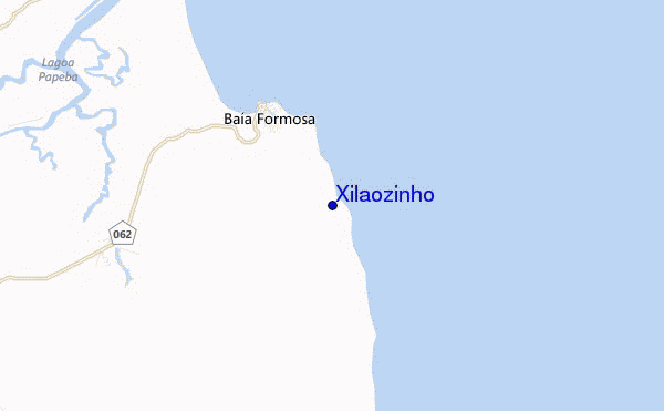
Xilaozinho surf Forecast / Rio Grande Do Norte / Brazil
- Map Icons:
 Break
Break Live Wave Height (m)
 Live Wind Speed (km/h)
 Surf Rating (10 Max)
 Ocean Swells (m)
- Wind Speed (km/h)
How big are the waves at Xilaozinho today?
The current surf forecast for Xilaozinho at 8AM is: 0.9m 7s primary swell from a East-southeast direction and 0.8m 7s secondary swell from a East direction, 0.5m 8s secondary swell from a Northeast direction (forecast issued at 02:00am April 25). The wind direction is predicted to be cross-shore.
| Time (-03) & Date | Wave Height | Wave Period |
|---|---|---|
| Morning (25 Apr) | 3ft (0.9m) | 7s |
| Afternoon (25 Apr) | 3ft (0.9m) | 7s |
| Evening (25 Apr) | 5ft (1.5m) | 7s |
Table - waves today at Xilaozinho. (Swell directed towards the surf break)
Thursday 25 | Friday 26 | Saturday 27 | Sunday 28 | Monday 29 | Tuesday 30 | Wednesday 01 | Thursday 02 | |||||||||||||||||||||||||||||||||||||||||||||||||||||
| 0 AM | 3 AM | 6 AM | 9 AM | 12 PM | 3 PM | 6 PM | 9 PM | 0 AM | 3 AM | 6 AM | 9 AM | 12 PM | 3 PM | 6 PM | 9 PM | 0 AM | 3 AM | 6 AM | 9 AM | 12 PM | 3 PM | 6 PM | 9 PM | 0 AM | 3 AM | 6 AM | 9 AM | 12 PM | 3 PM | 6 PM | 9 PM | 0 AM | 3 AM | 6 AM | 9 AM | 12 PM | 3 PM | 6 PM | 9 PM | 0 AM | 3 AM | 6 AM | 9 AM | 12 PM | 3 PM | 6 PM | 9 PM | 0 AM | 3 AM | 6 AM | 9 AM | 12 PM | 3 PM | 6 PM | 9 PM | 0 AM | 3 AM | 6 AM | 9 AM | |
Rating (10 max) | ||||||||||||||||||||||||||||||||||||||||||||||||||||||||||||
Swell Height Map |    |    |    |    |   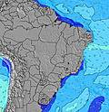 |  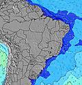 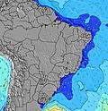 |  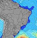 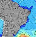 |  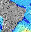 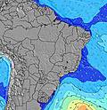 | ||||||||||||||||||||||||||||||||||||||||||||||||||||
| Wave Height (m) & direction (?) | ||||||||||||||||||||||||||||||||||||||||||||||||||||||||||||
| Period(s) (?) | 7 | 7 | 7 | 7 | 7 | 7 | 7 | 7 | 8 | 8 | 8 | 8 | 8 | 8 | 8 | 8 | 8 | 8 | 8 | 8 | 8 | 8 | 8 | 8 | 8 | 8 | 8 | 8 | 8 | 8 | 8 | 8 | 8 | 8 | 8 | 8 | 8 | 8 | 8 | 8 | 8 | 8 | 8 | 8 | 8 | 8 | 8 | 7 | 7 | 7 | 7 | 7 | 8 | 8 | 8 | 7 | 7 | 7 | 8 | 8 |
Wave (?)Graph | ||||||||||||||||||||||||||||||||||||||||||||||||||||||||||||
| Energy (?) | 74 | 77 | 77 | 77 | 61 | 79 | 188 | 242 | 268 | 227 | 322 | 183 | 196 | 259 | 403 | 451 | 451 | 451 | 432 | 373 | 335 | 319 | 300 | 300 | 284 | 307 | 307 | 307 | 177 | 153 | 157 | 153 | 153 | 127 | 130 | 105 | 134 | 137 | 220 | 207 | 207 | 220 | 142 | 226 | 226 | 226 | 160 | 156 | 156 | 155 | 155 | 131 | 135 | 110 | 143 | 177 | 151 | 127 | 240 | 256 |
Wind (km/h) | ||||||||||||||||||||||||||||||||||||||||||||||||||||||||||||
| Wind State (?) onshore cross-onshore cross-shore cross-offshore offshore glassy | cross- on | cross | cross | cross | cross | cross | cross | cross | cross | cross | cross | cross | cross | cross- on | cross | cross | cross | cross- off | cross- off | cross | cross- on | cross- on | cross- on | cross- on | cross- on | cross | cross- off | cross | cross- on | cross- on | cross- on | cross- on | cross | cross- off | cross- off | cross | cross- on | cross- on | cross- on | cross- on | cross- on | cross- on | cross- on | cross- on | on | on | cross- on | cross- on | cross | cross- off | cross- off | cross | cross | cross | cross | cross | cross | cross | cross- off | cross |
High Tide / height (m) | 4:38AM 2.13 | 4:59PM 2.06 | 5:10AM 2.09 | 5:35PM 1.97 | 5:46AM 2.01 | 6:15PM 1.87 | 6:28AM 1.93 | 7:03PM 1.76 | 7:19AM 1.84 | 8:05PM 1.67 | 8:25AM 1.78 | 9:22PM 1.64 | 9:44AM 1.79 | 10:46PM 1.70 | ||||||||||||||||||||||||||||||||||||||||||||||
Low Tide / height (m) | 10:48AM 0.20 | 11:00PM 0.31 | 11:22AM 0.24 | 11:34PM 0.39 | 12:00PM 0.32 | 12:12AM 0.49 | 12:45PM 0.42 | 12:59AM 0.60 | 1:43PM 0.52 | 2:02AM 0.71 | 3:00PM 0.58 | 3:26AM 0.76 | 4:26PM 0.56 | 4:53AM 0.72 | ||||||||||||||||||||||||||||||||||||||||||||||
Thursday 25 | Friday 26 | Saturday 27 | Sunday 28 | Monday 29 | Tuesday 30 | Wednesday 01 | Thursday 02 | |||||||||||||||||||||||||||||||||||||||||||||||||||||
| Sunrise | - | - | 5:20 | - | - | - | - | - | - | - | 5:20 | - | - | - | - | - | - | - | 5:20 | - | - | - | - | - | - | - | 5:20 | - | - | - | - | - | - | - | 5:20 | - | - | - | - | - | - | - | 5:20 | - | - | - | - | - | - | - | 5:20 | - | - | - | - | - | - | - | 5:20 | - |
| Sunset | - | - | - | - | - | 5:14 | - | - | - | - | - | - | - | 5:14 | - | - | - | - | - | - | - | 5:14 | - | - | - | - | - | - | - | 5:14 | - | - | - | - | - | - | - | 5:13 | - | - | - | - | - | - | - | 5:13 | - | - | - | - | - | - | - | 5:13 | - | - | - | - | - | - |
Rain (mm) | - | - | - | - | - | - | - | - | 1 | 1 | 2 | 3 | 2 | 5 | 10 | 7 | 8 | 6 | 7 | 4 | 2 | - | - | 1 | 4 | 1 | - | 1 | 1 | 1 | 1 | 1 | 1 | - | - | - | 1 | 1 | 1 | 3 | 6 | 6 | 6 | 7 | 3 | 2 | 1 | - | 1 | 1 | 1 | 1 | 2 | 1 | - | - | 1 | 3 | 3 | 2 |
| Temp. °C | 28 | 27 | 26 | 29 | 29 | 29 | 28 | 27 | 26 | 26 | 26 | 29 | 29 | 28 | 27 | 27 | 26 | 25 | 25 | 27 | 29 | 28 | 28 | 27 | 27 | 26 | 26 | 27 | 29 | 28 | 27 | 27 | 26 | 25 | 25 | 27 | 29 | 28 | 27 | 27 | 25 | 25 | 25 | 25 | 26 | 26 | 26 | 26 | 26 | 26 | 25 | 27 | 28 | 28 | 27 | 26 | 26 | 26 | 25 | 28 |
| Feels °C (?) | 30 | 29 | 28 | 30 | 30 | 30 | 30 | 29 | 28 | 28 | 28 | 30 | 29 | 29 | 30 | 30 | 29 | 28 | 29 | 31 | 32 | 30 | 30 | 29 | 30 | 29 | 29 | 29 | 31 | 30 | 30 | 30 | 29 | 28 | 28 | 29 | 31 | 30 | 29 | 30 | 28 | 28 | 27 | 29 | 29 | 29 | 29 | 29 | 29 | 29 | 27 | 29 | 29 | 29 | 29 | 28 | 29 | 29 | 27 | 30 |
FREE! Surf-Forecast.com widget for your website
The surf report / weather widget below is available to embed on third party websites free of charge and provides a summary of our Xilaozinho surf forecast. Simply grab the html code snippet that we provide and paste it into your own site. You can choose your preferred language and metric/imperial units for the surf forecast feed to suit users of your site. Click here to get the code.


 Nearest