- Forecast
- Maps
- Live
- Weather State
- Spot Information
Chatarras Golfvoorspelling
/ Puerto Rico (55 surf breaks) /
Golfvoorspellingen
Surfen in ChatarrasVoorspelling / Puerto Rico / Puerto Rico
Verwachting wordt bijgewerkt binnen uur min s Forecast update imminent
Chatarras golfvoorspelling is voor open zee vlakbij de kust. Brekende golven zullen vaak kleiner zijn op beschuttende stranden.
De zeetemperatuur in Chatarras vandaag is
28.8° C
(Wat iets warmer is dan gebruikelijk)Wordt bijgewerkt binnen uur min s Forecast update imminent
Tuesday 29 | Wednesday 30 | Thursday 31 | Friday 01 | |||||||||||||||||||||
| 5 PM | 8 PM | 11 PM | 2 AM | 5 AM | 8 AM | 11 AM | 2 PM | 5 PM | 8 PM | 11 PM | 2 AM | 5 AM | 8 AM | 11 AM | 2 PM | 5 PM | 8 PM | 11 PM | 2 AM | 5 AM | 8 AM | 11 AM | 2 PM | |
Waardering (10 max) | ||||||||||||||||||||||||
Golfhoogte kaart |   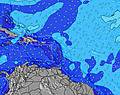 |    |    |   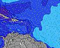 | ||||||||||||||||||||
| Golfhoogte (m) & richting (?) | ||||||||||||||||||||||||
| Periode(s) (?) | 8 | 8 | 8 | 8 | 8 | 8 | 8 | 8 | 8 | 8 | 8 | 8 | 5 | 5 | 6 | 7 | 6 | 6 | 6 | 6 | 6 | 7 | 7 | 6 |
Golf (?)Grafiek | ||||||||||||||||||||||||
| Energie (?) | 102 | 98 | 115 | 88 | 90 | 90 | 90 | 84 | 80 | 80 | 80 | 57 | 112 | 52 | 64 | 99 | 71 | 81 | 198 | 119 | 103 | 223 | 151 | 165 |
Wind (km/h) | ||||||||||||||||||||||||
| Wind (?) onshore cross-onshore cross-shore cross-offshore offshore glasachtig | cross | cross | cross- off | cross- off | cross- off | cross | cross | cross | cross | cross | cross | cross- off | cross- off | cross- off | cross | cross | cross | cross- off | cross- off | cross- off | cross- off | cross- off | cross- off | cross- off |
Vloed / hoogte (m) | 12:50AM 0.34 | 1:42PM 0.34 | 1:22AM 0.31 | 2:44PM 0.34 | 1:55AM 0.28 | |||||||||||||||||||
Eb / hoogte (m) | 6:43PM 0.09 | 7:14AM 0.05 | 7:38PM 0.13 | 7:53AM 0.04 | 8:41PM 0.16 | 8:35AM 0.03 | ||||||||||||||||||
Tuesday 29 | Wednesday 30 | Thursday 31 | Friday 01 | |||||||||||||||||||||
| Zonsopgang | - | - | - | - | - | 6:00 | - | - | - | - | - | - | - | 6:01 | - | - | - | - | - | - | - | 6:01 | - | - |
| Zonsondergang | 7:00 | - | - | - | - | - | - | - | 6:59 | - | - | - | - | - | - | - | 6:59 | - | - | - | - | - | - | - |
Regen (mm) | 1 | - | - | - | - | - | - | - | - | - | - | - | - | - | 1 | 1 | - | - | - | 1 | 1 | 1 | 1 | 1 |
| Temp. °C | 29 | 28 | 27 | 26 | 26 | 27 | 29 | 29 | 28 | 27 | 27 | 27 | 26 | 27 | 29 | 29 | 29 | 27 | 27 | 27 | 26 | 27 | 28 | 29 |
| Feels °C (?) | 31 | 30 | 30 | 28 | 28 | 28 | 29 | 29 | 28 | 28 | 28 | 29 | 28 | 29 | 30 | 28 | 29 | 28 | 29 | 29 | 28 | 28 | 28 | 30 |
- Map Icons:
 Break
Break Live Wave Height (m)
 Live Wind Speed (km/h)
 Surf Rating (10 Max)
 Ocean Swells (m)
- Wind Speed (km/h)
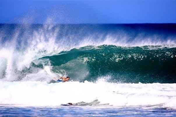
 Recente Eyeball Golfberichten voor Puerto Rico

Expand
<
>
View all
1 h 10 min ago
3 km/h
SSE
Clean
Please reload the page to see if there are any updates.
GRATIS Surf-Forecast.com widget voor je website
Het gratis surfbericht/weer widget hieronder is beschikbaar voor websites en geeft een samenvatting van de golfvoorspelling voor Chatarras. Kopieer de HTML-code en plak deze in je eigen site. Je kunt je eigen voorkeurstaal en eenheden kiezen zodat de voorspelling afgesteld is op de gebruikers van jouw site. Klik hier voor de code.


 Nearest