

- Forecast
- Maps
- Live
- Weather State
- Spot Information


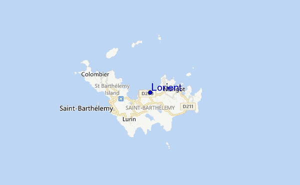
Lorient surf Forecast / Saint Barthélemy / Saint Barthélemy
- Map Icons:
 Break
Break Live Wave Height (m)
 Live Wind Speed (km/h)
 Surf Rating (10 Max)
 Ocean Swells (m)
- Wind Speed (km/h)
How big are the waves at Lorient today?
The current surf forecast for Lorient at 8AM is: 0.9m 11s primary swell from a North-northwest direction and 0.7m 6s secondary swell from a Northeast direction, 0.9m 7s secondary swell from a East-southeast direction (forecast issued at 07:00am April 26). The wind direction is predicted to be cross-offshore.
| Time (AST) & Date | Wave Height | Wave Period |
|---|---|---|
| Morning (26 Apr) | 3ft (0.9m) | 11s |
| Afternoon (26 Apr) | 4.5ft (1.4m) | 7s |
| Evening (26 Apr) | 5ft (1.5m) | 7s |
Table - waves today at Lorient. (Swell directed towards the surf break)
Friday 26 | Saturday 27 | Sunday 28 | Monday 29 | Tuesday 30 | Wednesday 01 | Thursday 02 | Friday 03 | |||||||||||||||||||||||||||||||||||||||||||||||||||||
| 5 AM | 8 AM | 11 AM | 2 PM | 5 PM | 8 PM | 11 PM | 2 AM | 5 AM | 8 AM | 11 AM | 2 PM | 5 PM | 8 PM | 11 PM | 2 AM | 5 AM | 8 AM | 11 AM | 2 PM | 5 PM | 8 PM | 11 PM | 2 AM | 5 AM | 8 AM | 11 AM | 2 PM | 5 PM | 8 PM | 11 PM | 2 AM | 5 AM | 8 AM | 11 AM | 2 PM | 5 PM | 8 PM | 11 PM | 2 AM | 5 AM | 8 AM | 11 AM | 2 PM | 5 PM | 8 PM | 11 PM | 2 AM | 5 AM | 8 AM | 11 AM | 2 PM | 5 PM | 8 PM | 11 PM | 2 AM | 5 AM | 8 AM | 11 AM | 2 PM | |
Rating (10 max) | ||||||||||||||||||||||||||||||||||||||||||||||||||||||||||||
Swell Height Map |    |    |    |    |  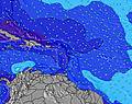 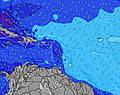 |  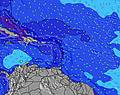 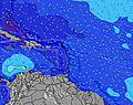 |   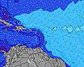 | 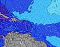 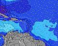 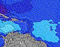 | ||||||||||||||||||||||||||||||||||||||||||||||||||||
| Wave Height (m) & direction (?) | ||||||||||||||||||||||||||||||||||||||||||||||||||||||||||||
| Period(s) (?) | 12 | 11 | 11 | 7 | 7 | 7 | 7 | 7 | 7 | 7 | 7 | 11 | 10 | 10 | 10 | 10 | 10 | 10 | 10 | 10 | 10 | 9 | 9 | 9 | 9 | 9 | 9 | 9 | 9 | 7 | 10 | 10 | 9 | 9 | 9 | 8 | 8 | 8 | 8 | 8 | 8 | 8 | 11 | 11 | 11 | 11 | 11 | 11 | 10 | 10 | 10 | 10 | 7 | 10 | 10 | 7 | 6 | 6 | 6 | 6 |
Wave (?)Graph | ||||||||||||||||||||||||||||||||||||||||||||||||||||||||||||
| Energy (?) | 224 | 205 | 188 | 179 | 217 | 236 | 239 | 209 | 176 | 176 | 146 | 366 | 294 | 267 | 286 | 245 | 296 | 245 | 220 | 240 | 192 | 180 | 282 | 365 | 338 | 286 | 268 | 232 | 213 | 318 | 424 | 524 | 505 | 803 | 542 | 771 | 920 | 956 | 952 | 897 | 897 | 916 | 748 | 698 | 606 | 514 | 449 | 441 | 432 | 340 | 284 | 284 | 255 | 230 | 225 | 189 | 181 | 207 | 188 | 212 |
Wind (km/h) | ||||||||||||||||||||||||||||||||||||||||||||||||||||||||||||
| Wind State (?) onshore cross-onshore cross-shore cross-offshore offshore glassy | cross- off | cross- off | cross- off | cross- off | cross- off | cross- off | cross- off | cross- off | cross- off | cross- off | cross- off | cross- off | cross | cross | cross- off | cross | cross | cross | cross | cross- off | cross- off | cross- off | cross- off | cross- off | cross- off | cross- off | cross- off | cross- off | cross- off | cross- off | cross- off | cross- off | cross- off | cross- off | cross- off | cross- off | cross- off | cross- off | cross- off | cross- off | cross- off | cross- off | cross- off | cross- off | cross- off | cross- off | cross- off | cross- off | cross- off | cross- off | cross- off | cross- off | cross- off | cross- off | cross- off | cross- off | cross- off | cross- off | cross- off | cross- off |
High Tide / height (m) | 2:47AM 0.43 | 10:28PM 0.50 | 11:49PM 0.51 | 1:09AM 0.51 | 2:01AM 0.51 | 2:29AM 0.49 | 2:47AM 0.46 | 12:26PM 0.36 | 3:00AM 0.43 | |||||||||||||||||||||||||||||||||||||||||||||||||||
Low Tide / height (m) | 3:22AM 0.43 | 2:01PM -0.03 | 2:49PM -0.04 | 3:44PM -0.04 | 4:47PM -0.03 | 5:56PM -0.01 | 7:08PM 0.03 | 9:47AM 0.34 | 8:19PM 0.09 | 9:37AM 0.25 | ||||||||||||||||||||||||||||||||||||||||||||||||||
Friday 26 | Saturday 27 | Sunday 28 | Monday 29 | Tuesday 30 | Wednesday 01 | Thursday 02 | Friday 03 | |||||||||||||||||||||||||||||||||||||||||||||||||||||
| Sunrise | - | 5:47 | - | - | - | - | - | - | - | 5:46 | - | - | - | - | - | - | - | 5:46 | - | - | - | - | - | - | - | 5:45 | - | - | - | - | - | - | - | 5:45 | - | - | - | - | - | - | - | 5:43 | - | - | - | - | - | - | - | 5:43 | - | - | - | - | - | - | - | 5:43 | - | - |
| Sunset | - | - | - | - | 6:30 | - | - | - | - | - | - | - | 6:30 | - | - | - | - | - | - | - | 6:30 | - | - | - | - | - | - | - | 6:30 | - | - | - | - | - | - | - | 6:31 | - | - | - | - | - | - | - | 6:31 | - | - | - | - | - | - | - | 6:31 | - | - | - | - | - | - | - |
Rain (mm) | - | 1 | - | 1 | - | - | - | - | - | - | - | - | - | - | 1 | 2 | 1 | 1 | 1 | - | 1 | - | - | 1 | 2 | 1 | 1 | 1 | - | 1 | 1 | 1 | - | 1 | - | - | 1 | 1 | 1 | 1 | 1 | 1 | - | 1 | 1 | 1 | 1 | 1 | 1 | 1 | - | 1 | 4 | 3 | 2 | 1 | 1 | 2 | 2 | 1 |
| Temp. °C | 26 | 26 | 26 | 26 | 27 | 26 | 26 | 26 | 26 | 26 | 26 | 27 | 26 | 26 | 26 | 25 | 26 | 26 | 26 | 26 | 26 | 25 | 25 | 25 | 25 | 25 | 25 | 25 | 25 | 25 | 25 | 25 | 26 | 26 | 26 | 26 | 26 | 25 | 25 | 25 | 25 | 26 | 26 | 26 | 26 | 26 | 26 | 26 | 26 | 27 | 27 | 27 | 26 | 25 | 25 | 25 | 25 | 25 | 26 | 26 |
| Feels °C (?) | 26 | 26 | 26 | 25 | 26 | 24 | 24 | 25 | 25 | 25 | 26 | 27 | 26 | 27 | 27 | 25 | 25 | 26 | 26 | 26 | 26 | 24 | 23 | 24 | 24 | 24 | 24 | 24 | 24 | 23 | 22 | 22 | 23 | 24 | 24 | 24 | 25 | 23 | 24 | 24 | 24 | 25 | 25 | 26 | 26 | 26 | 26 | 26 | 26 | 27 | 27 | 28 | 26 | 23 | 23 | 22 | 23 | 23 | 26 | 27 |
FREE! Surf-Forecast.com widget for your website
The surf report / weather widget below is available to embed on third party websites free of charge and provides a summary of our Lorient surf forecast. Simply grab the html code snippet that we provide and paste it into your own site. You can choose your preferred language and metric/imperial units for the surf forecast feed to suit users of your site. Click here to get the code.


 Nearest