

- Forecast
- Maps
- Live
- Weather State
- Spot Information

Surf Forecasts
Beach
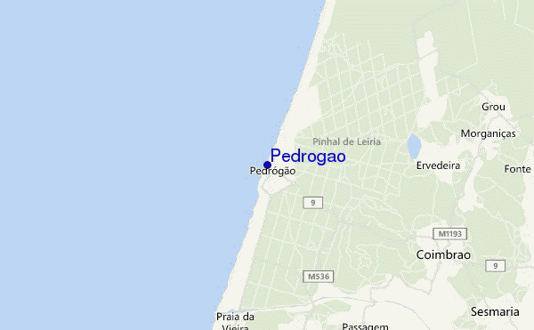
Pedrogao surf Forecast / Beira / Portugal
48hr Weather and Surf, issued 6 pm Friday 26 Apr 2024 WEST
Forecast update in hr min s Update imminent
Pedrogao surf forecast is for near shore open water. Breaking waves will often be smaller at less exposed spots.
Today's Pedrogao sea temperature is 16.7°C (Statistics for 26 Apr 1981-2005 - mean: 15.5 °C max: 18.0 °C min: 14.1 °C)
- Map Icons:
 Break
Break Live Wave Height (m)
 Live Wind Speed (km/h)
 Surf Rating (10 Max)
 Ocean Swells (m)
- Wind Speed (km/h)
Pedrogao surf forecast is for near shore open water. Breaking waves will often be smaller at less exposed spots.
Today's Pedrogao sea temperature is 16.7°C (Statistics for 26 Apr 1981-2005 - mean: 15.5 °C max: 18.0 °C min: 14.1 °C)
How big are the waves at Pedrogao today?
The current surf forecast for Pedrogao at 8PM is: 1.6m 10s primary swell from a Northwest direction and 1.0m 4s secondary swell from a West-southwest direction (forecast issued at 06:00pm April 26). The wind direction is predicted to be cross-onshore.
| Time (WEST) & Date | Wave Height | Wave Period |
|---|---|---|
| Morning (26 Apr) | - | - |
| Afternoon (26 Apr) | 5ft (1.6m) | 8s |
| Evening (26 Apr) | 6.5ft (2.0m) | 10s |
Table - waves today at Pedrogao. (Swell directed towards the surf break)
 Recent Eyeball Surf Reports for Beira
Expand
<
>
View all
Updates in hr min s Update imminent
Friday 26 | Saturday 27 | Sunday 28 | Monday 29 | Tuesday 30 | Wednesday 01 | Thursday 02 | Friday 03 | Sat 04 | ||||||||||||||||||||||||||||||||||||||||||||||||||||
| 4 PM | 7 PM | 10 PM | 1 AM | 4 AM | 7 AM | 10 AM | 1 PM | 4 PM | 7 PM | 10 PM | 1 AM | 4 AM | 7 AM | 10 AM | 1 PM | 4 PM | 7 PM | 10 PM | 1 AM | 4 AM | 7 AM | 10 AM | 1 PM | 4 PM | 7 PM | 10 PM | 1 AM | 4 AM | 7 AM | 10 AM | 1 PM | 4 PM | 7 PM | 10 PM | 1 AM | 4 AM | 7 AM | 10 AM | 1 PM | 4 PM | 7 PM | 10 PM | 1 AM | 4 AM | 7 AM | 10 AM | 1 PM | 4 PM | 7 PM | 10 PM | 1 AM | 4 AM | 7 AM | 10 AM | 1 PM | 4 PM | 7 PM | 10 PM | 1 AM | |
Rating (10 max) | ||||||||||||||||||||||||||||||||||||||||||||||||||||||||||||
Swell Height Map |    |    |    |    |    |    |    |    |    | |||||||||||||||||||||||||||||||||||||||||||||||||||
| Wave Height (m) & direction (?) | ||||||||||||||||||||||||||||||||||||||||||||||||||||||||||||
| Period(s) (?) | 8 | 10 | 10 | 10 | 9 | 10 | 13 | 13 | 13 | 12 | 12 | 12 | 12 | 11 | 11 | 10 | 10 | 10 | 9 | 9 | 9 | 8 | 9 | 8 | 8 | 8 | 8 | 8 | 8 | 8 | 7 | 7 | 7 | 8 | 8 | 8 | 8 | 8 | 8 | 9 | 9 | 11 | 11 | 11 | 11 | 11 | 12 | 12 | 12 | 12 | 12 | 11 | 11 | 11 | 10 | 10 | 10 | 10 | 9 | 9 |
Wave (?)Graph | ||||||||||||||||||||||||||||||||||||||||||||||||||||||||||||
| Energy (?) | 383 | 432 | 748 | 800 | 784 | 904 | 2510 | 3436 | 3341 | 2563 | 1920 | 1739 | 1546 | 1232 | 1132 | 954 | 869 | 876 | 854 | 823 | 769 | 616 | 516 | 392 | 311 | 273 | 211 | 182 | 138 | 131 | 138 | 256 | 319 | 383 | 402 | 372 | 422 | 466 | 504 | 500 | 739 | 1326 | 1388 | 1484 | 1609 | 1775 | 1757 | 1678 | 1521 | 1372 | 1348 | 1172 | 990 | 828 | 721 | 569 | 507 | 398 | 300 | 287 |
Wind (km/h) | ||||||||||||||||||||||||||||||||||||||||||||||||||||||||||||
| Wind State (?) onshore cross-onshore cross-shore cross-offshore offshore glassy | cross- on | cross- on | cross- on | cross- on | cross | cross- on | cross- on | cross- on | cross- on | on | on | on | cross- on | cross- on | cross- on | cross- on | cross- on | cross- on | cross- on | cross- on | cross- on | cross- on | cross- on | cross- on | cross- on | on | on | cross- on | cross- on | cross- on | cross- on | on | cross- on | on | on | on | on | on | on | on | on | on | on | on | on | cross- on | cross- on | cross- on | cross- on | cross | cross | cross- off | cross- off | cross- off | cross- off | cross | cross | cross | cross- on | cross- on |
High Tide / height (m) | 5:02PM 2.76 | 5:21AM 2.60 | 5:37PM 2.67 | 6:00AM 2.46 | 6:18PM 2.55 | 6:46AM 2.32 | 7:10PM 2.43 | 7:47AM 2.18 | 8:17PM 2.34 | 9:07AM 2.10 | 9:38PM 2.34 | 10:34AM 2.15 | 10:58PM 2.45 | 11:47AM 2.32 | 12:05AM 2.65 | |||||||||||||||||||||||||||||||||||||||||||||
Low Tide / height (m) | 11:12PM 0.38 | 11:23AM 0.47 | 11:49PM 0.49 | 12:01PM 0.60 | 12:34AM 0.62 | 12:47PM 0.74 | 1:30AM 0.74 | 1:47PM 0.87 | 2:45AM 0.81 | 3:07PM 0.93 | 4:13AM 0.76 | 4:34PM 0.87 | 5:30AM 0.59 | 5:47PM 0.71 | ||||||||||||||||||||||||||||||||||||||||||||||
Friday 26 | Saturday 27 | Sunday 28 | Monday 29 | Tuesday 30 | Wednesday 01 | Thursday 02 | Friday 03 | Sat 04 | ||||||||||||||||||||||||||||||||||||||||||||||||||||
| Sunrise | - | - | - | - | - | 6:39 | - | - | - | - | - | - | - | 6:39 | - | - | - | - | - | - | - | 6:37 | - | - | - | - | - | - | - | 6:35 | - | - | - | - | - | - | - | 6:35 | - | - | - | - | - | - | - | 6:33 | - | - | - | - | - | - | - | 6:33 | - | - | - | - | - | - |
| Sunset | - | 8:24 | - | - | - | - | - | - | - | 8:25 | - | - | - | - | - | - | - | 8:27 | - | - | - | - | - | - | - | 8:28 | - | - | - | - | - | - | - | 8:29 | - | - | - | - | - | - | - | 8:30 | - | - | - | - | - | - | - | 8:30 | - | - | - | - | - | - | - | 8:31 | - | - |
Rain (mm) | 1 | 1 | 4 | 1 | 1 | 3 | - | - | 1 | - | 1 | - | 1 | 2 | 1 | 1 | - | - | - | - | - | - | - | - | - | - | - | - | 2 | 2 | 2 | 2 | 1 | 1 | 1 | - | - | 1 | 1 | 1 | 1 | 1 | 1 | 1 | 1 | 1 | - | - | - | - | - | - | - | - | - | - | 1 | 2 | 4 | 1 |
| Temp. °C | 15 | 14 | 12 | 13 | 12 | 10 | 13 | 14 | 14 | 14 | 13 | 12 | 12 | 11 | 12 | 14 | 14 | 14 | 13 | 13 | 13 | 12 | 13 | 14 | 14 | 14 | 14 | 14 | 14 | 15 | 15 | 15 | 15 | 14 | 13 | 14 | 13 | 12 | 13 | 13 | 14 | 13 | 13 | 12 | 12 | 13 | 14 | 14 | 15 | 15 | 14 | 13 | 12 | 12 | 15 | 17 | 17 | 16 | 15 | 15 |
| Feels °C (?) | 9 | 8 | 6 | 6 | 5 | 1 | 8 | 8 | 8 | 9 | 7 | 7 | 7 | 6 | 8 | 9 | 8 | 8 | 7 | 7 | 7 | 7 | 8 | 9 | 10 | 10 | 12 | 11 | 11 | 12 | 11 | 11 | 11 | 8 | 7 | 7 | 8 | 7 | 7 | 6 | 8 | 7 | 8 | 7 | 8 | 10 | 11 | 9 | 9 | 10 | 10 | 9 | 7 | 6 | 8 | 10 | 10 | 9 | 11 | 10 |
FREE! Surf-Forecast.com widget for your website
The surf report / weather widget below is available to embed on third party websites free of charge and provides a summary of our Pedrogao surf forecast. Simply grab the html code snippet that we provide and paste it into your own site. You can choose your preferred language and metric/imperial units for the surf forecast feed to suit users of your site. Click here to get the code.


 Nearest