
Golfvoorspellingen:

Voorspelling Lange TermijnZware regen (totaal 49mm), zwaarst tijdens dinsdagavond. Warm (max 28°C op maandagmiddag, min 26°C op maandagavond). Wind zal licht zijn over het algemeen. | ||||||||||||||||||||||||
Monday 20 | Tuesday 21 | Wednesday 22 | ||||||||||||||||||||||
1 AM | 4 AM | 7 AM | 10 AM | 1 PM | 4 PM | 7 PM | 10 PM | 1 AM | 4 AM | 7 AM | 10 AM | 1 PM | 4 PM | 7 PM | 10 PM | 1 AM | 4 AM | 7 AM | 10 AM | 1 PM | 4 PM | 7 PM | 10 PM | |
Golfhoogte kaart |  | 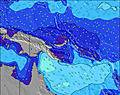 | 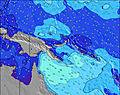 | 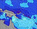 | 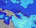 | 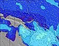 | 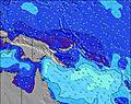 | 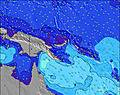 | 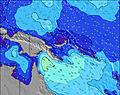 | |||||||||||||||
Golf Hoogte (m) Richting Periode (s) | N 8 | NE 6 | NW 6 | NW 6 | NW 7 | NE 8 | NNW 7 | NNW 7 | NNW 6 | NNW 6 | NNW 6 | NNW 6 | NNW 6 | NNW 6 | N 8 | N 8 | N 8 | N 7 | NE 9 | NE 9 | NW 6 | NW 6 | N 7 | N 7 |
Golf Grafiek | ||||||||||||||||||||||||
2 | 2 | 2 | 2 | 2 | 2 | 5 | 4 | 4 | 4 | 4 | 3 | 3 | 4 | 1 | 2 | 2 | 2 | 3 | 3 | 1 | 1 | 1 | 1 | |
Wind (km/h) | ||||||||||||||||||||||||
Wind onshore cross-onshore cross-shore cross-offshore offshore glasachtig | cross-off | cross-off | cross-off | cross-off | cross-off | cross-off | cross-off | cross-off | cross-off | cross-off | cross | cross-off | cross-off | cross-off | cross-off | cross-off | cross-off | cross-off | cross | cross-off | cross-off | cross-off | cross-off | cross-off |
Vloed | 00:03AM1.15m | 12:21PM0.87m | 00:33AM1.13m | 1:58PM0.84m | 1:03AM1.11m | 3:40PM0.85m | ||||||||||||||||||
Eb | 6:49AM0.53m | 5:54PM0.56m | 7:46AM0.44m | 6:38PM0.68m | 8:38AM0.37m | 7:27PM0.78m | ||||||||||||||||||
— | 6:33 | — | — | — | — | — | — | — | 6:33 | — | — | — | — | — | — | — | 6:33 | — | — | — | — | — | — | |
— | — | — | — | — | 6:31 | — | — | — | — | — | — | — | 6:31 | — | — | — | — | — | — | — | 6:31 | — | — | |
mm | 1 | 2 | 2 | 1 | — | — | — | 1 | 1 | 4 | 2 | 1 | — | — | — | — | 3 | 7 | 2 | 2 | 1 | 1 | 1 | 4 |
Temp. °C | 27 | 27 | 26 | 27 | 27 | 27 | 28 | 28 | 27 | 26 | 26 | 27 | 27 | 27 | 27 | 27 | 26 | 26 | 26 | 27 | 27 | 27 | 27 | 27 |
Chill °C | 27 | 28 | 27 | 29 | 28 | 28 | 30 | 30 | 29 | 28 | 28 | 29 | 29 | 30 | 30 | 29 | 28 | 28 | 28 | 29 | 29 | 29 | 29 | 29 |
Swell 1 Hoogte (m) Richting Periode (s) | ENE 9 | ENE 9 | E 6 | E 6 | ENE 9 | ENE 9 | NNW 7 | NNW 7 | NNW 6 | NNW 6 | E 6 | E 6 | E 6 | E 7 | NW 6 | NW 6 | ENE 9 | ENE 9 | NW 6 | E 6 | E 6 | ENE 9 | ENE 9 | ENE 9 |
8 | 8 | 31 | 22 | 8 | 8 | 5 | 4 | 4 | 4 | 33 | 36 | 41 | 32 | 1 | 2 | 8 | 9 | 1 | 41 | 41 | 8 | 8 | 8 | |
Swell 2 Hoogte (m) Richting Periode (s) | N 8 | NE 6 | ENE 9 | ENE 9 | NW 7 | NW 7 | ENE 9 | ENE 9 | ENE 9 | ENE 9 | NNW 6 | NNW 6 | ENE 9 | NNW 6 | ENE 9 | ENE 9 | NW 6 | NW 6 | NE 9 | NE 9 | ENE 9 | NW 6 | NW 6 | NW 6 |
1 | 2 | 8 | 8 | 2 | 2 | 8 | 8 | 8 | 8 | 4 | 3 | 8 | 4 | 8 | 8 | 2 | 2 | 3 | 3 | 8 | 1 | 1 | 1 | |
Swell 3 Hoogte (m) Richting Periode (s) | NW 7 | N 6 | NW 6 | NW 6 | NE 6 | NE 8 | N 8 | NE 6 | N 8 | N 8 | ENE 9 | ENE 9 | NNW 6 | ENE 9 | N 8 | N 8 | N 8 | N 7 | N 8 | NW 6 | NW 6 | — | N 7 | N 7 |
2 | 1 | 2 | 2 | 1 | 2 | 1 | 1 | 1 | 1 | 8 | 8 | 3 | 8 | 1 | 1 | 1 | 1 | 1 | 1 | 1 | — | 1 | 1 | |
Windgolven Hoogte (m) Richting Periode (s) | E 6 | E 6 | E 6 | — | E 6 | E 6 | E 6 | E 6 | E 7 | E 7 | E 6 | — | — | — | E 7 | E 7 | E 7 | E 7 | E 6 | E 7 | E 6 | E 6 | E 6 | E 6 |
41 | 42 | 54 | — | 23 | 23 | 24 | 29 | 33 | 42 | 58 | — | — | — | 32 | 32 | 32 | 42 | 41 | 70 | 68 | 27 | 27 | 36 | |
Dichtstbijzijnd Glasachtig of Offshore | ||||||||||||||||||||||||
Afstand (km) | 1838 | 57 | 57 | 40 | 1863 | 1838 | 1848 | 1847 | 1841 | 1864 | 1864 | 2489 | 1838 | 1838 | 2382 | 1838 | 1838 | 1838 | 1838 | 1838 | 974 | 2783 | 2489 | 2489 |
Beste voorspelde golfomstandigheden in East Sepik | ||||||||||||||||||||||||
Beste voorspelde golfomstandigheden in Papua New Guinea | ||||||||||||||||||||||||
Wereldwijde Golfzoeker | ||||||||||||||||||||||||
- Map Icons:
 Break
Break Live Wave Height (m)
 Live Wind Speed (km/h)
 Surf Rating (10 Max)
 Ocean Swells (m)
- Wind Speed (km/h)
GRATIS Surf-Forecast.com widget voor je website
Het gratis surfbericht/weer widget hieronder is beschikbaar voor websites en geeft een samenvatting van de golfvoorspelling voor Tarawai. Kopieer de HTML-code en plak deze in je eigen site. Je kunt je eigen voorkeurstaal en eenheden kiezen zodat de voorspelling afgesteld is op de gebruikers van jouw site. Klik hier voor de code.
 Nearest