
Golfvoorspellingen:

Voorspelling Lange TermijnWat motregen, zwaarste tijdens woensdagavond. Warm (max 25°C op donderdagochtend, min 23°C op woensdagavond). Voornamelijk sterke wind. | ||||||||||||||||||||||||
Wednesday 15 | Thursday 16 | Friday 17 | Sat 18 | |||||||||||||||||||||
4 AM | 7 AM | 10 AM | 1 PM | 4 PM | 7 PM | 10 PM | 1 AM | 4 AM | 7 AM | 10 AM | 1 PM | 4 PM | 7 PM | 10 PM | 1 AM | 4 AM | 7 AM | 10 AM | 1 PM | 4 PM | 7 PM | 10 PM | 1 AM | |
Golfhoogte kaart |  |  |  |  | 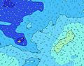 |  |  | 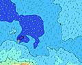 |  | 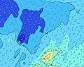 | ||||||||||||||
Golf Hoogte (m) Richting Periode (s) | SSE 8 | SSE 8 | SE 8 | SE 8 | SSE 8 | SE 8 | SE 8 | SE 8 | SE 8 | SE 8 | SE 8 | SE 8 | SE 8 | SE 8 | SE 8 | SE 9 | SE 9 | SE 9 | SSE 16 | SSE 16 | SSE 15 | SE 8 | SE 8 | SE 8 |
Golf Grafiek | ||||||||||||||||||||||||
649 | 634 | 653 | 804 | 941 | 981 | 844 | 816 | 769 | 857 | 834 | 774 | 865 | 1082 | 1339 | 1405 | 1306 | 1129 | 1067 | 1040 | 962 | 984 | 1039 | 962 | |
Wind (km/h) | ||||||||||||||||||||||||
Wind onshore cross-onshore cross-shore cross-offshore offshore glasachtig | cross-off | cross-off | cross-off | cross-off | cross-off | cross-off | cross-off | cross-off | cross-off | cross-off | cross-off | cross-off | cross-off | cross-off | cross-off | cross-off | cross-off | cross-off | cross-off | cross-off | cross-off | cross-off | cross-off | cross-off |
Vloed | 7:48AM1.20m | 8:24PM1.04m | 8:42AM1.15m | 9:18PM1.03m | 9:37AM1.09m | 10:13PM1.00m | ||||||||||||||||||
Eb | 1:28AM0.05m | 2:11PM-0.01m | 2:23AM0.08m | 3:04PM0.03m | 3:20AM0.12m | 3:56PM0.09m | ||||||||||||||||||
6:48 | — | — | — | — | — | — | — | 6:48 | — | — | — | — | — | — | — | 6:48 | — | — | — | — | — | — | 6:48 | |
— | — | — | — | 6:09 | — | — | — | — | — | — | — | 6:09 | — | — | — | — | — | — | — | 6:09 | — | — | 6:09 | |
mm | — | — | — | — | — | — | — | — | 1 | — | — | — | — | — | — | — | — | — | — | — | — | — | — | — |
Temp. °C | 24 | 24 | 24 | 24 | 24 | 24 | 24 | 24 | 23 | 24 | 25 | 25 | 25 | 24 | 23 | 23 | 23 | 23 | 23 | 24 | 24 | 24 | 24 | 23 |
Chill °C | 17 | 18 | 18 | 17 | 17 | 17 | 17 | 18 | 16 | 18 | 19 | 19 | 19 | 17 | 16 | 16 | 16 | 17 | 17 | 17 | 18 | 17 | 18 | 16 |
Swell 1 Hoogte (m) Richting Periode (s) | SW 14 | SW 14 | SW 14 | SW 13 | SW 13 | SW 13 | SW 13 | SW 13 | SSW 13 | SW 21 | SW 20 | SW 19 | SSE 19 | SSE 18 | SE 18 | SSE 17 | SSE 16 | SSE 16 | SSE 16 | SSE 16 | SSE 15 | SSE 15 | SSE 15 | SSE 14 |
99 | 97 | 67 | 63 | 44 | 28 | 27 | 28 | 35 | 150 | 325 | 296 | 455 | 553 | 703 | 798 | 818 | 969 | 1067 | 1040 | 962 | 924 | 857 | 742 | |
Swell 2 Hoogte (m) Richting Periode (s) | SSW 13 | SSW 13 | SSW 12 | SSW 12 | NNE 8 | SW 21 | SW 21 | SW 20 | SW 13 | SSW 13 | SSE 16 | SE 16 | SW 19 | SW 18 | SW 18 | SW 18 | SW 17 | SW 16 | SW 16 | SW 16 | SW 15 | SW 15 | SW 15 | SW 16 |
58 | 56 | 30 | 30 | 7 | 71 | 68 | 63 | 28 | 35 | 104 | 133 | 281 | 396 | 392 | 534 | 567 | 596 | 589 | 448 | 519 | 505 | 525 | 416 | |
Swell 3 Hoogte (m) Richting Periode (s) | NNE 8 | NNE 8 | S 16 | NNE 8 | SSW 21 | NW 14 | S 15 | S 14 | SW 20 | SE 16 | S 13 | SE 20 | SSW 12 | SSW 12 | SW 13 | SW 13 | W 14 | W 14 | NW 14 | W 13 | W 14 | — | — | — |
7 | 7 | 20 | 7 | 45 | 8 | 38 | 37 | 65 | 64 | 31 | 98 | 29 | 29 | 27 | 44 | 4 | 4 | 7 | 4 | 4 | — | — | — | |
Windgolven Hoogte (m) Richting Periode (s) | SSE 8 | SSE 8 | SE 8 | SE 8 | SSE 8 | SE 8 | SE 8 | SE 8 | SE 8 | SE 8 | SE 8 | SE 8 | SE 8 | SE 8 | SE 8 | SE 9 | SE 9 | SE 9 | SE 8 | SE 8 | SE 8 | SE 8 | SE 8 | SE 8 |
649 | 634 | 653 | 804 | 941 | 981 | 844 | 816 | 769 | 857 | 834 | 774 | 865 | 1082 | 1339 | 1405 | 1306 | 1129 | 953 | 824 | 844 | 984 | 1039 | 962 | |
Dichtstbijzijnd Glasachtig of Offshore | ||||||||||||||||||||||||
Afstand (km) | 1328 | 1328 | 1328 | 1328 | 1328 | 1328 | 1328 | 1328 | 1328 | 1328 | 1400 | 1328 | 1328 | 1328 | 1328 | 1335 | 1335 | 2386 | 1335 | 1328 | 1328 | 1405 | 1328 | 1328 |
Beste voorspelde golfomstandigheden in American-Samoa - Tutuila | ||||||||||||||||||||||||
Beste voorspelde golfomstandigheden in American Samoa | ||||||||||||||||||||||||
Wereldwijde Golfzoeker | ||||||||||||||||||||||||
- Map Icons:
 Break
Break Live Wave Height (m)
 Live Wind Speed (km/h)
 Surf Rating (10 Max)
 Ocean Swells (m)
- Wind Speed (km/h)
GRATIS Surf-Forecast.com widget voor je website
Het gratis surfbericht/weer widget hieronder is beschikbaar voor websites en geeft een samenvatting van de golfvoorspelling voor Amanave Bay. Kopieer de HTML-code en plak deze in je eigen site. Je kunt je eigen voorkeurstaal en eenheden kiezen zodat de voorspelling afgesteld is op de gebruikers van jouw site. Klik hier voor de code.
 Nearest