
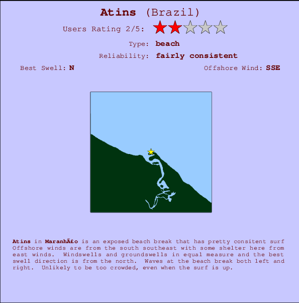
Atins Surf Guide
Atins in Maranhao is an exposed beach break that has fairly consistent surf The best wind direction is from the south southeast with some shelter here from east winds. Most of the surf here comes from groundswells and the best swell direction is from the north. The beach break offers both left and right hand waves. Even when there are waves, it's not likley to be crowded.
Atins Spot Info
| Type: | Rating: | Reliability: | Todays Sea Temp*: |
|---|---|---|---|
| fairly consistent | 28.3°C*ocean temperature recorded from satellite |
Surfing Atins:
The best conditions reported for surf at Atins occur when a North swell combines with an offshore wind direction from the South-southeast.
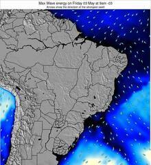
Voorspelde Golfenergie (Kracht): 12 uur


Atins Surf:
Saturday, 18 July 2026, 06:05 Local time| Saturday 18 | ||||
| 6AM | 9AM | 12PM | 3PM | |
| Wave (m) | ||||
| Periode (s) | 6 | 7 | 7 | 6 |
| Wind (km/h) | ||||
| Wind | cross- off |
cross- off |
cross- off |
cross |
- /breaks/Atins/forecasts/latest
Atins Surf Guide
Atins in Maranhao is an exposed beach break that has fairly consistent surf The best wind direction is from the south southeast with some shelter here from east winds. Most of the surf here comes from groundswells and the best swell direction is from the north. The beach break offers both left and right hand waves. Even when there are waves, it's not likley to be crowded.
Atins Spot Info
Type: Rating: Reliability: Todays Sea Temp*:  Beach
Beach 2
2fairly consistent 28.3°C*ocean temperature recorded from satelliteSurfing Atins:
The best conditions reported for surf at Atins occur when a North swell combines with an offshore wind direction from the South-southeast.
Voorspelde Golfenergie (Kracht): 12 uur
Gebruik de tabbladen hierboven om de zeewatertemperatuur bij Atins te bekijken, foto's van Atins, Atins gedetailleerde golfvoorspellingen, wind- en weersvoorspellingen, Atins webcams, actuele wind in Maranhao live weerstations en Atins getijdenvoorspellingen. De link van Brazil golfkaarten opent een grote afbeelding van Brazil en de omliggende zeeën. Deze golfkaarten kunnen worden dynamisch gemaakt worden met de verschillende golfcomponenten, golfenergie, golfperiode, golfhoogte, samen met de wind en weersvoorspellingen, het actuele weer en de zeetoestand volgens golfboeien uit Brazil, langskomende schepen en weerstations op de kust. Elk voorspelling pagina's voor dit surfstrand zijn voorzien van een wereldwijde en regionale golfzoeker om de beste surfsomstandigheden in het gebied rond Atins te vinden.
Atins Surf:
Saturday, 18 July 2026, 06:05 Local timeSaturday 18 6AM 9AM 12PM 3PM Wave (m) Periode (s) 6 7 7 6 Wind (km/h) Wind cross-
offcross-
offcross-
offcross - /breaks/Atins/forecasts/latest
- /breaks/Atins/forecasts/latest/six_day
Atins Surf Guide
Atins in Maranhao is an exposed beach break that has fairly consistent surf The best wind direction is from the south southeast with some shelter here from east winds. Most of the surf here comes from groundswells and the best swell direction is from the north. The beach break offers both left and right hand waves. Even when there are waves, it's not likley to be crowded.
Atins Spot Info
Type: Rating: Reliability: Todays Sea Temp*: Beach2fairly consistent 28.3°C*ocean temperature recorded from satelliteSurfing Atins:
The best conditions reported for surf at Atins occur when a North swell combines with an offshore wind direction from the South-southeast.
Voorspelde Golfenergie (Kracht): 12 uur
Gebruik de tabbladen hierboven om de zeewatertemperatuur bij Atins te bekijken, foto's van Atins, Atins gedetailleerde golfvoorspellingen, wind- en weersvoorspellingen, Atins webcams, actuele wind in Maranhao live weerstations en Atins getijdenvoorspellingen. De link van Brazil golfkaarten opent een grote afbeelding van Brazil en de omliggende zeeën. Deze golfkaarten kunnen worden dynamisch gemaakt worden met de verschillende golfcomponenten, golfenergie, golfperiode, golfhoogte, samen met de wind en weersvoorspellingen, het actuele weer en de zeetoestand volgens golfboeien uit Brazil, langskomende schepen en weerstations op de kust. Elk voorspelling pagina's voor dit surfstrand zijn voorzien van een wereldwijde en regionale golfzoeker om de beste surfsomstandigheden in het gebied rond Atins te vinden.
Atins Surf:
Saturday, 18 July 2026, 06:05 Local timeSaturday 18 6AM 9AM 12PM 3PM Wave (m) Periode (s) 6 7 7 6 Wind (km/h) Wind cross-
offcross-
offcross-
offcross - /breaks/Atins/forecasts/latest
Atins Surf Guide
Atins in Maranhao is an exposed beach break that has fairly consistent surf The best wind direction is from the south southeast with some shelter here from east winds. Most of the surf here comes from groundswells and the best swell direction is from the north. The beach break offers both left and right hand waves. Even when there are waves, it's not likley to be crowded.
Atins Spot Info
Type: Rating: Reliability: Todays Sea Temp*: Beach2fairly consistent 28.3°C*ocean temperature recorded from satelliteSurfing Atins:
The best conditions reported for surf at Atins occur when a North swell combines with an offshore wind direction from the South-southeast.
Voorspelde Golfenergie (Kracht): 12 uur
Gebruik de tabbladen hierboven om de zeewatertemperatuur bij Atins te bekijken, foto's van Atins, Atins gedetailleerde golfvoorspellingen, wind- en weersvoorspellingen, Atins webcams, actuele wind in Maranhao live weerstations en Atins getijdenvoorspellingen. De link van Brazil golfkaarten opent een grote afbeelding van Brazil en de omliggende zeeën. Deze golfkaarten kunnen worden dynamisch gemaakt worden met de verschillende golfcomponenten, golfenergie, golfperiode, golfhoogte, samen met de wind en weersvoorspellingen, het actuele weer en de zeetoestand volgens golfboeien uit Brazil, langskomende schepen en weerstations op de kust. Elk voorspelling pagina's voor dit surfstrand zijn voorzien van een wereldwijde en regionale golfzoeker om de beste surfsomstandigheden in het gebied rond Atins te vinden.
Atins Surf:
Saturday, 18 July 2026, 06:05 Local timeSaturday 18 6AM 9AM 12PM 3PM Wave (m) Periode (s) 6 7 7 6 Wind (km/h) Wind cross-
offcross-
offcross-
offcross Tide Times:
Op Atins (0 km).
VOLGENDE IS OM (lokale tijd) resterende tijd hoog water laag water Atins Tide Times and Tide Chart
Live Weather:
At Preguicas, 4 km from Atins.
-
no reportAir temperature
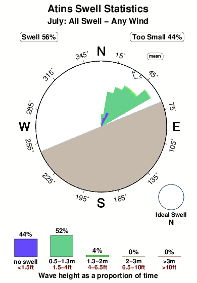
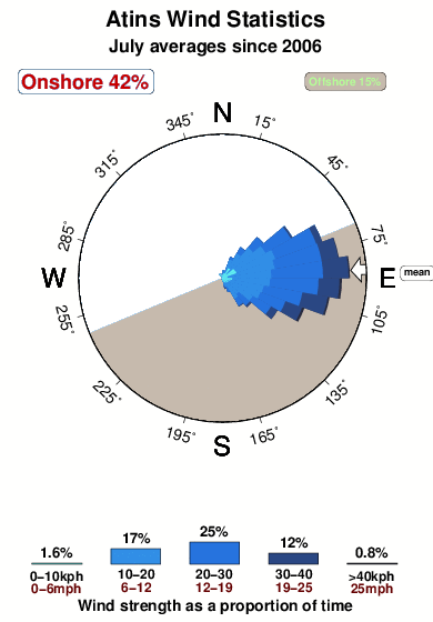
27.4°COverall Atins Surf Consistency and Wind Distribution in July
surffoto's uit
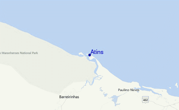
de galerijContourlijnen: Wegen & Rivieren: Kies een surflokatie uit het menu 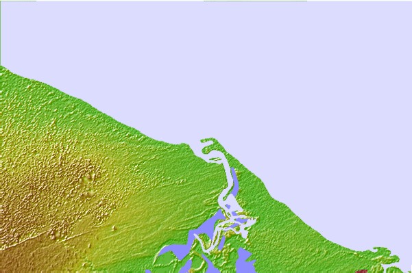

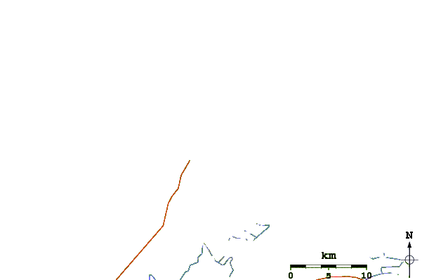
Gebruik deze reliëfkaart om naar de surfspots en de getijdenstations van Maranhao toe te gaan, in de buurt van Atins.
Andere Dichtbijzijnde Surflocaties van Atins:
(klik op locatienaam voor meer informatie)- Closest Locatie66 mi
- Second closest Locatie70 mi
- Third closest Locatie71 mi
- Fourth closest Locatie80 mi
- Fifth closest Locatie82 mi
Dichtstbijzijnde golfboeien bij Atins:
- Closest golfboei1191 mi
- Second closest golfboei1372 mi
- Third closest golfboei1503 mi
- Fourth closest golfboei1936 mi
- Fifth closest golfboei1992 mi
Getijdenstations in de buurt van Atins:
- Closest getijdenstationBaia da Tutoia37 mi
- Second closest getijdenstationTutoia37 mi
- Third closest getijdenstationHumberto de Campos51 mi
- Fourth closest getijdenstationSantana, Recifes de63 mi
- Fifth closest getijdenstationLuis Correia76 mi
Airports
- The nearest passenger airport to Atins is Marechal Cunha Machado (Sao Luis) Airport (SLZ) in Brazil, which is 168 km (104 miles) away (directly).
- The second closest airport to Atins is Senador Petronio Portella (Teresina) Airport (THE), also in Brazil, 278 km (173 miles) away.
- /breaks/Atins/forecasts/latest


 Nearest