

Baylys Beach Surf Guide
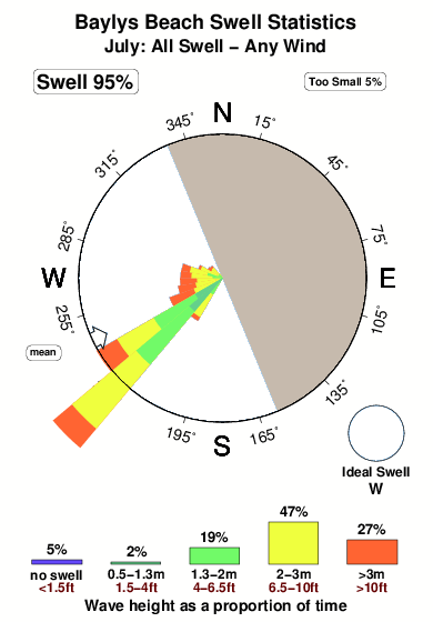
Baylys Beach in Northland is an exposed beach break that has unreliable waves The best wind direction is from the east northeast. Groundswells more frequent than windswells and the best swell direction is from the west. Waves at the beach break both left and right. Even when there are waves, it's not likley to be crowded. Hazards include - Rips / undertow.
Baylys Beach Spot Info
| Type: | Rating: | Reliability: | Todays Sea Temp*: |
|---|---|---|---|
| inconsistent | 14.7°C*ocean temperature recorded from satellite |
Surfing Baylys Beach:
The best conditions reported for surf at Baylys Beach occur when a West swell combines with an offshore wind direction from the East-northeast.

Voorspelde Golfenergie (Kracht): 12 uur


Baylys Beach Surf:
Tuesday, 28 July 2026, 17:13 Local time| Tuesday 28 | Wed | |||
| 3PM | 6PM | 9PM | 0AM | |
| Wave (m) | ||||
| Periode (s) | 12 | 12 | 11 | 11 |
| Wind (km/h) | ||||
| Wind | cross- on |
cross | cross- off |
off |
- /breaks/Baylys-Beach/forecasts/latest
Baylys Beach Surf Guide
Baylys Beach in Northland is an exposed beach break that has unreliable waves The best wind direction is from the east northeast. Groundswells more frequent than windswells and the best swell direction is from the west. Waves at the beach break both left and right. Even when there are waves, it's not likley to be crowded. Hazards include - Rips / undertow.
Baylys Beach Spot Info
Type: Rating: Reliability: Todays Sea Temp*:  Beach
Beach 2
2inconsistent 14.7°C*ocean temperature recorded from satelliteSurfing Baylys Beach:
The best conditions reported for surf at Baylys Beach occur when a West swell combines with an offshore wind direction from the East-northeast.
Voorspelde Golfenergie (Kracht): 12 uur
Gebruik de tabbladen hierboven om de zeewatertemperatuur bij Baylys Beach te bekijken, foto's van Baylys Beach, Baylys Beach gedetailleerde golfvoorspellingen, wind- en weersvoorspellingen, Baylys Beach webcams, actuele wind in Northland live weerstations en Baylys Beach getijdenvoorspellingen. De link van New Zealand golfkaarten opent een grote afbeelding van New Zealand en de omliggende zeeën. Deze golfkaarten kunnen worden dynamisch gemaakt worden met de verschillende golfcomponenten, golfenergie, golfperiode, golfhoogte, samen met de wind en weersvoorspellingen, het actuele weer en de zeetoestand volgens golfboeien uit New Zealand, langskomende schepen en weerstations op de kust. Elk voorspelling pagina's voor dit surfstrand zijn voorzien van een wereldwijde en regionale golfzoeker om de beste surfsomstandigheden in het gebied rond Baylys Beach te vinden.
Baylys Beach Surf:
Tuesday, 28 July 2026, 17:13 Local timeTuesday 28 Wed 3PM 6PM 9PM 0AM Wave (m) Periode (s) 12 12 11 11 Wind (km/h) Wind cross-
oncross cross-
offoff - /breaks/Baylys-Beach/forecasts/latest
- /breaks/Baylys-Beach/forecasts/latest/six_day
Baylys Beach Surf Guide
Baylys Beach in Northland is an exposed beach break that has unreliable waves The best wind direction is from the east northeast. Groundswells more frequent than windswells and the best swell direction is from the west. Waves at the beach break both left and right. Even when there are waves, it's not likley to be crowded. Hazards include - Rips / undertow.
Baylys Beach Spot Info
Type: Rating: Reliability: Todays Sea Temp*: Beach2inconsistent 14.7°C*ocean temperature recorded from satelliteSurfing Baylys Beach:
The best conditions reported for surf at Baylys Beach occur when a West swell combines with an offshore wind direction from the East-northeast.
Voorspelde Golfenergie (Kracht): 12 uur
Gebruik de tabbladen hierboven om de zeewatertemperatuur bij Baylys Beach te bekijken, foto's van Baylys Beach, Baylys Beach gedetailleerde golfvoorspellingen, wind- en weersvoorspellingen, Baylys Beach webcams, actuele wind in Northland live weerstations en Baylys Beach getijdenvoorspellingen. De link van New Zealand golfkaarten opent een grote afbeelding van New Zealand en de omliggende zeeën. Deze golfkaarten kunnen worden dynamisch gemaakt worden met de verschillende golfcomponenten, golfenergie, golfperiode, golfhoogte, samen met de wind en weersvoorspellingen, het actuele weer en de zeetoestand volgens golfboeien uit New Zealand, langskomende schepen en weerstations op de kust. Elk voorspelling pagina's voor dit surfstrand zijn voorzien van een wereldwijde en regionale golfzoeker om de beste surfsomstandigheden in het gebied rond Baylys Beach te vinden.
Baylys Beach Surf:
Tuesday, 28 July 2026, 17:13 Local timeTuesday 28 Wed 3PM 6PM 9PM 0AM Wave (m) Periode (s) 12 12 11 11 Wind (km/h) Wind cross-
oncross cross-
offoff - /breaks/Baylys-Beach/forecasts/latest
Baylys Beach Surf Guide
Baylys Beach in Northland is an exposed beach break that has unreliable waves The best wind direction is from the east northeast. Groundswells more frequent than windswells and the best swell direction is from the west. Waves at the beach break both left and right. Even when there are waves, it's not likley to be crowded. Hazards include - Rips / undertow.
Baylys Beach Spot Info
Type: Rating: Reliability: Todays Sea Temp*: Beach2inconsistent 14.7°C*ocean temperature recorded from satelliteSurfing Baylys Beach:
The best conditions reported for surf at Baylys Beach occur when a West swell combines with an offshore wind direction from the East-northeast.
Voorspelde Golfenergie (Kracht): 12 uur
Gebruik de tabbladen hierboven om de zeewatertemperatuur bij Baylys Beach te bekijken, foto's van Baylys Beach, Baylys Beach gedetailleerde golfvoorspellingen, wind- en weersvoorspellingen, Baylys Beach webcams, actuele wind in Northland live weerstations en Baylys Beach getijdenvoorspellingen. De link van New Zealand golfkaarten opent een grote afbeelding van New Zealand en de omliggende zeeën. Deze golfkaarten kunnen worden dynamisch gemaakt worden met de verschillende golfcomponenten, golfenergie, golfperiode, golfhoogte, samen met de wind en weersvoorspellingen, het actuele weer en de zeetoestand volgens golfboeien uit New Zealand, langskomende schepen en weerstations op de kust. Elk voorspelling pagina's voor dit surfstrand zijn voorzien van een wereldwijde en regionale golfzoeker om de beste surfsomstandigheden in het gebied rond Baylys Beach te vinden.
Baylys Beach Surf:
Tuesday, 28 July 2026, 17:13 Local timeTuesday 28 Wed 3PM 6PM 9PM 0AM Wave (m) Periode (s) 12 12 11 11 Wind (km/h) Wind cross-
oncross cross-
offoff Tide Times:
Op Baylys Beach (0 km).
VOLGENDE IS OM (lokale tijd) resterende tijd hoog water laag water Baylys Beach Tide Times and Tide Chart
Live Weather:
At Mahuta, 1 km from Baylys Beach.
light winds from the S
(km/h)
DryAir temperature
14.6°COverall Baylys Beach Surf Consistency and Wind Distribution in July
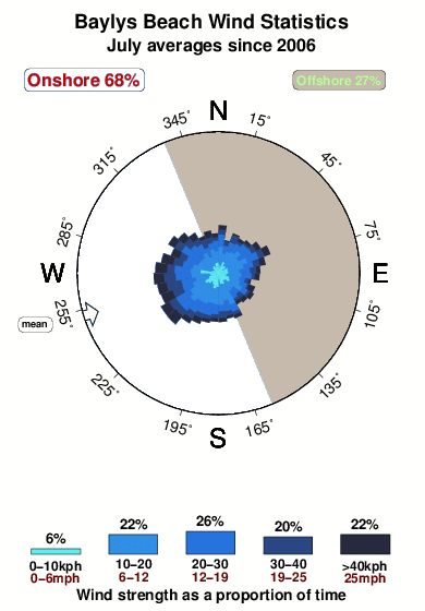


Wind stats for Baylys Beach: see the variation in direction and stength by month.
surffoto's uit
de galerijContourlijnen: Wegen & Rivieren: Kies een surflokatie uit het menu 


Gebruik deze reliëfkaart om naar de surfspots en de getijdenstations van Northland toe te gaan, in de buurt van Baylys Beach.
Andere Dichtbijzijnde Surflocaties van Baylys Beach:
(klik op locatienaam voor meer informatie)- Closest Locatie38 mi
- Second closest Locatie39 mi
- Third closest Locatie40 mi
- Fourth closest Locatie41 mi
- Fifth closest Locatie43 mi
Dichtstbijzijnde golfboeien bij Baylys Beach:
- Closest golfboei43 mi
- Second closest golfboei195 mi
- Third closest golfboei327 mi
- Fourth closest golfboei361 mi
- Fifth closest golfboei364 mi
Getijdenstations in de buurt van Baylys Beach:
- Closest getijdenstationTikinui12 mi
- Second closest getijdenstationIsland Point24 mi
- Third closest getijdenstationWhakapirau27 mi
- Fourth closest getijdenstationTinopai30 mi
- Fifth closest getijdenstationPouto Point33 mi
Airports
- The closest passenger airport to Baylys Beach is Whangarei Airport (WRE) in New Zealand, 58 km (36 miles) away (directly).
- The second nearest airport to Baylys Beach is Kerikeri Airport (KKE), also in New Zealand, 84 km (52 miles) away.
- Third is Kaitaia Airport (KAT) in New Zealand, 114 km (71 miles) away.
- Auckland International Airport (AKL) in New Zealand is 143 km (89 miles) away.
- Hamilton Airport (HLZ), also in New Zealand is the fifth nearest airport to Baylys Beach and is 248 km (154 miles) away.

- /breaks/Baylys-Beach/forecasts/latest


 Nearest