

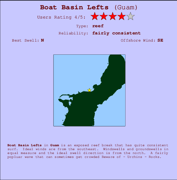
Boat Basin Lefts Surf Guide
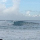
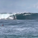
Boat Basin Lefts in Guam is an exposed reef break that has quite reliable surf. Offshore winds blow from the southeast. Waves just as likely from local windswells as from distant groundswells and the best swell direction is from the north. When the surf is up, it can get quite busy in the water. Take care of - Urchins - Rocks.
Boat Basin Lefts Spot Info
| Type: | Rating: | Reliability: | Todays Sea Temp*: |
|---|---|---|---|
| fairly consistent | 28.7°C*ocean temperature recorded from satellite |
Surfing Boat Basin Lefts:
The best conditions reported for surf at Boat Basin Lefts occur when a North swell combines with an offshore wind direction from the Southeast.
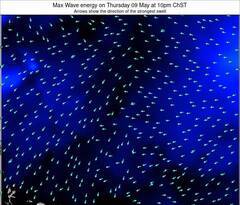
Voorspelde Golfenergie (Kracht): 12 uur


Boat Basin Lefts Surf:
Wednesday, 15 July 2026, 16:17 Local time| Wednesday 15 | ||||
| 1PM | 4PM | 7PM | 10PM | |
| Wave (m) | ||||
| Periode (s) | 10 | 10 | 10 | 10 |
| Wind (km/h) | ||||
| Wind | cross | cross | cross | cross |
- /breaks/Boat-Basin-Lefts/forecasts/latest
Boat Basin Lefts Surf Guide
Boat Basin Lefts in Guam is an exposed reef break that has quite reliable surf. Offshore winds blow from the southeast. Waves just as likely from local windswells as from distant groundswells and the best swell direction is from the north. When the surf is up, it can get quite busy in the water. Take care of - Urchins - Rocks.
Boat Basin Lefts Spot Info
Type: Rating: Reliability: Todays Sea Temp*:  Reef
Reef 4
4fairly consistent 28.7°C*ocean temperature recorded from satelliteSurfing Boat Basin Lefts:
The best conditions reported for surf at Boat Basin Lefts occur when a North swell combines with an offshore wind direction from the Southeast.
Voorspelde Golfenergie (Kracht): 12 uur
Gebruik de tabbladen hierboven om de zeewatertemperatuur bij Boat Basin Lefts te bekijken, foto's van Boat Basin Lefts, Boat Basin Lefts gedetailleerde golfvoorspellingen, wind- en weersvoorspellingen, Boat Basin Lefts webcams, actuele wind in Guam live weerstations en Boat Basin Lefts getijdenvoorspellingen. De link van Guam golfkaarten opent een grote afbeelding van Guam en de omliggende zeeën. Deze golfkaarten kunnen worden dynamisch gemaakt worden met de verschillende golfcomponenten, golfenergie, golfperiode, golfhoogte, samen met de wind en weersvoorspellingen, het actuele weer en de zeetoestand volgens golfboeien uit Guam, langskomende schepen en weerstations op de kust. Elk voorspelling pagina's voor dit surfstrand zijn voorzien van een wereldwijde en regionale golfzoeker om de beste surfsomstandigheden in het gebied rond Boat Basin Lefts te vinden.
Boat Basin Lefts Surf:
Wednesday, 15 July 2026, 16:17 Local timeWednesday 15 1PM 4PM 7PM 10PM Wave (m) Periode (s) 10 10 10 10 Wind (km/h) Wind cross cross cross cross - /breaks/Boat-Basin-Lefts/forecasts/latest
- /breaks/Boat-Basin-Lefts/forecasts/latest/six_day
Boat Basin Lefts Surf Guide
Boat Basin Lefts in Guam is an exposed reef break that has quite reliable surf. Offshore winds blow from the southeast. Waves just as likely from local windswells as from distant groundswells and the best swell direction is from the north. When the surf is up, it can get quite busy in the water. Take care of - Urchins - Rocks.
Boat Basin Lefts Spot Info
Type: Rating: Reliability: Todays Sea Temp*: Reef4fairly consistent 28.7°C*ocean temperature recorded from satelliteSurfing Boat Basin Lefts:
The best conditions reported for surf at Boat Basin Lefts occur when a North swell combines with an offshore wind direction from the Southeast.
Voorspelde Golfenergie (Kracht): 12 uur
Gebruik de tabbladen hierboven om de zeewatertemperatuur bij Boat Basin Lefts te bekijken, foto's van Boat Basin Lefts, Boat Basin Lefts gedetailleerde golfvoorspellingen, wind- en weersvoorspellingen, Boat Basin Lefts webcams, actuele wind in Guam live weerstations en Boat Basin Lefts getijdenvoorspellingen. De link van Guam golfkaarten opent een grote afbeelding van Guam en de omliggende zeeën. Deze golfkaarten kunnen worden dynamisch gemaakt worden met de verschillende golfcomponenten, golfenergie, golfperiode, golfhoogte, samen met de wind en weersvoorspellingen, het actuele weer en de zeetoestand volgens golfboeien uit Guam, langskomende schepen en weerstations op de kust. Elk voorspelling pagina's voor dit surfstrand zijn voorzien van een wereldwijde en regionale golfzoeker om de beste surfsomstandigheden in het gebied rond Boat Basin Lefts te vinden.
Boat Basin Lefts Surf:
Wednesday, 15 July 2026, 16:17 Local timeWednesday 15 1PM 4PM 7PM 10PM Wave (m) Periode (s) 10 10 10 10 Wind (km/h) Wind cross cross cross cross - /breaks/Boat-Basin-Lefts/forecasts/latest
Boat Basin Lefts Surf Guide
Boat Basin Lefts in Guam is an exposed reef break that has quite reliable surf. Offshore winds blow from the southeast. Waves just as likely from local windswells as from distant groundswells and the best swell direction is from the north. When the surf is up, it can get quite busy in the water. Take care of - Urchins - Rocks.
Boat Basin Lefts Spot Info
Type: Rating: Reliability: Todays Sea Temp*: Reef4fairly consistent 28.7°C*ocean temperature recorded from satelliteSurfing Boat Basin Lefts:
The best conditions reported for surf at Boat Basin Lefts occur when a North swell combines with an offshore wind direction from the Southeast.
Voorspelde Golfenergie (Kracht): 12 uur
Gebruik de tabbladen hierboven om de zeewatertemperatuur bij Boat Basin Lefts te bekijken, foto's van Boat Basin Lefts, Boat Basin Lefts gedetailleerde golfvoorspellingen, wind- en weersvoorspellingen, Boat Basin Lefts webcams, actuele wind in Guam live weerstations en Boat Basin Lefts getijdenvoorspellingen. De link van Guam golfkaarten opent een grote afbeelding van Guam en de omliggende zeeën. Deze golfkaarten kunnen worden dynamisch gemaakt worden met de verschillende golfcomponenten, golfenergie, golfperiode, golfhoogte, samen met de wind en weersvoorspellingen, het actuele weer en de zeetoestand volgens golfboeien uit Guam, langskomende schepen en weerstations op de kust. Elk voorspelling pagina's voor dit surfstrand zijn voorzien van een wereldwijde en regionale golfzoeker om de beste surfsomstandigheden in het gebied rond Boat Basin Lefts te vinden.
Boat Basin Lefts Surf:
Wednesday, 15 July 2026, 16:17 Local timeWednesday 15 1PM 4PM 7PM 10PM Wave (m) Periode (s) 10 10 10 10 Wind (km/h) Wind cross cross cross cross Tide Times:
Voor Tamuning, %{dist} %{km} van %{location}.
VOLGENDE IS OM (lokale tijd) resterende tijd hoog water laag water Boat Basin Lefts Tide Times and Tide Chart
Live Weather:
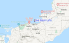
At Tamuning, 3 km from Boat Basin Lefts.
moderate winds from the WSW
(km/h)
dryAir temperature
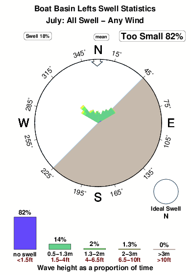
31°COverall Boat Basin Lefts Surf Consistency and Wind Distribution in July
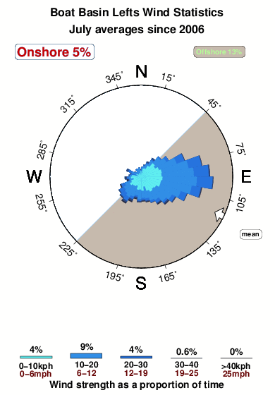


Wind stats for Boat Basin Lefts: see the variation in direction and stength by month.
surffoto's uit
de galerijContourlijnen: Wegen & Rivieren: Kies een surflokatie uit het menu 
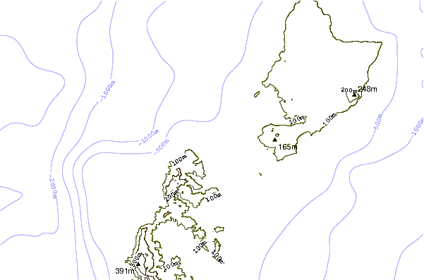
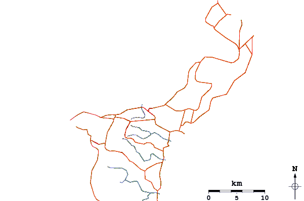
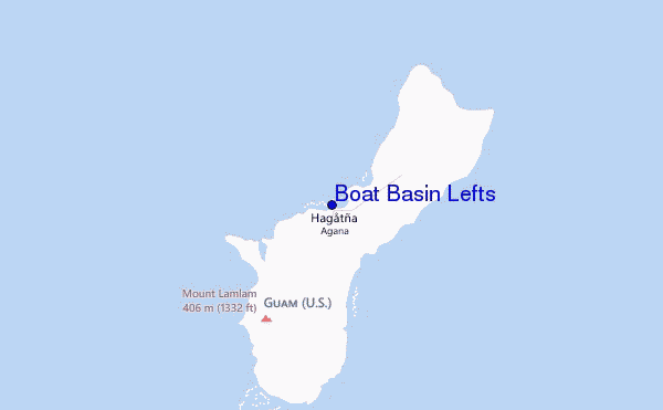
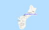
Gebruik deze reliëfkaart om naar de surfspots en de getijdenstations van Guam toe te gaan, in de buurt van Boat Basin Lefts.
Andere Dichtbijzijnde Surflocaties van Boat Basin Lefts:
(klik op locatienaam voor meer informatie)- Closest Locatie0 mi
- Second closest Locatie1 mi
- Third closest Locatie1 mi
- Fourth closest Locatie2 mi
- Fifth closest Locatie4 mi
Dichtstbijzijnde golfboeien bij Boat Basin Lefts:
- Closest golfboei9 mi
- Second closest golfboei14 mi
- Third closest golfboei138 mi
- Fourth closest golfboei745 mi
- Fifth closest golfboei1400 mi
Getijdenstations in de buurt van Boat Basin Lefts:
- Closest getijdenstationTamuning2 mi
- Second closest getijdenstationPago Bay5 mi
- Third closest getijdenstationDededo6 mi
- Fourth closest getijdenstationApra Harbor7 mi
- Fifth closest getijdenstationYigo10 mi
Airports
- The closest passenger airport to Boat Basin Lefts is Guam International (Agana) Airport (GUM) in Mariana Islands, 5 km (3 miles) away (directly).
- The second nearest airport to Boat Basin Lefts is Andersen Afb Airport (UAM), also in Mariana Islands, 22 km (14 miles) away.
- Third is Rota International Airport (ROP) in Mariana Islands, 93 km (58 miles) away.
- West Tinian Airport (TNI) in Mariana Islands is 193 km (120 miles) away.
- Saipan International Airport (SPN), also in Mariana Islands is the fifth nearest airport to Boat Basin Lefts and is 210 km (130 miles) away.
- /breaks/Boat-Basin-Lefts/forecasts/latest


 Nearest