
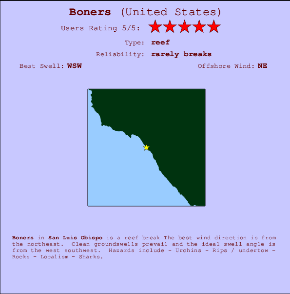
Boners Surf Guide
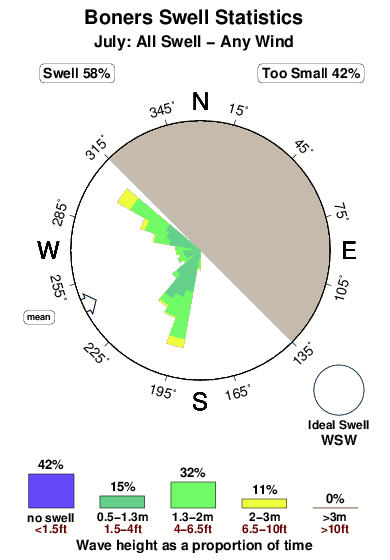
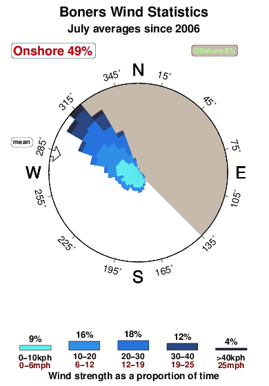
Boners in San Luis Obispo is an exposed reef break The best wind direction is from the northeast. Most of the surf here comes from groundswells and the best swell direction is from the west southwest. Watch out for - Urchins - Rips / undertow - Rocks - Localism - Sharks.
Boners Spot Info
| Type: | Rating: | Reliability: | Todays Sea Temp*: |
|---|---|---|---|
| rarely breaks | 14.6°C*ocean temperature recorded from satellite |
Surfing Boners:
The best conditions reported for surf at Boners occur when a West-southwest swell combines with an offshore wind direction from the Northeast.

Voorspelde Golfenergie (Kracht): 12 uur


Boners Surf:
Friday, 17 July 2026, 04:36 Local time| Friday 17 | ||||
| 2AM | 5AM | 8AM | 11AM | |
| Wave (m) | ||||
| Periode (s) | 8 | 8 | 8 | 8 |
| Wind (km/h) | ||||
| Wind | cross | glass | glass | cross- on |
- /breaks/Boners/forecasts/latest
Boners Surf Guide
Boners in San Luis Obispo is an exposed reef break The best wind direction is from the northeast. Most of the surf here comes from groundswells and the best swell direction is from the west southwest. Watch out for - Urchins - Rips / undertow - Rocks - Localism - Sharks.
Boners Spot Info
Type: Rating: Reliability: Todays Sea Temp*:  Reef
Reef 5
5rarely breaks 14.6°C*ocean temperature recorded from satelliteSurfing Boners:
The best conditions reported for surf at Boners occur when a West-southwest swell combines with an offshore wind direction from the Northeast.
Voorspelde Golfenergie (Kracht): 12 uur
Gebruik de tabbladen hierboven om de zeewatertemperatuur bij Boners te bekijken, foto's van Boners, Boners gedetailleerde golfvoorspellingen, wind- en weersvoorspellingen, Boners webcams, actuele wind in CAL - San Luis Obispo live weerstations en Boners getijdenvoorspellingen. De link van United States golfkaarten opent een grote afbeelding van United States en de omliggende zeeën. Deze golfkaarten kunnen worden dynamisch gemaakt worden met de verschillende golfcomponenten, golfenergie, golfperiode, golfhoogte, samen met de wind en weersvoorspellingen, het actuele weer en de zeetoestand volgens golfboeien uit United States, langskomende schepen en weerstations op de kust. Elk voorspelling pagina's voor dit surfstrand zijn voorzien van een wereldwijde en regionale golfzoeker om de beste surfsomstandigheden in het gebied rond Boners te vinden.
Boners Surf:
Friday, 17 July 2026, 04:36 Local timeFriday 17 2AM 5AM 8AM 11AM Wave (m) Periode (s) 8 8 8 8 Wind (km/h) Wind cross glass glass cross-
on- /breaks/Boners/forecasts/latest
- /breaks/Boners/forecasts/latest/six_day
Boners Surf Guide
Boners in San Luis Obispo is an exposed reef break The best wind direction is from the northeast. Most of the surf here comes from groundswells and the best swell direction is from the west southwest. Watch out for - Urchins - Rips / undertow - Rocks - Localism - Sharks.
Boners Spot Info
Type: Rating: Reliability: Todays Sea Temp*: Reef5rarely breaks 14.6°C*ocean temperature recorded from satelliteSurfing Boners:
The best conditions reported for surf at Boners occur when a West-southwest swell combines with an offshore wind direction from the Northeast.
Voorspelde Golfenergie (Kracht): 12 uur
Gebruik de tabbladen hierboven om de zeewatertemperatuur bij Boners te bekijken, foto's van Boners, Boners gedetailleerde golfvoorspellingen, wind- en weersvoorspellingen, Boners webcams, actuele wind in CAL - San Luis Obispo live weerstations en Boners getijdenvoorspellingen. De link van United States golfkaarten opent een grote afbeelding van United States en de omliggende zeeën. Deze golfkaarten kunnen worden dynamisch gemaakt worden met de verschillende golfcomponenten, golfenergie, golfperiode, golfhoogte, samen met de wind en weersvoorspellingen, het actuele weer en de zeetoestand volgens golfboeien uit United States, langskomende schepen en weerstations op de kust. Elk voorspelling pagina's voor dit surfstrand zijn voorzien van een wereldwijde en regionale golfzoeker om de beste surfsomstandigheden in het gebied rond Boners te vinden.
Boners Surf:
Friday, 17 July 2026, 04:36 Local timeFriday 17 2AM 5AM 8AM 11AM Wave (m) Periode (s) 8 8 8 8 Wind (km/h) Wind cross glass glass cross-
on- /breaks/Boners/forecasts/latest
Boners Surf Guide
Boners in San Luis Obispo is an exposed reef break The best wind direction is from the northeast. Most of the surf here comes from groundswells and the best swell direction is from the west southwest. Watch out for - Urchins - Rips / undertow - Rocks - Localism - Sharks.
Boners Spot Info
Type: Rating: Reliability: Todays Sea Temp*: Reef5rarely breaks 14.6°C*ocean temperature recorded from satelliteSurfing Boners:
The best conditions reported for surf at Boners occur when a West-southwest swell combines with an offshore wind direction from the Northeast.
Voorspelde Golfenergie (Kracht): 12 uur
Gebruik de tabbladen hierboven om de zeewatertemperatuur bij Boners te bekijken, foto's van Boners, Boners gedetailleerde golfvoorspellingen, wind- en weersvoorspellingen, Boners webcams, actuele wind in CAL - San Luis Obispo live weerstations en Boners getijdenvoorspellingen. De link van United States golfkaarten opent een grote afbeelding van United States en de omliggende zeeën. Deze golfkaarten kunnen worden dynamisch gemaakt worden met de verschillende golfcomponenten, golfenergie, golfperiode, golfhoogte, samen met de wind en weersvoorspellingen, het actuele weer en de zeetoestand volgens golfboeien uit United States, langskomende schepen en weerstations op de kust. Elk voorspelling pagina's voor dit surfstrand zijn voorzien van een wereldwijde en regionale golfzoeker om de beste surfsomstandigheden in het gebied rond Boners te vinden.
Boners Surf:
Friday, 17 July 2026, 04:36 Local timeFriday 17 2AM 5AM 8AM 11AM Wave (m) Periode (s) 8 8 8 8 Wind (km/h) Wind cross glass glass cross-
onTide Times:
Voor San Simeon, California, %{dist} %{km} van %{location}.
VOLGENDE IS OM (lokale tijd) resterende tijd hoog water laag water Boners Tide Times and Tide Chart
Live Weather:
At BUOY-MBXC1, 37 km from Boners.
- Air temperature
-°CBuoy Data:
At Diablo Canyon, CA, 32 miles from Boners.
11PM 12AM 1AM 2AM Gegevens Leeftijd 4 hr 3 hr 2 hr 1 hr Golfhoogte (m) 

Dominante Periode (s) 8 7 9 8 Overall Boners Surf Consistency and Wind Distribution in July
surffoto's uit
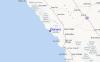
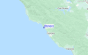
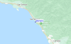
de galerijContourlijnen: Wegen & Rivieren: Kies een surflokatie uit het menu 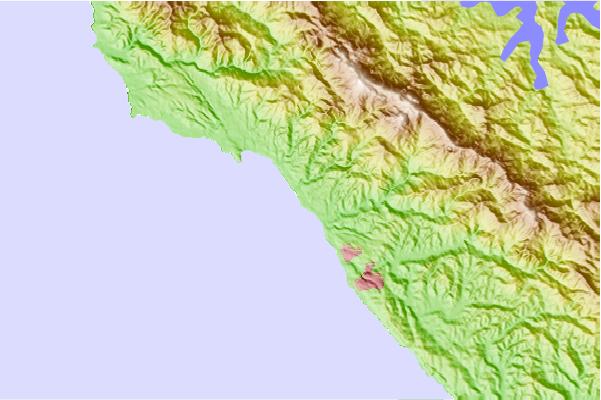
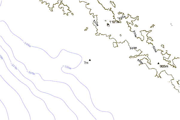
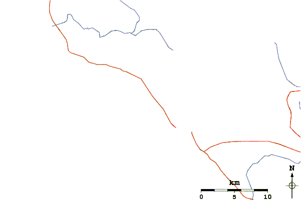
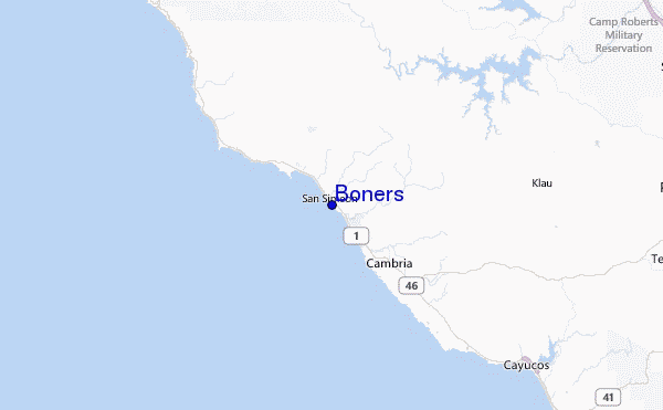
Gebruik deze reliëfkaart om naar de surfspots en de getijdenstations van CAL - San Luis Obispo toe te gaan, in de buurt van Boners.
Andere Dichtbijzijnde Surflocaties van Boners:
(klik op locatienaam voor meer informatie)- Closest Locatie0 mi
- Second closest Locatie1 mi
- Third closest Locatie2 mi
- Fourth closest Locatie3 mi
- Fifth closest Locatie3 mi
Dichtstbijzijnde golfboeien bij Boners:
- Closest golfboei32 mi
- Second closest golfboei42 mi
- Third closest golfboei53 mi
- Fourth closest golfboei63 mi
- Fifth closest golfboei67 mi
Getijdenstations in de buurt van Boners:
- Closest getijdenstationSan Simeon2 mi
- Second closest getijdenstationCambria5 mi
- Third closest getijdenstationMorro Beach, Estero Bay21 mi
- Fourth closest getijdenstationMorro Bay24 mi
- Fifth closest getijdenstationPort San Luis37 mi
Airports
- The closest passenger airport to Boners is Vandenberg Afb (Lompoc) Airport (VBG) in USA, 111 km (69 miles) away (directly).
- The second nearest airport to Boners is Lemoore Nas Airport (NLC), also in USA, 134 km (83 miles) away.
- Third is Fresno Yosemite International Airport (FAT) in USA, 182 km (113 miles) away.
- Meadows Fld (Bakersfield) Airport (BFL) in USA is 190 km (118 miles) away.
- Castle (Merced) Airport (MER), also in USA is the fifth nearest airport to Boners and is 204 km (127 miles) away.
- /breaks/Boners/forecasts/latest

 Nearest