
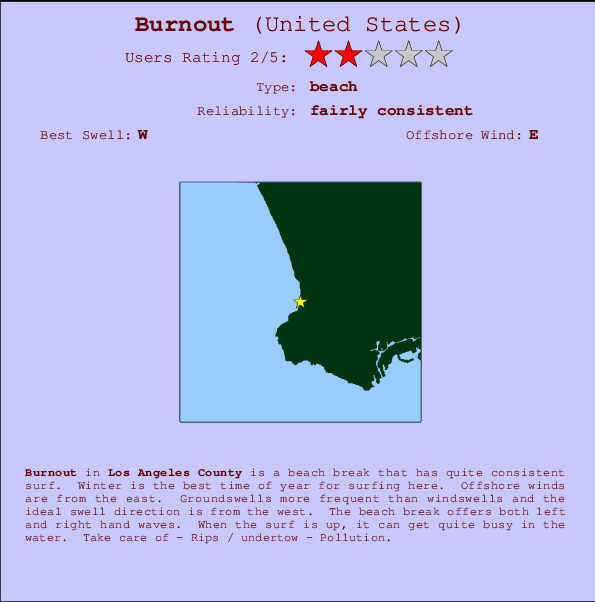
Burnout Surf Guide
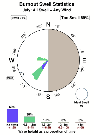
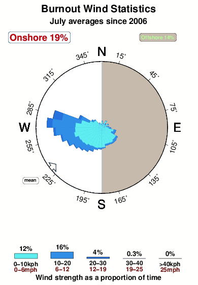
Burnout in Los Angeles County is an exposed beach break that has quite reliable surf. Winter is the best time of year for surfing here. Offshore winds are from the east. Groundswells are more common than windswells and the best swell direction is from the west. Waves at the beach break both left and right. Sometimes crowded. Hazards include - Rips / undertow - Pollution.
Burnout Spot Info
| Type: | Rating: | Reliability: | Todays Sea Temp*: |
|---|---|---|---|
| fairly consistent | 21.1°C*ocean temperature recorded from satellite |
Surfing Burnout:
The best conditions reported for surf at Burnout occur when a West swell combines with an offshore wind direction from the East.

Voorspelde Golfenergie (Kracht): 12 uur


Burnout Surf:
Thursday, 16 July 2026, 05:24 Local time| Thursday 16 | ||||
| 2AM | 5AM | 8AM | 11AM | |
| Wave (m) | ||||
| Periode (s) | 16 | 16 | 16 | 16 |
| Wind (km/h) | ||||
| Wind | cross- off |
cross- off |
cross- off |
cross- off |
- /breaks/Burnout/forecasts/latest
Burnout Surf Guide
Burnout in Los Angeles County is an exposed beach break that has quite reliable surf. Winter is the best time of year for surfing here. Offshore winds are from the east. Groundswells are more common than windswells and the best swell direction is from the west. Waves at the beach break both left and right. Sometimes crowded. Hazards include - Rips / undertow - Pollution.
Burnout Spot Info
Type: Rating: Reliability: Todays Sea Temp*:  Beach
Beach 2
2fairly consistent 21.1°C*ocean temperature recorded from satelliteSurfing Burnout:
The best conditions reported for surf at Burnout occur when a West swell combines with an offshore wind direction from the East.
Voorspelde Golfenergie (Kracht): 12 uur
Gebruik de tabbladen hierboven om de zeewatertemperatuur bij Burnout te bekijken, foto's van Burnout, Burnout gedetailleerde golfvoorspellingen, wind- en weersvoorspellingen, Burnout webcams, actuele wind in CAL - LA County live weerstations en Burnout getijdenvoorspellingen. De link van United States golfkaarten opent een grote afbeelding van United States en de omliggende zeeën. Deze golfkaarten kunnen worden dynamisch gemaakt worden met de verschillende golfcomponenten, golfenergie, golfperiode, golfhoogte, samen met de wind en weersvoorspellingen, het actuele weer en de zeetoestand volgens golfboeien uit United States, langskomende schepen en weerstations op de kust. Elk voorspelling pagina's voor dit surfstrand zijn voorzien van een wereldwijde en regionale golfzoeker om de beste surfsomstandigheden in het gebied rond Burnout te vinden.
Burnout Surf:
Thursday, 16 July 2026, 05:24 Local timeThursday 16 2AM 5AM 8AM 11AM Wave (m) Periode (s) 16 16 16 16 Wind (km/h) Wind cross-
offcross-
offcross-
offcross-
off- /breaks/Burnout/forecasts/latest
- /breaks/Burnout/forecasts/latest/six_day
Burnout Surf Guide
Burnout in Los Angeles County is an exposed beach break that has quite reliable surf. Winter is the best time of year for surfing here. Offshore winds are from the east. Groundswells are more common than windswells and the best swell direction is from the west. Waves at the beach break both left and right. Sometimes crowded. Hazards include - Rips / undertow - Pollution.
Burnout Spot Info
Type: Rating: Reliability: Todays Sea Temp*: Beach2fairly consistent 21.1°C*ocean temperature recorded from satelliteSurfing Burnout:
The best conditions reported for surf at Burnout occur when a West swell combines with an offshore wind direction from the East.
Voorspelde Golfenergie (Kracht): 12 uur
Gebruik de tabbladen hierboven om de zeewatertemperatuur bij Burnout te bekijken, foto's van Burnout, Burnout gedetailleerde golfvoorspellingen, wind- en weersvoorspellingen, Burnout webcams, actuele wind in CAL - LA County live weerstations en Burnout getijdenvoorspellingen. De link van United States golfkaarten opent een grote afbeelding van United States en de omliggende zeeën. Deze golfkaarten kunnen worden dynamisch gemaakt worden met de verschillende golfcomponenten, golfenergie, golfperiode, golfhoogte, samen met de wind en weersvoorspellingen, het actuele weer en de zeetoestand volgens golfboeien uit United States, langskomende schepen en weerstations op de kust. Elk voorspelling pagina's voor dit surfstrand zijn voorzien van een wereldwijde en regionale golfzoeker om de beste surfsomstandigheden in het gebied rond Burnout te vinden.
Burnout Surf:
Thursday, 16 July 2026, 05:24 Local timeThursday 16 2AM 5AM 8AM 11AM Wave (m) Periode (s) 16 16 16 16 Wind (km/h) Wind cross-
offcross-
offcross-
offcross-
off- /breaks/Burnout/forecasts/latest
Burnout Surf Guide
Burnout in Los Angeles County is an exposed beach break that has quite reliable surf. Winter is the best time of year for surfing here. Offshore winds are from the east. Groundswells are more common than windswells and the best swell direction is from the west. Waves at the beach break both left and right. Sometimes crowded. Hazards include - Rips / undertow - Pollution.
Burnout Spot Info
Type: Rating: Reliability: Todays Sea Temp*: Beach2fairly consistent 21.1°C*ocean temperature recorded from satelliteSurfing Burnout:
The best conditions reported for surf at Burnout occur when a West swell combines with an offshore wind direction from the East.
Voorspelde Golfenergie (Kracht): 12 uur
Gebruik de tabbladen hierboven om de zeewatertemperatuur bij Burnout te bekijken, foto's van Burnout, Burnout gedetailleerde golfvoorspellingen, wind- en weersvoorspellingen, Burnout webcams, actuele wind in CAL - LA County live weerstations en Burnout getijdenvoorspellingen. De link van United States golfkaarten opent een grote afbeelding van United States en de omliggende zeeën. Deze golfkaarten kunnen worden dynamisch gemaakt worden met de verschillende golfcomponenten, golfenergie, golfperiode, golfhoogte, samen met de wind en weersvoorspellingen, het actuele weer en de zeetoestand volgens golfboeien uit United States, langskomende schepen en weerstations op de kust. Elk voorspelling pagina's voor dit surfstrand zijn voorzien van een wereldwijde en regionale golfzoeker om de beste surfsomstandigheden in het gebied rond Burnout te vinden.
Burnout Surf:
Thursday, 16 July 2026, 05:24 Local timeThursday 16 2AM 5AM 8AM 11AM Wave (m) Periode (s) 16 16 16 16 Wind (km/h) Wind cross-
offcross-
offcross-
offcross-
offTide Times:
Voor Palos Verdes Estates, %{dist} %{km} van %{location}.
VOLGENDE IS OM (lokale tijd) resterende tijd hoog water laag water Burnout Tide Times and Tide Chart
Live Weather:
At Torrance Municipal Airport, 8 km from Burnout.
light winds from the SE
(km/h)
Dry and partly cloudyAir temperature
20.4°CBuoy Data:
At Long Beach Channel, CA, 14 miles from Burnout.
12AM 1AM 2AM 3AM Gegevens Leeftijd 4 hr 3 hr 2 hr 1 hr Golfhoogte (m) 


Dominante Periode (s) 13 17 13 13 Overall Burnout Surf Consistency and Wind Distribution in July
surffoto's uit
de galerijContourlijnen: Wegen & Rivieren: Kies een surflokatie uit het menu 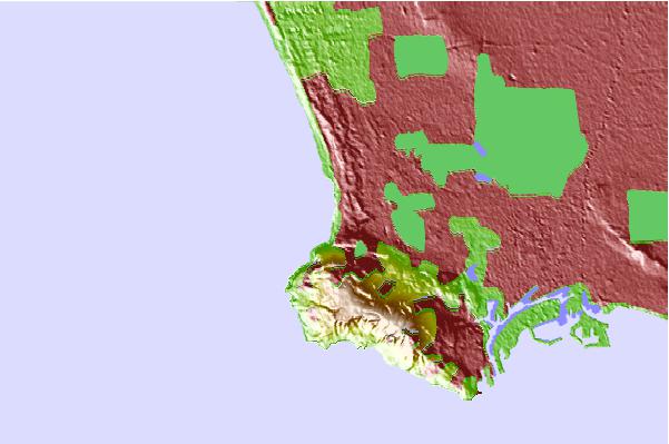
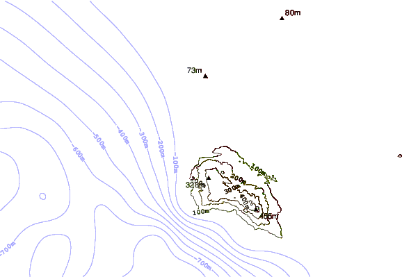
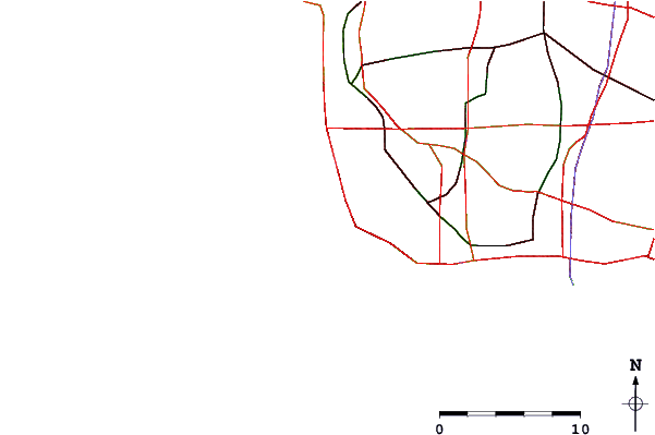
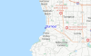
Gebruik deze reliëfkaart om naar de surfspots en de getijdenstations van CAL - LA County toe te gaan, in de buurt van Burnout.
Andere Dichtbijzijnde Surflocaties van Burnout:
(klik op locatienaam voor meer informatie)- Closest Locatie1 mi
- Second closest Locatie1 mi
- Third closest Locatie1 mi
- Fourth closest Locatie1 mi
- Fifth closest Locatie1 mi
Dichtstbijzijnde golfboeien bij Burnout:
- Closest golfboei14 mi
- Second closest golfboei14 mi
- Third closest golfboei14 mi
- Fourth closest golfboei21 mi
- Fifth closest golfboei36 mi
Getijdenstations in de buurt van Burnout:
- Closest getijdenstationPalos Verdes Estates1 mi
- Second closest getijdenstationKing Harbor, Santa Monica Bay2 mi
- Third closest getijdenstationLomita5 mi
- Fourth closest getijdenstationManhattan Beach5 mi
- Fifth closest getijdenstationRancho Palos Verdes5 mi
Airports
- The closest passenger airport to Burnout is Jack Northrop Fld Hawthorne Muni Airport (HHR) in USA, 13 km (8 miles) away (directly).
- The second nearest airport to Burnout is Los Angeles International Airport (LAX), also in USA, 14 km (9 miles) away.
- Third is Long Beach Airport (LGB) in USA, 22 km (14 miles) away.
- Burbank Glendale Pasadena Airport (BUR) in USA is 43 km (27 miles) away.
- John Wayne Arpt Orange Co (Santa Ana) Airport (SNA), also in USA is the fifth nearest airport to Burnout and is 51 km (32 miles) away.
- /breaks/Burnout/forecasts/latest


 Nearest