
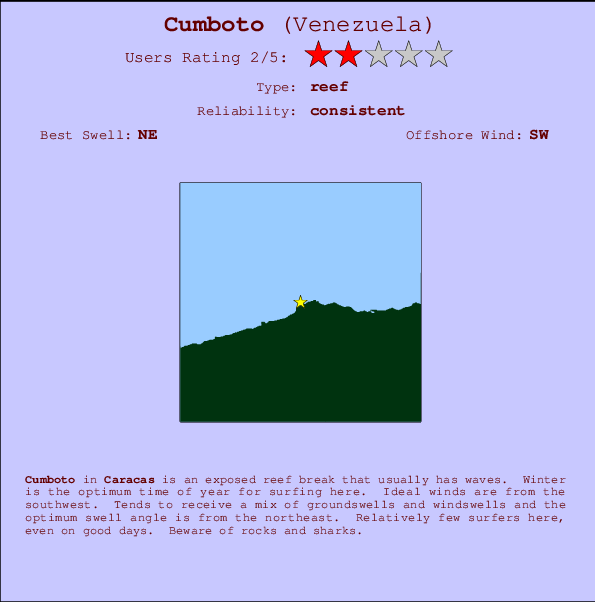
Cumboto Surf Guide
Cumboto in Caracas Area is an exposed reef break that has consistent surf. Winter is the best time of year for surfing here. The best wind direction is from the southwest. Tends to receive a mix of groundswells and windswells and the best swell direction is from the northeast. There is a left breaking reef. Even when there are waves, it's not likley to be crowded. Watch out for rocks and sharks.
Cumboto Spot Info
| Type: | Rating: | Reliability: | Todays Sea Temp*: |
|---|---|---|---|
| consistent | 27.0°C*ocean temperature recorded from satellite |
Surfing Cumboto:
The best conditions reported for surf at Cumboto occur when a Northeast swell combines with an offshore wind direction from the Southwest.
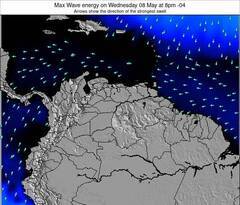
Voorspelde Golfenergie (Kracht): 12 uur

Cumboto Surf:
Tuesday, 21 July 2026, 09:58 Local time| Tuesday 21 | ||||
| 11AM | 2PM | 5PM | 8PM | |
| Wave (m) | ||||
| Periode (s) | 6 | 6 | 6 | 7 |
| Wind (km/h) | ||||
| Wind | on | cross- on |
cross- on |
cross- on |
- /breaks/Cumboto/forecasts/latest
Cumboto Surf Guide
Cumboto in Caracas Area is an exposed reef break that has consistent surf. Winter is the best time of year for surfing here. The best wind direction is from the southwest. Tends to receive a mix of groundswells and windswells and the best swell direction is from the northeast. There is a left breaking reef. Even when there are waves, it's not likley to be crowded. Watch out for rocks and sharks.
Cumboto Spot Info
Type: Rating: Reliability: Todays Sea Temp*:  Reef
Reef 2
2consistent 27.0°C*ocean temperature recorded from satelliteSurfing Cumboto:
The best conditions reported for surf at Cumboto occur when a Northeast swell combines with an offshore wind direction from the Southwest.
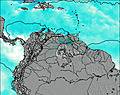
Voorspelde Golfenergie (Kracht): 12 uur
Gebruik de tabbladen hierboven om de zeewatertemperatuur bij Cumboto te bekijken, foto's van Cumboto, Cumboto gedetailleerde golfvoorspellingen, wind- en weersvoorspellingen, Cumboto webcams, actuele wind in Caracas live weerstations en Cumboto getijdenvoorspellingen. De link van Venezuela golfkaarten opent een grote afbeelding van Venezuela en de omliggende zeeën. Deze golfkaarten kunnen worden dynamisch gemaakt worden met de verschillende golfcomponenten, golfenergie, golfperiode, golfhoogte, samen met de wind en weersvoorspellingen, het actuele weer en de zeetoestand volgens golfboeien uit Venezuela, langskomende schepen en weerstations op de kust. Elk voorspelling pagina's voor dit surfstrand zijn voorzien van een wereldwijde en regionale golfzoeker om de beste surfsomstandigheden in het gebied rond Cumboto te vinden.
Cumboto Surf:
Tuesday, 21 July 2026, 09:58 Local timeTuesday 21 11AM 2PM 5PM 8PM Wave (m) Periode (s) 6 6 6 7 Wind (km/h) Wind on cross-
oncross-
oncross-
on- /breaks/Cumboto/forecasts/latest
- /breaks/Cumboto/forecasts/latest/six_day
Cumboto Surf Guide
Cumboto in Caracas Area is an exposed reef break that has consistent surf. Winter is the best time of year for surfing here. The best wind direction is from the southwest. Tends to receive a mix of groundswells and windswells and the best swell direction is from the northeast. There is a left breaking reef. Even when there are waves, it's not likley to be crowded. Watch out for rocks and sharks.
Cumboto Spot Info
Type: Rating: Reliability: Todays Sea Temp*: Reef2consistent 27.0°C*ocean temperature recorded from satelliteSurfing Cumboto:
The best conditions reported for surf at Cumboto occur when a Northeast swell combines with an offshore wind direction from the Southwest.
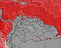
Voorspelde Golfenergie (Kracht): 12 uur
Gebruik de tabbladen hierboven om de zeewatertemperatuur bij Cumboto te bekijken, foto's van Cumboto, Cumboto gedetailleerde golfvoorspellingen, wind- en weersvoorspellingen, Cumboto webcams, actuele wind in Caracas live weerstations en Cumboto getijdenvoorspellingen. De link van Venezuela golfkaarten opent een grote afbeelding van Venezuela en de omliggende zeeën. Deze golfkaarten kunnen worden dynamisch gemaakt worden met de verschillende golfcomponenten, golfenergie, golfperiode, golfhoogte, samen met de wind en weersvoorspellingen, het actuele weer en de zeetoestand volgens golfboeien uit Venezuela, langskomende schepen en weerstations op de kust. Elk voorspelling pagina's voor dit surfstrand zijn voorzien van een wereldwijde en regionale golfzoeker om de beste surfsomstandigheden in het gebied rond Cumboto te vinden.
Cumboto Surf:
Tuesday, 21 July 2026, 09:58 Local timeTuesday 21 11AM 2PM 5PM 8PM Wave (m) Periode (s) 6 6 6 7 Wind (km/h) Wind on cross-
oncross-
oncross-
on- /breaks/Cumboto/forecasts/latest
Cumboto Surf Guide
Cumboto in Caracas Area is an exposed reef break that has consistent surf. Winter is the best time of year for surfing here. The best wind direction is from the southwest. Tends to receive a mix of groundswells and windswells and the best swell direction is from the northeast. There is a left breaking reef. Even when there are waves, it's not likley to be crowded. Watch out for rocks and sharks.
Cumboto Spot Info
Type: Rating: Reliability: Todays Sea Temp*: Reef2consistent 27.0°C*ocean temperature recorded from satelliteSurfing Cumboto:
The best conditions reported for surf at Cumboto occur when a Northeast swell combines with an offshore wind direction from the Southwest.
Voorspelde Golfenergie (Kracht): 12 uur
Gebruik de tabbladen hierboven om de zeewatertemperatuur bij Cumboto te bekijken, foto's van Cumboto, Cumboto gedetailleerde golfvoorspellingen, wind- en weersvoorspellingen, Cumboto webcams, actuele wind in Caracas live weerstations en Cumboto getijdenvoorspellingen. De link van Venezuela golfkaarten opent een grote afbeelding van Venezuela en de omliggende zeeën. Deze golfkaarten kunnen worden dynamisch gemaakt worden met de verschillende golfcomponenten, golfenergie, golfperiode, golfhoogte, samen met de wind en weersvoorspellingen, het actuele weer en de zeetoestand volgens golfboeien uit Venezuela, langskomende schepen en weerstations op de kust. Elk voorspelling pagina's voor dit surfstrand zijn voorzien van een wereldwijde en regionale golfzoeker om de beste surfsomstandigheden in het gebied rond Cumboto te vinden.
Cumboto Surf:
Tuesday, 21 July 2026, 09:58 Local timeTuesday 21 11AM 2PM 5PM 8PM Wave (m) Periode (s) 6 6 6 7 Wind (km/h) Wind on cross-
oncross-
oncross-
onTide Times:
Voor Catia La Mar, %{dist} %{km} van %{location}.
VOLGENDE IS OM (lokale tijd) resterende tijd hoog water laag water Cumboto Tide Times and Tide Chart
Live Weather:
At Caracas Airport/Aeropuerto Internacional Simon Bolivar, 8 km from Cumboto.
calm
(km/h)Air temperature
-°COverall Cumboto Surf Consistency and Wind Distribution in July
surffoto's uit
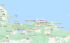
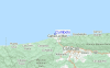
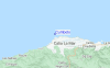
de galerijContourlijnen: Wegen & Rivieren: Kies een surflokatie uit het menu 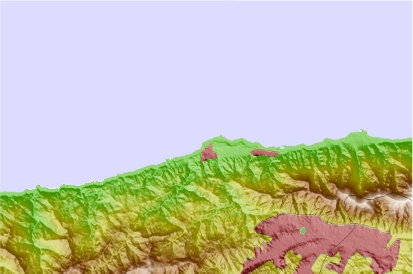
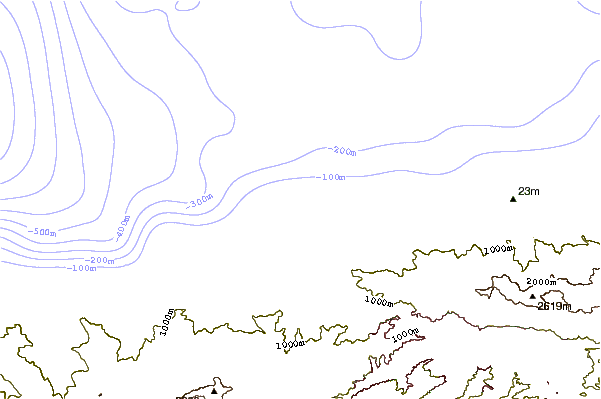
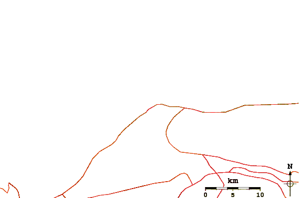
Gebruik deze reliëfkaart om naar de surfspots en de getijdenstations van Caracas toe te gaan, in de buurt van Cumboto.
Andere Dichtbijzijnde Surflocaties van Cumboto:
(klik op locatienaam voor meer informatie)- Closest Locatie2 mi
- Second closest Locatie3 mi
- Third closest Locatie4 mi
- Fourth closest Locatie4 mi
- Fifth closest Locatie12 mi
Dichtstbijzijnde golfboeien bij Cumboto:
- Closest golfboei471 mi
- Second closest golfboei502 mi
- Third closest golfboei537 mi
- Fourth closest golfboei539 mi
- Fifth closest golfboei546 mi
Getijdenstations in de buurt van Cumboto:
- Closest getijdenstationCatia La Mar4 mi
- Second closest getijdenstationMaiquetia6 mi
- Third closest getijdenstationCaracas9 mi
- Fourth closest getijdenstationLa Guaira10 mi
- Fifth closest getijdenstationPuerto Cabello78 mi
Airports
- The closest passenger airport to Cumboto is Simon Bolivar International (Caracas) Airport (CCS) in Venezuela, 5 km (3 miles) away (directly).
- The second nearest airport to Cumboto is Arturo Michelena International (Valencia) Airport (VLN), also in Venezuela, 110 km (68 miles) away.
- Third is General Bartolome Salom International (Puerto Cabello) Airport (PBL) in Venezuela, 115 km (71 miles) away.
- Sub Teniente Nestor Arias (San Felipe) Airport (SFH) in Venezuela is 192 km (119 miles) away.
- Valle De La Pascua Airport (VDP), also in Venezuela is the fifth nearest airport to Cumboto and is 192 km (119 miles) away.
- /breaks/Cumboto/forecasts/latest


 Nearest