
Golfvoorspellingen:

Voorspelling Lange TermijnZware regen (totaal 36mm), zwaarst tijdens maandagmiddag. Warm (max 29°C op zaterdagmiddag, min 28°C op vrijdagavond). Wind zal licht zijn over het algemeen. | |||||||||||||||||||
Fri 24 | Saturday 25 | Sunday 26 | |||||||||||||||||
5 PM | 8 PM | 11 PM | 2 AM | 5 AM | 8 AM | 11 AM | 2 PM | 5 PM | 8 PM | 11 PM | 2 AM | 5 AM | 8 AM | 11 AM | 2 PM | 5 PM | 8 PM | 11 PM | |
Golfhoogte kaart | 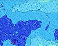 | 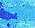 | 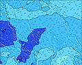 | 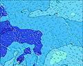 |  |  |  | ||||||||||||
Golf Hoogte (m) Richting Periode (s) | SSW 17 | SSW 16 | SSW 16 | SSW 16 | SSW 16 | SSW 16 | SSW 15 | SSW 15 | SSW 15 | SSW 14 | SSW 14 | SSW 14 | SSW 14 | SSW 14 | SSW 14 | SSW 14 | SSW 14 | SSW 14 | SSW 14 |
Golf Grafiek | |||||||||||||||||||
1351 | 1091 | 1064 | 917 | 906 | 883 | 734 | 696 | 648 | 536 | 529 | 529 | 431 | 419 | 395 | 390 | 407 | 419 | 395 | |
Wind (km/h) | |||||||||||||||||||
Wind onshore cross-onshore cross-shore cross-offshore offshore glasachtig | cross-off | cross-off | cross-off | cross-off | cross-off | cross-off | cross-off | cross-off | cross-off | off | cross-off | cross-off | cross-off | cross-off | cross-off | cross-off | cross-off | cross-off | off |
Vloed | 5:00PM0.78m | 4:29AM0.31m | 5:34PM0.80m | 5:10AM0.33m | 6:07PM0.82m | ||||||||||||||
Eb | 00:44AM0.25m | 9:47AM0.15m | 1:06AM0.23m | 10:30AM0.13m | |||||||||||||||
— | — | — | — | 6:35 | — | — | — | — | — | — | — | 6:35 | — | — | — | — | — | — | |
6:52 | — | — | — | — | — | — | — | 6:52 | — | — | — | — | — | — | — | 6:52 | — | — | |
mm | 2 | — | 2 | — | — | — | — | — | — | 1 | 2 | 3 | 1 | 1 | 3 | 3 | 3 | 3 | 3 |
Temp. °C | 28 | 28 | 28 | 28 | 28 | 28 | 28 | 28 | 29 | 28 | 28 | 28 | 28 | 28 | 28 | 28 | 28 | 28 | 28 |
Chill °C | 31 | 31 | 31 | 30 | 30 | 30 | 30 | 30 | 32 | 30 | 30 | 30 | 30 | 30 | 30 | 30 | 30 | 31 | 31 |
Swell 1 Hoogte (m) Richting Periode (s) | SSW 17 | SSW 16 | SSW 16 | SSW 16 | SSW 16 | SSW 16 | SSW 15 | SSW 15 | SSW 15 | SSW 14 | SSW 14 | SSW 14 | SSW 14 | SSW 14 | SSW 14 | SSW 14 | SSW 14 | SSW 14 | SSW 14 |
1351 | 1091 | 1064 | 917 | 906 | 883 | 734 | 696 | 648 | 536 | 529 | 529 | 431 | 419 | 395 | 390 | 407 | 419 | 395 | |
Swell 2 Hoogte (m) Richting Periode (s) | NE 8 | NE 8 | NE 8 | NE 8 | NE 10 | NE 10 | NE 10 | NE 10 | NE 10 | NE 10 | NE 10 | NE 10 | ESE 9 | NE 9 | NE 9 | NNE 8 | NNE 8 | ESE 8 | ESE 8 |
102 | 97 | 93 | 86 | 153 | 122 | 117 | 115 | 115 | 115 | 136 | 130 | 68 | 41 | 51 | 52 | 52 | 105 | 96 | |
Swell 3 Hoogte (m) Richting Periode (s) | SSE 10 | SSE 10 | SSE 10 | S 9 | S 9 | SSE 9 | SSE 9 | SSE 9 | ESE 8 | ESE 8 | ESE 8 | ESE 8 | NE 9 | N 8 | N 8 | ENE 16 | ENE 16 | NNE 8 | NNE 8 |
74 | 77 | 54 | 41 | 40 | 49 | 47 | 47 | 40 | 40 | 57 | 62 | 43 | 33 | 33 | 103 | 105 | 50 | 50 | |
Windgolven Hoogte (m) Richting Periode (s) | — | — | — | — | — | — | — | — | — | — | — | — | ENE 6 | ESE 9 | ESE 9 | ESE 9 | ESE 9 | — | — |
— | — | — | — | — | — | — | — | — | — | — | — | 15 | 121 | 121 | 111 | 106 | — | — | |
Dichtstbijzijnd Glasachtig of Offshore | |||||||||||||||||||
Afstand (km) | 0 | 0 | 0 | 1726 | 1726 | 1777 | 1809 | 1891 | 0 | 0 | 1776 | 1776 | 1776 | 1787 | 1828 | 1828 | 1828 | 0 | 0 |
Beste voorspelde golfomstandigheden in Line Islands | |||||||||||||||||||
Beste voorspelde golfomstandigheden in Kiribati | |||||||||||||||||||
Wereldwijde Golfzoeker | |||||||||||||||||||
- Map Icons:
 Break
Break Live Wave Height (m)
 Live Wind Speed (km/h)
 Surf Rating (10 Max)
 Ocean Swells (m)
- Wind Speed (km/h)
GRATIS Surf-Forecast.com widget voor je website
Het gratis surfbericht/weer widget hieronder is beschikbaar voor websites en geeft een samenvatting van de golfvoorspelling voor English Channel Left (Fanning Island). Kopieer de HTML-code en plak deze in je eigen site. Je kunt je eigen voorkeurstaal en eenheden kiezen zodat de voorspelling afgesteld is op de gebruikers van jouw site. Klik hier voor de code.
Gedetailleerde Golfvoorspelling voor English Channel Left (Fanning Island) zien bij:
surf-forecast.com
surf-forecast.com
 Nearest