
Fly Roads Surf Guide
Fly Roads in Newcastle is an exposed beach break that has very consistent surf. Autumn and winter are the best times of year for waves. The best wind direction is from the southwest. Tends to receive a mix of groundswells and windswells and the optimum swell angle is from the south. The beach breaks are all lefts. Good surf at all stages of the tide. A fairly popluar wave that can sometimes get crowded Be wary of sharks, they are not unknown here.
Fly Roads Spot Info
| Type: | Rating: | Reliability: | Todays Sea Temp*: |
|---|---|---|---|
| very consistent | 19.3°C*ocean temperature recorded from satellite |
Surfing Fly Roads:
The best conditions reported for surf at Fly Roads occur when a South swell combines with an offshore wind direction from the North-northeast.
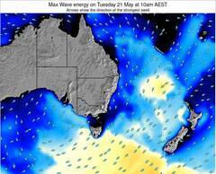
Voorspelde Golfenergie (Kracht): 12 uur

Fly Roads Surf:
Wednesday, 15 July 2026, 19:19 Local time| Wed | Thu | |||
| 7PM | 10PM | 1AM | 4AM | |
| Wave (m) | ||||
| Periode (s) | 9 | 9 | 8 | 8 |
| Wind (km/h) | ||||
| Wind | on | cross- on |
cross- on |
on |
- /breaks/Fly-Roads/forecasts/latest
Fly Roads Surf Guide
Fly Roads in Newcastle is an exposed beach break that has very consistent surf. Autumn and winter are the best times of year for waves. The best wind direction is from the southwest. Tends to receive a mix of groundswells and windswells and the optimum swell angle is from the south. The beach breaks are all lefts. Good surf at all stages of the tide. A fairly popluar wave that can sometimes get crowded Be wary of sharks, they are not unknown here.
Fly Roads Spot Info
Type: Rating: Reliability: Todays Sea Temp*:  Beach
Beach 2
2very consistent 19.3°C*ocean temperature recorded from satelliteSurfing Fly Roads:
The best conditions reported for surf at Fly Roads occur when a South swell combines with an offshore wind direction from the North-northeast.
Voorspelde Golfenergie (Kracht): 12 uur
Gebruik de tabbladen hierboven om de zeewatertemperatuur bij Fly Roads te bekijken, foto's van Fly Roads, Fly Roads gedetailleerde golfvoorspellingen, wind- en weersvoorspellingen, Fly Roads webcams, actuele wind in NSW - Newcastle live weerstations en Fly Roads getijdenvoorspellingen. De link van Australia golfkaarten opent een grote afbeelding van Australia en de omliggende zeeën. Deze golfkaarten kunnen worden dynamisch gemaakt worden met de verschillende golfcomponenten, golfenergie, golfperiode, golfhoogte, samen met de wind en weersvoorspellingen, het actuele weer en de zeetoestand volgens golfboeien uit Australia, langskomende schepen en weerstations op de kust. Elk voorspelling pagina's voor dit surfstrand zijn voorzien van een wereldwijde en regionale golfzoeker om de beste surfsomstandigheden in het gebied rond Fly Roads te vinden.
Fly Roads Surf:
Wednesday, 15 July 2026, 19:19 Local timeWed Thu 7PM 10PM 1AM 4AM Wave (m) Periode (s) 9 9 8 8 Wind (km/h) Wind on cross-
oncross-
onon - /breaks/Fly-Roads/forecasts/latest
- /breaks/Fly-Roads/forecasts/latest/six_day
Fly Roads Surf Guide
Fly Roads in Newcastle is an exposed beach break that has very consistent surf. Autumn and winter are the best times of year for waves. The best wind direction is from the southwest. Tends to receive a mix of groundswells and windswells and the optimum swell angle is from the south. The beach breaks are all lefts. Good surf at all stages of the tide. A fairly popluar wave that can sometimes get crowded Be wary of sharks, they are not unknown here.
Fly Roads Spot Info
Type: Rating: Reliability: Todays Sea Temp*: Beach2very consistent 19.3°C*ocean temperature recorded from satelliteSurfing Fly Roads:
The best conditions reported for surf at Fly Roads occur when a South swell combines with an offshore wind direction from the North-northeast.
Voorspelde Golfenergie (Kracht): 12 uur
Gebruik de tabbladen hierboven om de zeewatertemperatuur bij Fly Roads te bekijken, foto's van Fly Roads, Fly Roads gedetailleerde golfvoorspellingen, wind- en weersvoorspellingen, Fly Roads webcams, actuele wind in NSW - Newcastle live weerstations en Fly Roads getijdenvoorspellingen. De link van Australia golfkaarten opent een grote afbeelding van Australia en de omliggende zeeën. Deze golfkaarten kunnen worden dynamisch gemaakt worden met de verschillende golfcomponenten, golfenergie, golfperiode, golfhoogte, samen met de wind en weersvoorspellingen, het actuele weer en de zeetoestand volgens golfboeien uit Australia, langskomende schepen en weerstations op de kust. Elk voorspelling pagina's voor dit surfstrand zijn voorzien van een wereldwijde en regionale golfzoeker om de beste surfsomstandigheden in het gebied rond Fly Roads te vinden.
Fly Roads Surf:
Wednesday, 15 July 2026, 19:19 Local timeWed Thu 7PM 10PM 1AM 4AM Wave (m) Periode (s) 9 9 8 8 Wind (km/h) Wind on cross-
oncross-
onon - /breaks/Fly-Roads/forecasts/latest
Fly Roads Surf Guide
Fly Roads in Newcastle is an exposed beach break that has very consistent surf. Autumn and winter are the best times of year for waves. The best wind direction is from the southwest. Tends to receive a mix of groundswells and windswells and the optimum swell angle is from the south. The beach breaks are all lefts. Good surf at all stages of the tide. A fairly popluar wave that can sometimes get crowded Be wary of sharks, they are not unknown here.
Fly Roads Spot Info
Type: Rating: Reliability: Todays Sea Temp*: Beach2very consistent 19.3°C*ocean temperature recorded from satelliteSurfing Fly Roads:
The best conditions reported for surf at Fly Roads occur when a South swell combines with an offshore wind direction from the North-northeast.
Voorspelde Golfenergie (Kracht): 12 uur
Gebruik de tabbladen hierboven om de zeewatertemperatuur bij Fly Roads te bekijken, foto's van Fly Roads, Fly Roads gedetailleerde golfvoorspellingen, wind- en weersvoorspellingen, Fly Roads webcams, actuele wind in NSW - Newcastle live weerstations en Fly Roads getijdenvoorspellingen. De link van Australia golfkaarten opent een grote afbeelding van Australia en de omliggende zeeën. Deze golfkaarten kunnen worden dynamisch gemaakt worden met de verschillende golfcomponenten, golfenergie, golfperiode, golfhoogte, samen met de wind en weersvoorspellingen, het actuele weer en de zeetoestand volgens golfboeien uit Australia, langskomende schepen en weerstations op de kust. Elk voorspelling pagina's voor dit surfstrand zijn voorzien van een wereldwijde en regionale golfzoeker om de beste surfsomstandigheden in het gebied rond Fly Roads te vinden.
Fly Roads Surf:
Wednesday, 15 July 2026, 19:19 Local timeWed Thu 7PM 10PM 1AM 4AM Wave (m) Periode (s) 9 9 8 8 Wind (km/h) Wind on cross-
oncross-
onon Tide Times:
Voor Port Stephens, Australia, %{dist} %{km} van %{location}.
VOLGENDE IS OM (lokale tijd) resterende tijd hoog water laag water Fly Roads Tide Times and Tide Chart
Live Weather:
At Shoal Bay wx, 5 km from Fly Roads.
light winds from the SSW
(km/h)
dryAir temperature
13°COverall Fly Roads Surf Consistency and Wind Distribution in July
surffoto's uit
de galerijContourlijnen: Wegen & Rivieren: Kies een surflokatie uit het menu 


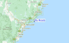
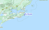
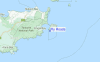
Gebruik deze reliëfkaart om naar de surfspots en de getijdenstations van NSW - Newcastle toe te gaan, in de buurt van Fly Roads.
Andere Dichtbijzijnde Surflocaties van Fly Roads:
(klik op locatienaam voor meer informatie)- Closest Locatie1 mi
- Second closest Locatie1 mi
- Third closest Locatie2 mi
- Fourth closest Locatie4 mi
- Fifth closest Locatie7 mi
Dichtstbijzijnde golfboeien bij Fly Roads:
- Closest golfboei76 mi
- Second closest golfboei84 mi
- Third closest golfboei137 mi
- Fourth closest golfboei177 mi
- Fifth closest golfboei229 mi
Getijdenstations in de buurt van Fly Roads:
- Closest getijdenstationPort Stephens2 mi
- Second closest getijdenstationCorlette5 mi
- Third closest getijdenstationBroughton Island12 mi
- Fourth closest getijdenstationNewcastle27 mi
- Fifth closest getijdenstationCharlestown34 mi
Airports
- The closest passenger airport to Fly Roads is Newcastle Airport (NTL) in Australia, 33 km (20 miles) away (directly).
- The second nearest airport to Fly Roads is Richmond Airport (RCM), also in Australia, 161 km (100 miles) away.
- Third is Kingsford Smith International Airport (Sydney) Airport (SYD) in Australia, 163 km (101 miles) away.
- Sydney Bankstown Airport (BWU) in Australia is 172 km (107 miles) away.
- Camden Airport (CDU), also in Australia is the fifth nearest airport to Fly Roads and is 200 km (124 miles) away.

- /breaks/Fly-Roads/forecasts/latest


 Nearest