
4 Mile Surf Guide
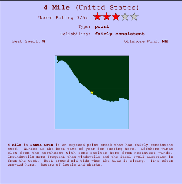
4 Mile in Santa Cruz is an exposed point break that has quite reliable surf. Winter is the best time of year for surfing here. Ideal winds are from the northeast. Groundswells more frequent than windswells and the best swell direction is from the west. Best around mid tide when the tide is rising. It's often crowded here. Beware of locals and sharks.
4 Mile Spot Info
| Type: | Rating: | Reliability: | Todays Sea Temp*: |
|---|---|---|---|
| fairly consistent | 15.5°C*ocean temperature recorded from satellite |
Surfing 4 Mile:
The best conditions reported for surf at 4 Mile occur when a West swell combines with an offshore wind direction from the Northeast.

Voorspelde Golfenergie (Kracht): 12 uur


4 Mile Surf:
Friday, 17 July 2026, 18:00 Local time| Friday 17 | ||||
| 2PM | 5PM | 8PM | 11PM | |
| Wave (m) | ||||
| Periode (s) | 8 | 17 | 17 | 7 |
| Wind (km/h) | ||||
| Wind | cross | cross | cross | cross- off |
- /breaks/Four-Mile/forecasts/latest
4 Mile Surf Guide
4 Mile in Santa Cruz is an exposed point break that has quite reliable surf. Winter is the best time of year for surfing here. Ideal winds are from the northeast. Groundswells more frequent than windswells and the best swell direction is from the west. Best around mid tide when the tide is rising. It's often crowded here. Beware of locals and sharks.
4 Mile Spot Info
Type: Rating: Reliability: Todays Sea Temp*:  Point
Point 3
3fairly consistent 15.5°C*ocean temperature recorded from satelliteSurfing 4 Mile:
The best conditions reported for surf at 4 Mile occur when a West swell combines with an offshore wind direction from the Northeast.
Voorspelde Golfenergie (Kracht): 12 uur
Gebruik de tabbladen hierboven om de zeewatertemperatuur bij 4 Mile te bekijken, foto's van 4 Mile, 4 Mile gedetailleerde golfvoorspellingen, wind- en weersvoorspellingen, 4 Mile webcams, actuele wind in CAL - Santa Cruz live weerstations en 4 Mile getijdenvoorspellingen. De link van United States golfkaarten opent een grote afbeelding van United States en de omliggende zeeën. Deze golfkaarten kunnen worden dynamisch gemaakt worden met de verschillende golfcomponenten, golfenergie, golfperiode, golfhoogte, samen met de wind en weersvoorspellingen, het actuele weer en de zeetoestand volgens golfboeien uit United States, langskomende schepen en weerstations op de kust. Elk voorspelling pagina's voor dit surfstrand zijn voorzien van een wereldwijde en regionale golfzoeker om de beste surfsomstandigheden in het gebied rond 4 Mile te vinden.
4 Mile Surf:
Friday, 17 July 2026, 18:00 Local timeFriday 17 2PM 5PM 8PM 11PM Wave (m) Periode (s) 8 17 17 7 Wind (km/h) Wind cross cross cross cross-
off- /breaks/Four-Mile/forecasts/latest
- /breaks/Four-Mile/forecasts/latest/six_day
4 Mile Surf Guide
4 Mile in Santa Cruz is an exposed point break that has quite reliable surf. Winter is the best time of year for surfing here. Ideal winds are from the northeast. Groundswells more frequent than windswells and the best swell direction is from the west. Best around mid tide when the tide is rising. It's often crowded here. Beware of locals and sharks.
4 Mile Spot Info
Type: Rating: Reliability: Todays Sea Temp*: Point3fairly consistent 15.5°C*ocean temperature recorded from satelliteSurfing 4 Mile:
The best conditions reported for surf at 4 Mile occur when a West swell combines with an offshore wind direction from the Northeast.
Voorspelde Golfenergie (Kracht): 12 uur
Gebruik de tabbladen hierboven om de zeewatertemperatuur bij 4 Mile te bekijken, foto's van 4 Mile, 4 Mile gedetailleerde golfvoorspellingen, wind- en weersvoorspellingen, 4 Mile webcams, actuele wind in CAL - Santa Cruz live weerstations en 4 Mile getijdenvoorspellingen. De link van United States golfkaarten opent een grote afbeelding van United States en de omliggende zeeën. Deze golfkaarten kunnen worden dynamisch gemaakt worden met de verschillende golfcomponenten, golfenergie, golfperiode, golfhoogte, samen met de wind en weersvoorspellingen, het actuele weer en de zeetoestand volgens golfboeien uit United States, langskomende schepen en weerstations op de kust. Elk voorspelling pagina's voor dit surfstrand zijn voorzien van een wereldwijde en regionale golfzoeker om de beste surfsomstandigheden in het gebied rond 4 Mile te vinden.
4 Mile Surf:
Friday, 17 July 2026, 18:00 Local timeFriday 17 2PM 5PM 8PM 11PM Wave (m) Periode (s) 8 17 17 7 Wind (km/h) Wind cross cross cross cross-
off- /breaks/Four-Mile/forecasts/latest
4 Mile Surf Guide
4 Mile in Santa Cruz is an exposed point break that has quite reliable surf. Winter is the best time of year for surfing here. Ideal winds are from the northeast. Groundswells more frequent than windswells and the best swell direction is from the west. Best around mid tide when the tide is rising. It's often crowded here. Beware of locals and sharks.
4 Mile Spot Info
Type: Rating: Reliability: Todays Sea Temp*: Point3fairly consistent 15.5°C*ocean temperature recorded from satelliteSurfing 4 Mile:
The best conditions reported for surf at 4 Mile occur when a West swell combines with an offshore wind direction from the Northeast.
Voorspelde Golfenergie (Kracht): 12 uur
Gebruik de tabbladen hierboven om de zeewatertemperatuur bij 4 Mile te bekijken, foto's van 4 Mile, 4 Mile gedetailleerde golfvoorspellingen, wind- en weersvoorspellingen, 4 Mile webcams, actuele wind in CAL - Santa Cruz live weerstations en 4 Mile getijdenvoorspellingen. De link van United States golfkaarten opent een grote afbeelding van United States en de omliggende zeeën. Deze golfkaarten kunnen worden dynamisch gemaakt worden met de verschillende golfcomponenten, golfenergie, golfperiode, golfhoogte, samen met de wind en weersvoorspellingen, het actuele weer en de zeetoestand volgens golfboeien uit United States, langskomende schepen en weerstations op de kust. Elk voorspelling pagina's voor dit surfstrand zijn voorzien van een wereldwijde en regionale golfzoeker om de beste surfsomstandigheden in het gebied rond 4 Mile te vinden.
4 Mile Surf:
Friday, 17 July 2026, 18:00 Local timeFriday 17 2PM 5PM 8PM 11PM Wave (m) Periode (s) 8 17 17 7 Wind (km/h) Wind cross cross cross cross-
offTide Times:
Op 4 Mile (0 km).
VOLGENDE IS OM (lokale tijd) resterende tijd hoog water laag water 4 Mile Tide Times and Tide Chart
Live Weather:
At Felton, 10 km from 4 Mile.
calm
(km/h)
dryAir temperature
29°CBuoy Data:
At Monterey Buoy, 19 miles from 4 Mile.
12PM 1PM 2PM 3PM Gegevens Leeftijd 4 hr 3 hr 2 hr 1 hr Golfhoogte (m) 


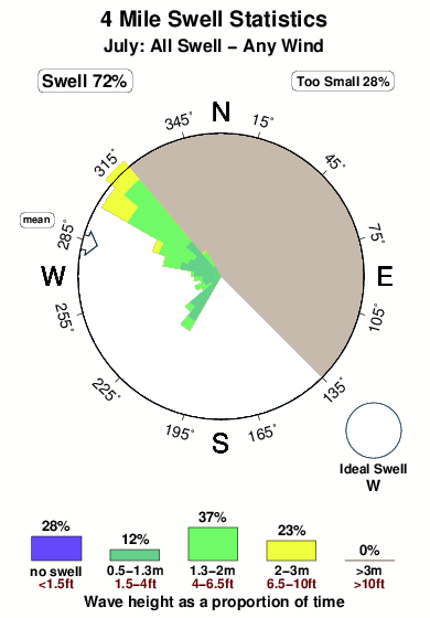
Dominante Periode (s) 8 9 - 8 Overall 4 Mile Surf Consistency and Wind Distribution in July
surffoto's uit
de galerijContourlijnen: Wegen & Rivieren: Kies een surflokatie uit het menu 


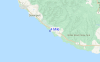
Gebruik deze reliëfkaart om naar de surfspots en de getijdenstations van CAL - Santa Cruz toe te gaan, in de buurt van 4 Mile.
Andere Dichtbijzijnde Surflocaties van 4 Mile:
(klik op locatienaam voor meer informatie)- Closest Locatie1 mi
- Second closest Locatie5 mi
- Third closest Locatie6 mi
- Fourth closest Locatie7 mi
- Fifth closest Locatie7 mi
Dichtstbijzijnde golfboeien bij 4 Mile:
- Closest golfboei19 mi
- Second closest golfboei21 mi
- Third closest golfboei28 mi
- Fourth closest golfboei45 mi
- Fifth closest golfboei47 mi
Getijdenstations in de buurt van 4 Mile:
- Closest getijdenstationSanta Cruz8 mi
- Second closest getijdenstationLive Oak10 mi
- Third closest getijdenstationAno Nuevo Island12 mi
- Fourth closest getijdenstationAptos14 mi
- Fifth closest getijdenstationRio Del Mar14 mi
Airports
- The closest passenger airport to 4 Mile is Norman Y Mineta San Jose International Airport (SJC) in USA, 47 km (29 miles) away (directly).
- The second nearest airport to 4 Mile is Moffett Federal Afld (Mountain View) Airport (NUQ), also in USA, 49 km (30 miles) away.
- Third is San Francisco International Airport (SFO) in USA, 73 km (45 miles) away.
- Metropolitan Oakland International Airport (OAK) in USA is 82 km (51 miles) away.
- Modesto City Co Harry Sham Airport (MOD), also in USA is the fifth nearest airport to 4 Mile and is 128 km (80 miles) away.
- /breaks/Four-Mile/forecasts/latest


 Nearest