
Inches Surf Guide
Inches in Puerto Rico is a fairly exposed reef break that has inconsistent surf. Ideal winds are from the east southeast. The best swell direction is from the east southeast. Even when the surf is up, crowds are unknown. Beware of - Urchins - Rips / undertow - Rocks.
Inches Spot Info
| Type: | Rating: | Reliability: | Todays Sea Temp*: |
|---|---|---|---|
| inconsistent | 28.6°C*ocean temperature recorded from satellite |
Surfing Inches:
The best conditions reported for surf at Inches occur when a East-southeast swell combines with an offshore wind direction from the East-southeast.

Voorspelde Golfenergie (Kracht): 12 uur


Inches Surf:
Tuesday, 21 July 2026, 10:46 Local time| Tuesday 21 | ||||
| 11AM | 2PM | 5PM | 8PM | |
| Wave (m) | ||||
| Periode (s) | 7 | 7 | 7 | 7 |
| Wind (km/h) | ||||
| Wind | cross- off |
cross- off |
cross- off |
cross- off |
- /breaks/Inches/forecasts/latest

Inches Surf Guide
Inches in Puerto Rico is a fairly exposed reef break that has inconsistent surf. Ideal winds are from the east southeast. The best swell direction is from the east southeast. Even when the surf is up, crowds are unknown. Beware of - Urchins - Rips / undertow - Rocks.
Inches Spot Info
Type: Rating: Reliability: Todays Sea Temp*:  Reef
Reef 4
4inconsistent 28.6°C*ocean temperature recorded from satelliteSurfing Inches:
The best conditions reported for surf at Inches occur when a East-southeast swell combines with an offshore wind direction from the East-southeast.
Voorspelde Golfenergie (Kracht): 12 uur
Gebruik de tabbladen hierboven om de zeewatertemperatuur bij Inches te bekijken, foto's van Inches, Inches gedetailleerde golfvoorspellingen, wind- en weersvoorspellingen, Inches webcams, actuele wind in Puerto Rico live weerstations en Inches getijdenvoorspellingen. De link van Puerto Rico golfkaarten opent een grote afbeelding van Puerto Rico en de omliggende zeeën. Deze golfkaarten kunnen worden dynamisch gemaakt worden met de verschillende golfcomponenten, golfenergie, golfperiode, golfhoogte, samen met de wind en weersvoorspellingen, het actuele weer en de zeetoestand volgens golfboeien uit Puerto Rico, langskomende schepen en weerstations op de kust. Elk voorspelling pagina's voor dit surfstrand zijn voorzien van een wereldwijde en regionale golfzoeker om de beste surfsomstandigheden in het gebied rond Inches te vinden.
Inches Surf:
Tuesday, 21 July 2026, 10:46 Local timeTuesday 21 11AM 2PM 5PM 8PM Wave (m) Periode (s) 7 7 7 7 Wind (km/h) Wind cross-
offcross-
offcross-
offcross-
off- /breaks/Inches/forecasts/latest
- /breaks/Inches/forecasts/latest/six_day
Inches Surf Guide
Inches in Puerto Rico is a fairly exposed reef break that has inconsistent surf. Ideal winds are from the east southeast. The best swell direction is from the east southeast. Even when the surf is up, crowds are unknown. Beware of - Urchins - Rips / undertow - Rocks.
Inches Spot Info
Type: Rating: Reliability: Todays Sea Temp*: Reef4inconsistent 28.6°C*ocean temperature recorded from satelliteSurfing Inches:
The best conditions reported for surf at Inches occur when a East-southeast swell combines with an offshore wind direction from the East-southeast.
Voorspelde Golfenergie (Kracht): 12 uur
Gebruik de tabbladen hierboven om de zeewatertemperatuur bij Inches te bekijken, foto's van Inches, Inches gedetailleerde golfvoorspellingen, wind- en weersvoorspellingen, Inches webcams, actuele wind in Puerto Rico live weerstations en Inches getijdenvoorspellingen. De link van Puerto Rico golfkaarten opent een grote afbeelding van Puerto Rico en de omliggende zeeën. Deze golfkaarten kunnen worden dynamisch gemaakt worden met de verschillende golfcomponenten, golfenergie, golfperiode, golfhoogte, samen met de wind en weersvoorspellingen, het actuele weer en de zeetoestand volgens golfboeien uit Puerto Rico, langskomende schepen en weerstations op de kust. Elk voorspelling pagina's voor dit surfstrand zijn voorzien van een wereldwijde en regionale golfzoeker om de beste surfsomstandigheden in het gebied rond Inches te vinden.
Inches Surf:
Tuesday, 21 July 2026, 10:46 Local timeTuesday 21 11AM 2PM 5PM 8PM Wave (m) Periode (s) 7 7 7 7 Wind (km/h) Wind cross-
offcross-
offcross-
offcross-
off- /breaks/Inches/forecasts/latest
Inches Surf Guide
Inches in Puerto Rico is a fairly exposed reef break that has inconsistent surf. Ideal winds are from the east southeast. The best swell direction is from the east southeast. Even when the surf is up, crowds are unknown. Beware of - Urchins - Rips / undertow - Rocks.
Inches Spot Info
Type: Rating: Reliability: Todays Sea Temp*: Reef4inconsistent 28.6°C*ocean temperature recorded from satelliteSurfing Inches:
The best conditions reported for surf at Inches occur when a East-southeast swell combines with an offshore wind direction from the East-southeast.
Voorspelde Golfenergie (Kracht): 12 uur
Gebruik de tabbladen hierboven om de zeewatertemperatuur bij Inches te bekijken, foto's van Inches, Inches gedetailleerde golfvoorspellingen, wind- en weersvoorspellingen, Inches webcams, actuele wind in Puerto Rico live weerstations en Inches getijdenvoorspellingen. De link van Puerto Rico golfkaarten opent een grote afbeelding van Puerto Rico en de omliggende zeeën. Deze golfkaarten kunnen worden dynamisch gemaakt worden met de verschillende golfcomponenten, golfenergie, golfperiode, golfhoogte, samen met de wind en weersvoorspellingen, het actuele weer en de zeetoestand volgens golfboeien uit Puerto Rico, langskomende schepen en weerstations op de kust. Elk voorspelling pagina's voor dit surfstrand zijn voorzien van een wereldwijde en regionale golfzoeker om de beste surfsomstandigheden in het gebied rond Inches te vinden.
Inches Surf:
Tuesday, 21 July 2026, 10:46 Local timeTuesday 21 11AM 2PM 5PM 8PM Wave (m) Periode (s) 7 7 7 7 Wind (km/h) Wind cross-
offcross-
offcross-
offcross-
offTide Times:
Voor Punta Tuna, Puerto Rico, %{dist} %{km} van %{location}.
VOLGENDE IS OM (lokale tijd) resterende tijd hoog water laag water Inches Tide Times and Tide Chart
Live Weather:
At Guayama, 18 km from Inches.
light winds from the N
(km/h)
dryAir temperature
31°COverall Inches Surf Consistency and Wind Distribution in July
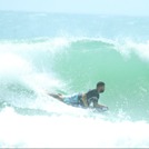
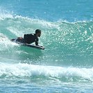
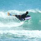
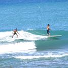
surffoto's uit
de galerijContourlijnen: Wegen & Rivieren: Kies een surflokatie uit het menu 


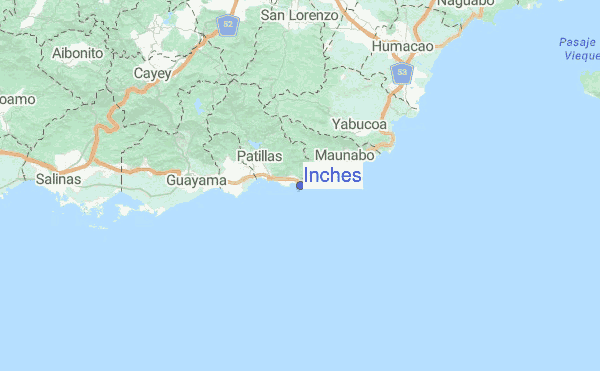
Gebruik deze reliëfkaart om naar de surfspots en de getijdenstations van Puerto Rico toe te gaan, in de buurt van Inches.
Andere Dichtbijzijnde Surflocaties van Inches:
(klik op locatienaam voor meer informatie)- Closest Locatie5 mi
- Second closest Locatie7 mi
- Third closest Locatie8 mi
- Fourth closest Locatie13 mi
- Fifth closest Locatie14 mi
Dichtstbijzijnde golfboeien bij Inches:
- Closest golfboei36 mi
- Second closest golfboei37 mi
- Third closest golfboei39 mi
- Fourth closest golfboei81 mi
- Fifth closest golfboei91 mi
Getijdenstations in de buurt van Inches:
- Closest getijdenstationPunta Tuna5 mi
- Second closest getijdenstationPuerto Maunabo6 mi
- Third closest getijdenstationArroyo7 mi
- Fourth closest getijdenstationGuayama10 mi
- Fifth closest getijdenstationYabucoa Harbor10 mi
Airports
- The closest passenger airport to Inches is Roosevelt Roads Ns Airport (NRR) in Puerto Rico, 45 km (28 miles) away (directly).
- The second nearest airport to Inches is Diego Jimenez Torres (Fajardo) Airport (FAJ), also in Puerto Rico, 49 km (30 miles) away.
- Third is Luis Munoz Marin International (San Juan) Airport (SJU) in Puerto Rico, 52 km (32 miles) away.
- Fernando Luis Ribas Dominicci (San Juan) Airport (SIG) in Puerto Rico is 56 km (35 miles) away.
- Mercedita (Ponce) Airport (PSE), also in Puerto Rico is the fifth nearest airport to Inches and is 64 km (40 miles) away.

- /breaks/Inches/forecasts/latest


 Nearest