
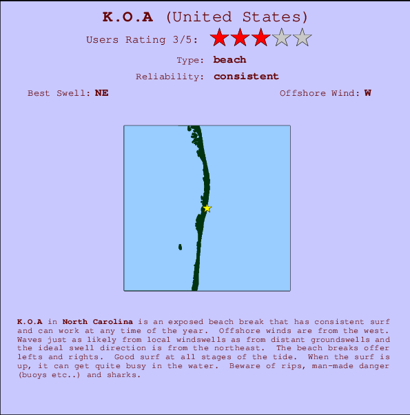
K.O.A Surf Guide
K.O.A in North Carolina is an exposed beach break that has dependable surf and can work at any time of the year. The best wind direction is from the west. Windswells and groundswells in equal measure and the ideal swell direction is from the northeast. The beach break provides left and right handers. Good surf at all stages of the tide. When the surf is up, it can get quite busy in the water. Watch out for rips, man-made danger (buoys etc...) and sharks.
K.O.A Spot Info
| Type: | Rating: | Reliability: | Todays Sea Temp*: |
|---|---|---|---|
| consistent | 26.6°C*ocean temperature recorded from satellite |
Surfing K.O.A:
The best conditions reported for surf at K.O.A occur when a Northeast swell combines with an offshore wind direction from the West.
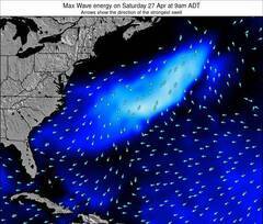
Voorspelde Golfenergie (Kracht): 12 uur
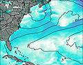

K.O.A Surf:
Saturday, 18 July 2026, 14:26 Local time| Saturday 18 | ||||
| 11AM | 2PM | 5PM | 8PM | |
| Wave (m) | ||||
| Periode (s) | 8 | 8 | 8 | 8 |
| Wind (km/h) | ||||
| Wind | cross- off |
cross- off |
cross- off |
cross- off |
- /breaks/K-O-A/forecasts/latest
K.O.A Surf Guide
K.O.A in North Carolina is an exposed beach break that has dependable surf and can work at any time of the year. The best wind direction is from the west. Windswells and groundswells in equal measure and the ideal swell direction is from the northeast. The beach break provides left and right handers. Good surf at all stages of the tide. When the surf is up, it can get quite busy in the water. Watch out for rips, man-made danger (buoys etc...) and sharks.
K.O.A Spot Info
Type: Rating: Reliability: Todays Sea Temp*:  Beach
Beach 3
3consistent 26.6°C*ocean temperature recorded from satelliteSurfing K.O.A:
The best conditions reported for surf at K.O.A occur when a Northeast swell combines with an offshore wind direction from the West.
Voorspelde Golfenergie (Kracht): 12 uur
Gebruik de tabbladen hierboven om de zeewatertemperatuur bij K.O.A te bekijken, foto's van K.O.A, K.O.A gedetailleerde golfvoorspellingen, wind- en weersvoorspellingen, K.O.A webcams, actuele wind in Carolina North live weerstations en K.O.A getijdenvoorspellingen. De link van United States golfkaarten opent een grote afbeelding van United States en de omliggende zeeën. Deze golfkaarten kunnen worden dynamisch gemaakt worden met de verschillende golfcomponenten, golfenergie, golfperiode, golfhoogte, samen met de wind en weersvoorspellingen, het actuele weer en de zeetoestand volgens golfboeien uit United States, langskomende schepen en weerstations op de kust. Elk voorspelling pagina's voor dit surfstrand zijn voorzien van een wereldwijde en regionale golfzoeker om de beste surfsomstandigheden in het gebied rond K.O.A te vinden.
K.O.A Surf:
Saturday, 18 July 2026, 14:26 Local timeSaturday 18 11AM 2PM 5PM 8PM Wave (m) Periode (s) 8 8 8 8 Wind (km/h) Wind cross-
offcross-
offcross-
offcross-
off- /breaks/K-O-A/forecasts/latest
- /breaks/K-O-A/forecasts/latest/six_day
K.O.A Surf Guide
K.O.A in North Carolina is an exposed beach break that has dependable surf and can work at any time of the year. The best wind direction is from the west. Windswells and groundswells in equal measure and the ideal swell direction is from the northeast. The beach break provides left and right handers. Good surf at all stages of the tide. When the surf is up, it can get quite busy in the water. Watch out for rips, man-made danger (buoys etc...) and sharks.
K.O.A Spot Info
Type: Rating: Reliability: Todays Sea Temp*: Beach3consistent 26.6°C*ocean temperature recorded from satelliteSurfing K.O.A:
The best conditions reported for surf at K.O.A occur when a Northeast swell combines with an offshore wind direction from the West.
Voorspelde Golfenergie (Kracht): 12 uur
Gebruik de tabbladen hierboven om de zeewatertemperatuur bij K.O.A te bekijken, foto's van K.O.A, K.O.A gedetailleerde golfvoorspellingen, wind- en weersvoorspellingen, K.O.A webcams, actuele wind in Carolina North live weerstations en K.O.A getijdenvoorspellingen. De link van United States golfkaarten opent een grote afbeelding van United States en de omliggende zeeën. Deze golfkaarten kunnen worden dynamisch gemaakt worden met de verschillende golfcomponenten, golfenergie, golfperiode, golfhoogte, samen met de wind en weersvoorspellingen, het actuele weer en de zeetoestand volgens golfboeien uit United States, langskomende schepen en weerstations op de kust. Elk voorspelling pagina's voor dit surfstrand zijn voorzien van een wereldwijde en regionale golfzoeker om de beste surfsomstandigheden in het gebied rond K.O.A te vinden.
K.O.A Surf:
Saturday, 18 July 2026, 14:26 Local timeSaturday 18 11AM 2PM 5PM 8PM Wave (m) Periode (s) 8 8 8 8 Wind (km/h) Wind cross-
offcross-
offcross-
offcross-
off- /breaks/K-O-A/forecasts/latest
K.O.A Surf Guide
K.O.A in North Carolina is an exposed beach break that has dependable surf and can work at any time of the year. The best wind direction is from the west. Windswells and groundswells in equal measure and the ideal swell direction is from the northeast. The beach break provides left and right handers. Good surf at all stages of the tide. When the surf is up, it can get quite busy in the water. Watch out for rips, man-made danger (buoys etc...) and sharks.
K.O.A Spot Info
Type: Rating: Reliability: Todays Sea Temp*: Beach3consistent 26.6°C*ocean temperature recorded from satelliteSurfing K.O.A:
The best conditions reported for surf at K.O.A occur when a Northeast swell combines with an offshore wind direction from the West.
Voorspelde Golfenergie (Kracht): 12 uur
Gebruik de tabbladen hierboven om de zeewatertemperatuur bij K.O.A te bekijken, foto's van K.O.A, K.O.A gedetailleerde golfvoorspellingen, wind- en weersvoorspellingen, K.O.A webcams, actuele wind in Carolina North live weerstations en K.O.A getijdenvoorspellingen. De link van United States golfkaarten opent een grote afbeelding van United States en de omliggende zeeën. Deze golfkaarten kunnen worden dynamisch gemaakt worden met de verschillende golfcomponenten, golfenergie, golfperiode, golfhoogte, samen met de wind en weersvoorspellingen, het actuele weer en de zeetoestand volgens golfboeien uit United States, langskomende schepen en weerstations op de kust. Elk voorspelling pagina's voor dit surfstrand zijn voorzien van een wereldwijde en regionale golfzoeker om de beste surfsomstandigheden in het gebied rond K.O.A te vinden.
K.O.A Surf:
Saturday, 18 July 2026, 14:26 Local timeSaturday 18 11AM 2PM 5PM 8PM Wave (m) Periode (s) 8 8 8 8 Wind (km/h) Wind cross-
offcross-
offcross-
offcross-
offTide Times:
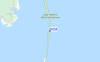
Voor Rodanthe, Pamlico Sound, North Carolina, %{dist} %{km} van %{location}.
VOLGENDE IS OM (lokale tijd) resterende tijd hoog water laag water K.O.A Tide Times and Tide Chart
Live Weather:
At Oregon Inlet- NC, 26 km from K.O.A.
- Air temperature
-°CBuoy Data:
At Oregon Inlet, NC, 16 miles from K.O.A.
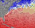
9AM 10AM 11AM 12PM Gegevens Leeftijd 4 hr 3 hr 2 hr 1 hr Golfhoogte (m) 


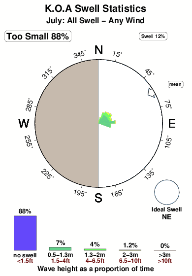
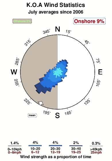
Dominante Periode (s) 14 14 13 13 Overall K.O.A Surf Consistency and Wind Distribution in July
surffoto's uit
de galerijContourlijnen: Wegen & Rivieren: Kies een surflokatie uit het menu 

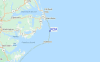
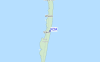
Gebruik deze reliëfkaart om naar de surfspots en de getijdenstations van Carolina North toe te gaan, in de buurt van K.O.A.
Andere Dichtbijzijnde Surflocaties van K.O.A:
(klik op locatienaam voor meer informatie)- Closest Locatie2 mi
- Second closest Locatie4 mi
- Third closest Locatie12 mi
- Fourth closest Locatie13 mi
- Fifth closest Locatie16 mi
Dichtstbijzijnde golfboeien bij K.O.A:
- Closest golfboei16 mi
- Second closest golfboei32 mi
- Third closest golfboei37 mi
- Fourth closest golfboei47 mi
- Fifth closest golfboei47 mi
Getijdenstations in de buurt van K.O.A:
- Closest getijdenstationRodanthe, Pamlico Sound4 mi
- Second closest getijdenstationAvon14 mi
- Third closest getijdenstationDavis Slough15 mi
- Fourth closest getijdenstationOregon Inlet16 mi
- Fifth closest getijdenstationOregon Inlet Bridge16 mi
Airports
- The closest passenger airport to K.O.A is Elizabeth City Cgas Rgnl Airport (ECG) in USA, 102 km (63 miles) away (directly).
- The second nearest airport to K.O.A is Cherry Point Mcas Airport (NKT), also in USA, 147 km (91 miles) away.
- Third is Oceana Nas Airport (NTU) in USA, 151 km (94 miles) away.
- Craven Co Rgnl (New Bern) Airport (EWN) in USA is 152 km (94 miles) away.
- Norfolk International Airport (ORF), also in USA is the fifth nearest airport to K.O.A and is 164 km (102 miles) away.
- /breaks/K-O-A/forecasts/latest


 Nearest