
Kololi Kotu Kombo Surf Guide
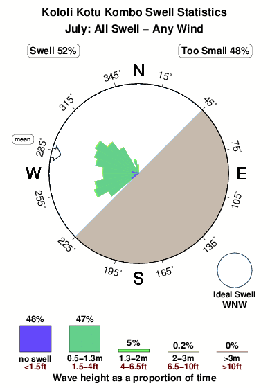
Kololi Kotu Kombo in Gambia is an exposed beach break that has very consistent surf. Works best in offshore winds from the southeast. The best swell direction is from the west northwest. The beach breaks offer lefts and rights. Rarely crowded here. Take care of - Rips / undertow.
Kololi Kotu Kombo Spot Info
| Type: | Rating: | Reliability: | Todays Sea Temp*: |
|---|---|---|---|
| very consistent | 29.3°C*ocean temperature recorded from satellite |
Surfing Kololi Kotu Kombo:
The best conditions reported for surf at Kololi Kotu Kombo occur when a West-northwest swell combines with an offshore wind direction from the Southeast.
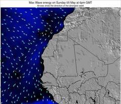
Voorspelde Golfenergie (Kracht): 12 uur
Kololi Kotu Kombo Surf:
Friday, 17 July 2026, 10:06 Local time| Friday 17 | ||||
| 9AM | 12PM | 3PM | 6PM | |
| Wave (m) | ||||
| Periode (s) | 7 | 7 | 7 | 16 |
| Wind (km/h) | ||||
| Wind | cross- off |
cross | cross | cross |
- /breaks/Kololi-Kotu-Kombo/forecasts/latest

Kololi Kotu Kombo Surf Guide
Kololi Kotu Kombo in Gambia is an exposed beach break that has very consistent surf. Works best in offshore winds from the southeast. The best swell direction is from the west northwest. The beach breaks offer lefts and rights. Rarely crowded here. Take care of - Rips / undertow.
Kololi Kotu Kombo Spot Info
Type: Rating: Reliability: Todays Sea Temp*:  Beach
Beach 1
1very consistent 29.3°C*ocean temperature recorded from satelliteSurfing Kololi Kotu Kombo:
The best conditions reported for surf at Kololi Kotu Kombo occur when a West-northwest swell combines with an offshore wind direction from the Southeast.
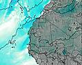
Voorspelde Golfenergie (Kracht): 12 uur
Gebruik de tabbladen hierboven om de zeewatertemperatuur bij Kololi Kotu Kombo te bekijken, foto's van Kololi Kotu Kombo, Kololi Kotu Kombo gedetailleerde golfvoorspellingen, wind- en weersvoorspellingen, Kololi Kotu Kombo webcams, actuele wind in Gambia live weerstations en Kololi Kotu Kombo getijdenvoorspellingen. De link van Gambia golfkaarten opent een grote afbeelding van Gambia en de omliggende zeeën. Deze golfkaarten kunnen worden dynamisch gemaakt worden met de verschillende golfcomponenten, golfenergie, golfperiode, golfhoogte, samen met de wind en weersvoorspellingen, het actuele weer en de zeetoestand volgens golfboeien uit Gambia, langskomende schepen en weerstations op de kust. Elk voorspelling pagina's voor dit surfstrand zijn voorzien van een wereldwijde en regionale golfzoeker om de beste surfsomstandigheden in het gebied rond Kololi Kotu Kombo te vinden.
Kololi Kotu Kombo Surf:
Friday, 17 July 2026, 10:06 Local timeFriday 17 9AM 12PM 3PM 6PM Wave (m) Periode (s) 7 7 7 16 Wind (km/h) Wind cross-
offcross cross cross - /breaks/Kololi-Kotu-Kombo/forecasts/latest
- /breaks/Kololi-Kotu-Kombo/forecasts/latest/six_day
Kololi Kotu Kombo Surf Guide
Kololi Kotu Kombo in Gambia is an exposed beach break that has very consistent surf. Works best in offshore winds from the southeast. The best swell direction is from the west northwest. The beach breaks offer lefts and rights. Rarely crowded here. Take care of - Rips / undertow.
Kololi Kotu Kombo Spot Info
Type: Rating: Reliability: Todays Sea Temp*: Beach1very consistent 29.3°C*ocean temperature recorded from satelliteSurfing Kololi Kotu Kombo:
The best conditions reported for surf at Kololi Kotu Kombo occur when a West-northwest swell combines with an offshore wind direction from the Southeast.
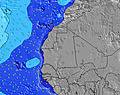
Voorspelde Golfenergie (Kracht): 12 uur
Gebruik de tabbladen hierboven om de zeewatertemperatuur bij Kololi Kotu Kombo te bekijken, foto's van Kololi Kotu Kombo, Kololi Kotu Kombo gedetailleerde golfvoorspellingen, wind- en weersvoorspellingen, Kololi Kotu Kombo webcams, actuele wind in Gambia live weerstations en Kololi Kotu Kombo getijdenvoorspellingen. De link van Gambia golfkaarten opent een grote afbeelding van Gambia en de omliggende zeeën. Deze golfkaarten kunnen worden dynamisch gemaakt worden met de verschillende golfcomponenten, golfenergie, golfperiode, golfhoogte, samen met de wind en weersvoorspellingen, het actuele weer en de zeetoestand volgens golfboeien uit Gambia, langskomende schepen en weerstations op de kust. Elk voorspelling pagina's voor dit surfstrand zijn voorzien van een wereldwijde en regionale golfzoeker om de beste surfsomstandigheden in het gebied rond Kololi Kotu Kombo te vinden.
Kololi Kotu Kombo Surf:
Friday, 17 July 2026, 10:06 Local timeFriday 17 9AM 12PM 3PM 6PM Wave (m) Periode (s) 7 7 7 16 Wind (km/h) Wind cross-
offcross cross cross - /breaks/Kololi-Kotu-Kombo/forecasts/latest
Kololi Kotu Kombo Surf Guide
Kololi Kotu Kombo in Gambia is an exposed beach break that has very consistent surf. Works best in offshore winds from the southeast. The best swell direction is from the west northwest. The beach breaks offer lefts and rights. Rarely crowded here. Take care of - Rips / undertow.
Kololi Kotu Kombo Spot Info
Type: Rating: Reliability: Todays Sea Temp*: Beach1very consistent 29.3°C*ocean temperature recorded from satelliteSurfing Kololi Kotu Kombo:
The best conditions reported for surf at Kololi Kotu Kombo occur when a West-northwest swell combines with an offshore wind direction from the Southeast.
Voorspelde Golfenergie (Kracht): 12 uur
Gebruik de tabbladen hierboven om de zeewatertemperatuur bij Kololi Kotu Kombo te bekijken, foto's van Kololi Kotu Kombo, Kololi Kotu Kombo gedetailleerde golfvoorspellingen, wind- en weersvoorspellingen, Kololi Kotu Kombo webcams, actuele wind in Gambia live weerstations en Kololi Kotu Kombo getijdenvoorspellingen. De link van Gambia golfkaarten opent een grote afbeelding van Gambia en de omliggende zeeën. Deze golfkaarten kunnen worden dynamisch gemaakt worden met de verschillende golfcomponenten, golfenergie, golfperiode, golfhoogte, samen met de wind en weersvoorspellingen, het actuele weer en de zeetoestand volgens golfboeien uit Gambia, langskomende schepen en weerstations op de kust. Elk voorspelling pagina's voor dit surfstrand zijn voorzien van een wereldwijde en regionale golfzoeker om de beste surfsomstandigheden in het gebied rond Kololi Kotu Kombo te vinden.
Kololi Kotu Kombo Surf:
Friday, 17 July 2026, 10:06 Local timeFriday 17 9AM 12PM 3PM 6PM Wave (m) Periode (s) 7 7 7 16 Wind (km/h) Wind cross-
offcross cross cross Tide Times:
Voor Sukuta, %{dist} %{km} van %{location}.
VOLGENDE IS OM (lokale tijd) resterende tijd hoog water laag water Kololi Kotu Kombo Tide Times and Tide Chart
Live Weather:
At Banjul/Yundum International Airport, 11 km from Kololi Kotu Kombo.
calm
(km/h)
Dry and partly cloudyAir temperature
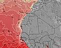
27°COverall Kololi Kotu Kombo Surf Consistency and Wind Distribution in July
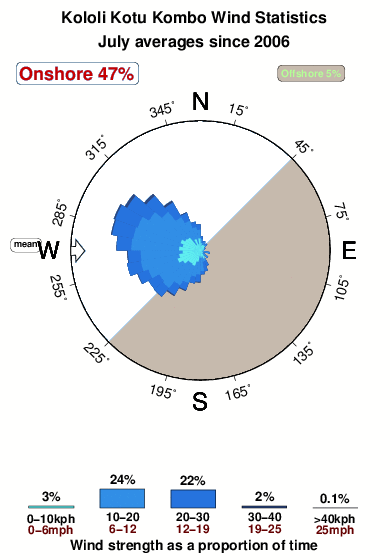


Wind stats for Kololi Kotu Kombo: see the variation in direction and stength by month.
surffoto's uit
de galerijContourlijnen: Wegen & Rivieren: Kies een surflokatie uit het menu 


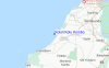
Gebruik deze reliëfkaart om naar de surfspots en de getijdenstations van Gambia toe te gaan, in de buurt van Kololi Kotu Kombo.
Andere Dichtbijzijnde Surflocaties van Kololi Kotu Kombo:
(klik op locatienaam voor meer informatie)- Closest Locatie2 mi
- Second closest Locatie73 mi
- Third closest Locatie76 mi
- Fourth closest Locatie83 mi
- Fifth closest Locatie100 mi
Dichtstbijzijnde golfboeien bij Kololi Kotu Kombo:
- Closest golfboei1329 mi
- Second closest golfboei1334 mi
- Third closest golfboei1475 mi
- Fourth closest golfboei1713 mi
- Fifth closest golfboei1761 mi
Getijdenstations in de buurt van Kololi Kotu Kombo:
- Closest getijdenstationSukuta2 mi
- Second closest getijdenstationBakau6 mi
- Third closest getijdenstationBanjul, Gambia11 mi
- Fourth closest getijdenstationBarra14 mi
- Fifth closest getijdenstationEssau15 mi
Airports
- The closest passenger airport to Kololi Kotu Kombo is Banjul International Airport (BJL) in Gambia, 13 km (8 miles) away (directly).
- The second nearest airport to Kololi Kotu Kombo is Ziguinchor Airport (ZIG) in Senegal, 108 km (67 miles) away.
- Third is Kaolack Airport (KLC) in Senegal, 111 km (69 miles) away.
- Cap Skiring Airport (CSK) in Senegal is 112 km (70 miles) away.
- Leopold Sedar Senghor International (Dakar) Airport (DKR), also in Senegal is the fifth nearest airport to Kololi Kotu Kombo and is 168 km (104 miles) away.

- /breaks/Kololi-Kotu-Kombo/forecasts/latest

 Nearest