
Rogues Bay - Lava Flows Surf Guide
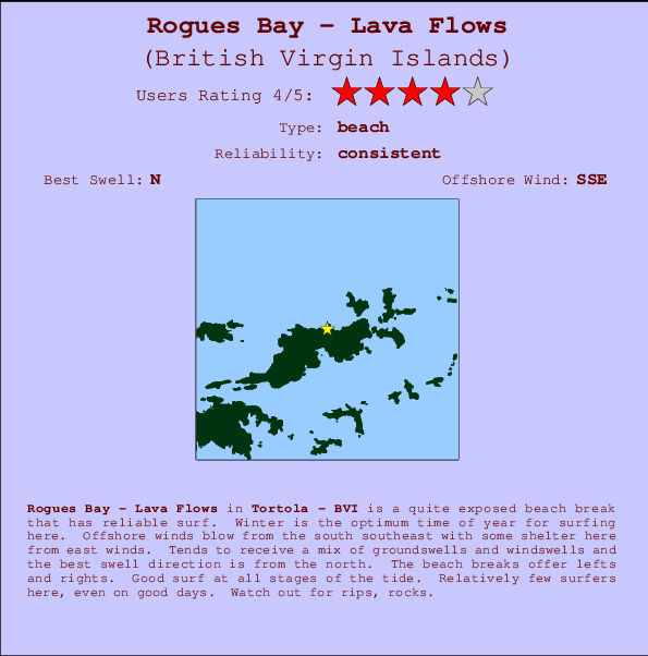
Rogues Bay - Lava Flows in Tortola - BVI is a reasonably exposed beach break that usually has waves. Winter is the best time of year for surfing here. Ideal winds are from the south southeast with some shelter here from east winds. Windswells and groundswells in equal measure and the ideal swell angle is from the north. The beach breaks offer lefts and rights. The quality of the surf isn't affected by the tide. Even when there are waves, it's not likley to be crowded. Beware of rips, rocks.
Rogues Bay - Lava Flows Spot Info
| Type: | Rating: | Reliability: | Todays Sea Temp*: |
|---|---|---|---|
| consistent | 28.4°C*ocean temperature recorded from satellite |
Surfing Rogues Bay - Lava Flows:
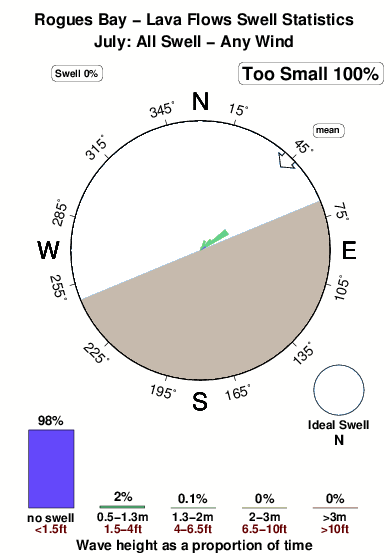
The best conditions reported for surf at Rogues Bay - Lava Flows occur when a North swell combines with an offshore wind direction from the South-southeast.

Voorspelde Golfenergie (Kracht): 12 uur


Rogues Bay - Lava Flows Surf:
Saturday, 18 July 2026, 03:08 Local time| Fri | Saturday 18 | |||
| 11PM | 2AM | 5AM | 8AM | |
| Wave (m) | ||||
| Periode (s) | 7 | 7 | 7 | 7 |
| Wind (km/h) | ||||
| Wind | cross- off |
cross- off |
cross- off |
cross- off |
- /breaks/Lava-Flows/forecasts/latest
Rogues Bay - Lava Flows Surf Guide
Rogues Bay - Lava Flows in Tortola - BVI is a reasonably exposed beach break that usually has waves. Winter is the best time of year for surfing here. Ideal winds are from the south southeast with some shelter here from east winds. Windswells and groundswells in equal measure and the ideal swell angle is from the north. The beach breaks offer lefts and rights. The quality of the surf isn't affected by the tide. Even when there are waves, it's not likley to be crowded. Beware of rips, rocks.
Rogues Bay - Lava Flows Spot Info
Type: Rating: Reliability: Todays Sea Temp*:  Beach
Beach 4
4consistent 28.4°C*ocean temperature recorded from satelliteSurfing Rogues Bay - Lava Flows:
The best conditions reported for surf at Rogues Bay - Lava Flows occur when a North swell combines with an offshore wind direction from the South-southeast.
Voorspelde Golfenergie (Kracht): 12 uur
Gebruik de tabbladen hierboven om de zeewatertemperatuur bij Rogues Bay - Lava Flows te bekijken, foto's van Rogues Bay - Lava Flows, Rogues Bay - Lava Flows gedetailleerde golfvoorspellingen, wind- en weersvoorspellingen, Rogues Bay - Lava Flows webcams, actuele wind in Tortola live weerstations en Rogues Bay - Lava Flows getijdenvoorspellingen. De link van British Virgin Islands golfkaarten opent een grote afbeelding van British Virgin Islands en de omliggende zeeën. Deze golfkaarten kunnen worden dynamisch gemaakt worden met de verschillende golfcomponenten, golfenergie, golfperiode, golfhoogte, samen met de wind en weersvoorspellingen, het actuele weer en de zeetoestand volgens golfboeien uit British Virgin Islands, langskomende schepen en weerstations op de kust. Elk voorspelling pagina's voor dit surfstrand zijn voorzien van een wereldwijde en regionale golfzoeker om de beste surfsomstandigheden in het gebied rond Rogues Bay - Lava Flows te vinden.
Rogues Bay - Lava Flows Surf:
Saturday, 18 July 2026, 03:08 Local timeFri Saturday 18 11PM 2AM 5AM 8AM Wave (m) Periode (s) 7 7 7 7 Wind (km/h) Wind cross-
offcross-
offcross-
offcross-
off- /breaks/Lava-Flows/forecasts/latest
- /breaks/Lava-Flows/forecasts/latest/six_day
Rogues Bay - Lava Flows Surf Guide
Rogues Bay - Lava Flows in Tortola - BVI is a reasonably exposed beach break that usually has waves. Winter is the best time of year for surfing here. Ideal winds are from the south southeast with some shelter here from east winds. Windswells and groundswells in equal measure and the ideal swell angle is from the north. The beach breaks offer lefts and rights. The quality of the surf isn't affected by the tide. Even when there are waves, it's not likley to be crowded. Beware of rips, rocks.
Rogues Bay - Lava Flows Spot Info
Type: Rating: Reliability: Todays Sea Temp*: Beach4consistent 28.4°C*ocean temperature recorded from satelliteSurfing Rogues Bay - Lava Flows:
The best conditions reported for surf at Rogues Bay - Lava Flows occur when a North swell combines with an offshore wind direction from the South-southeast.
Voorspelde Golfenergie (Kracht): 12 uur
Gebruik de tabbladen hierboven om de zeewatertemperatuur bij Rogues Bay - Lava Flows te bekijken, foto's van Rogues Bay - Lava Flows, Rogues Bay - Lava Flows gedetailleerde golfvoorspellingen, wind- en weersvoorspellingen, Rogues Bay - Lava Flows webcams, actuele wind in Tortola live weerstations en Rogues Bay - Lava Flows getijdenvoorspellingen. De link van British Virgin Islands golfkaarten opent een grote afbeelding van British Virgin Islands en de omliggende zeeën. Deze golfkaarten kunnen worden dynamisch gemaakt worden met de verschillende golfcomponenten, golfenergie, golfperiode, golfhoogte, samen met de wind en weersvoorspellingen, het actuele weer en de zeetoestand volgens golfboeien uit British Virgin Islands, langskomende schepen en weerstations op de kust. Elk voorspelling pagina's voor dit surfstrand zijn voorzien van een wereldwijde en regionale golfzoeker om de beste surfsomstandigheden in het gebied rond Rogues Bay - Lava Flows te vinden.
Rogues Bay - Lava Flows Surf:
Saturday, 18 July 2026, 03:08 Local timeFri Saturday 18 11PM 2AM 5AM 8AM Wave (m) Periode (s) 7 7 7 7 Wind (km/h) Wind cross-
offcross-
offcross-
offcross-
off- /breaks/Lava-Flows/forecasts/latest
Rogues Bay - Lava Flows Surf Guide
Rogues Bay - Lava Flows in Tortola - BVI is a reasonably exposed beach break that usually has waves. Winter is the best time of year for surfing here. Ideal winds are from the south southeast with some shelter here from east winds. Windswells and groundswells in equal measure and the ideal swell angle is from the north. The beach breaks offer lefts and rights. The quality of the surf isn't affected by the tide. Even when there are waves, it's not likley to be crowded. Beware of rips, rocks.
Rogues Bay - Lava Flows Spot Info
Type: Rating: Reliability: Todays Sea Temp*: Beach4consistent 28.4°C*ocean temperature recorded from satelliteSurfing Rogues Bay - Lava Flows:
The best conditions reported for surf at Rogues Bay - Lava Flows occur when a North swell combines with an offshore wind direction from the South-southeast.
Voorspelde Golfenergie (Kracht): 12 uur
Gebruik de tabbladen hierboven om de zeewatertemperatuur bij Rogues Bay - Lava Flows te bekijken, foto's van Rogues Bay - Lava Flows, Rogues Bay - Lava Flows gedetailleerde golfvoorspellingen, wind- en weersvoorspellingen, Rogues Bay - Lava Flows webcams, actuele wind in Tortola live weerstations en Rogues Bay - Lava Flows getijdenvoorspellingen. De link van British Virgin Islands golfkaarten opent een grote afbeelding van British Virgin Islands en de omliggende zeeën. Deze golfkaarten kunnen worden dynamisch gemaakt worden met de verschillende golfcomponenten, golfenergie, golfperiode, golfhoogte, samen met de wind en weersvoorspellingen, het actuele weer en de zeetoestand volgens golfboeien uit British Virgin Islands, langskomende schepen en weerstations op de kust. Elk voorspelling pagina's voor dit surfstrand zijn voorzien van een wereldwijde en regionale golfzoeker om de beste surfsomstandigheden in het gebied rond Rogues Bay - Lava Flows te vinden.
Rogues Bay - Lava Flows Surf:
Saturday, 18 July 2026, 03:08 Local timeFri Saturday 18 11PM 2AM 5AM 8AM Wave (m) Periode (s) 7 7 7 7 Wind (km/h) Wind cross-
offcross-
offcross-
offcross-
offTide Times:
Voor Road Town, %{dist} %{km} van %{location}.
VOLGENDE IS OM (lokale tijd) resterende tijd hoog water laag water Rogues Bay - Lava Flows Tide Times and Tide Chart
Live Weather:
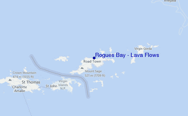
At St Thomas, 37 km from Rogues Bay - Lava Flows.
-
dryAir temperature
-°COverall Rogues Bay - Lava Flows Surf Consistency and Wind Distribution in July
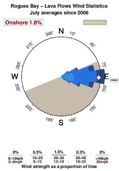

Wind stats for Rogues Bay - Lava Flows: see the variation in direction and stength by month.
surffoto's uit
de galerijContourlijnen: Wegen & Rivieren: Kies een surflokatie uit het menu 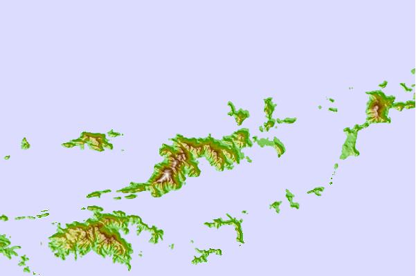
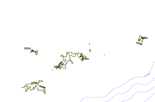
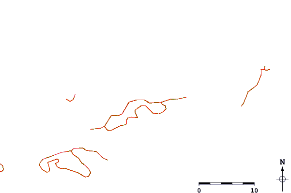
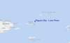
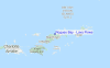
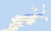
Gebruik deze reliëfkaart om naar de surfspots en de getijdenstations van Tortola toe te gaan, in de buurt van Rogues Bay - Lava Flows.
Andere Dichtbijzijnde Surflocaties van Rogues Bay - Lava Flows:
(klik op locatienaam voor meer informatie)- Closest Locatie0 mi
- Second closest Locatie1 mi
- Third closest Locatie1 mi
- Fourth closest Locatie1 mi
- Fifth closest Locatie2 mi
Dichtstbijzijnde golfboeien bij Rogues Bay - Lava Flows:
- Closest golfboei17 mi
- Second closest golfboei58 mi
- Third closest golfboei98 mi
- Fourth closest golfboei132 mi
- Fifth closest golfboei154 mi
Getijdenstations in de buurt van Rogues Bay - Lava Flows:
- Closest getijdenstationRoad Town3 mi
- Second closest getijdenstationCoral Harbor, Saint Johns Island10 mi
- Third closest getijdenstationLameshur Bay, Saint Johns12 mi
- Fourth closest getijdenstationRedhook Bay, Saint Thomas Island19 mi
- Fifth closest getijdenstationBenner Bay, Saint Thomas19 mi
Airports
- The closest passenger airport to Rogues Bay - Lava Flows is Terrance B Lettsome International (Roadtown/beef Island) Airport (EIS) in Virgin Isl., 7 km (4 miles) away (directly).
- The second nearest airport to Rogues Bay - Lava Flows is Cyril E King (St. Thomas) Airport (STT), also in Virgin Isl., 41 km (25 miles) away.
- Third is Henry E Rohlsen (St. Criox Island) Airport (STX) in Virgin Isl., 86 km (53 miles) away.
- Diego Jimenez Torres (Fajardo) Airport (FAJ) in Puerto Rico is 112 km (70 miles) away.
- Roosevelt Roads Ns Airport (NRR), also in Puerto Rico is the fifth nearest airport to Rogues Bay - Lava Flows and is 112 km (70 miles) away.
- /breaks/Lava-Flows/forecasts/latest
 Nearest