
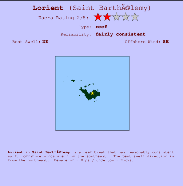
Lorient Surf Guide
Lorient in Saint Barthélemy is a reasonably exposed reef break that has reasonably consistent surf. The best wind direction is from the southeast. The best swell direction is from the northeast. Beware of - Rips / undertow - Rocks.
Lorient Spot Info
| Type: | Rating: | Reliability: | Todays Sea Temp*: |
|---|---|---|---|
| fairly consistent | 28.5°C*ocean temperature recorded from satellite |
Surfing Lorient:
The best conditions reported for surf at Lorient occur when a Northeast swell combines with an offshore wind direction from the Southeast.

Voorspelde Golfenergie (Kracht): 12 uur


Lorient Surf:
Sunday, 26 July 2026, 16:38 Local time| Sunday 26 | Mon | |||
| 5PM | 8PM | 11PM | 2AM | |
| Wave (m) | ||||
| Periode (s) | 8 | 8 | 8 | 7 |
| Wind (km/h) | ||||
| Wind | cross- off |
cross- off |
cross- off |
cross- off |
- /breaks/Lorient/forecasts/latest

Lorient Surf Guide
Lorient in Saint Barthélemy is a reasonably exposed reef break that has reasonably consistent surf. The best wind direction is from the southeast. The best swell direction is from the northeast. Beware of - Rips / undertow - Rocks.
Lorient Spot Info
Type: Rating: Reliability: Todays Sea Temp*:  Reef
Reef 2
2fairly consistent 28.5°C*ocean temperature recorded from satelliteSurfing Lorient:
The best conditions reported for surf at Lorient occur when a Northeast swell combines with an offshore wind direction from the Southeast.
Voorspelde Golfenergie (Kracht): 12 uur
Gebruik de tabbladen hierboven om de zeewatertemperatuur bij Lorient te bekijken, foto's van Lorient, Lorient gedetailleerde golfvoorspellingen, wind- en weersvoorspellingen, Lorient webcams, actuele wind in Saint Barthélemy live weerstations en Lorient getijdenvoorspellingen. De link van Saint Barthélemy golfkaarten opent een grote afbeelding van Saint Barthélemy en de omliggende zeeën. Deze golfkaarten kunnen worden dynamisch gemaakt worden met de verschillende golfcomponenten, golfenergie, golfperiode, golfhoogte, samen met de wind en weersvoorspellingen, het actuele weer en de zeetoestand volgens golfboeien uit Saint Barthélemy, langskomende schepen en weerstations op de kust. Elk voorspelling pagina's voor dit surfstrand zijn voorzien van een wereldwijde en regionale golfzoeker om de beste surfsomstandigheden in het gebied rond Lorient te vinden.
Lorient Surf:
Sunday, 26 July 2026, 16:38 Local timeSunday 26 Mon 5PM 8PM 11PM 2AM Wave (m) Periode (s) 8 8 8 7 Wind (km/h) Wind cross-
offcross-
offcross-
offcross-
off- /breaks/Lorient/forecasts/latest
- /breaks/Lorient/forecasts/latest/six_day
Lorient Surf Guide
Lorient in Saint Barthélemy is a reasonably exposed reef break that has reasonably consistent surf. The best wind direction is from the southeast. The best swell direction is from the northeast. Beware of - Rips / undertow - Rocks.
Lorient Spot Info
Type: Rating: Reliability: Todays Sea Temp*: Reef2fairly consistent 28.5°C*ocean temperature recorded from satelliteSurfing Lorient:
The best conditions reported for surf at Lorient occur when a Northeast swell combines with an offshore wind direction from the Southeast.
Voorspelde Golfenergie (Kracht): 12 uur
Gebruik de tabbladen hierboven om de zeewatertemperatuur bij Lorient te bekijken, foto's van Lorient, Lorient gedetailleerde golfvoorspellingen, wind- en weersvoorspellingen, Lorient webcams, actuele wind in Saint Barthélemy live weerstations en Lorient getijdenvoorspellingen. De link van Saint Barthélemy golfkaarten opent een grote afbeelding van Saint Barthélemy en de omliggende zeeën. Deze golfkaarten kunnen worden dynamisch gemaakt worden met de verschillende golfcomponenten, golfenergie, golfperiode, golfhoogte, samen met de wind en weersvoorspellingen, het actuele weer en de zeetoestand volgens golfboeien uit Saint Barthélemy, langskomende schepen en weerstations op de kust. Elk voorspelling pagina's voor dit surfstrand zijn voorzien van een wereldwijde en regionale golfzoeker om de beste surfsomstandigheden in het gebied rond Lorient te vinden.
Lorient Surf:
Sunday, 26 July 2026, 16:38 Local timeSunday 26 Mon 5PM 8PM 11PM 2AM Wave (m) Periode (s) 8 8 8 7 Wind (km/h) Wind cross-
offcross-
offcross-
offcross-
off- /breaks/Lorient/forecasts/latest
Lorient Surf Guide
Lorient in Saint Barthélemy is a reasonably exposed reef break that has reasonably consistent surf. The best wind direction is from the southeast. The best swell direction is from the northeast. Beware of - Rips / undertow - Rocks.
Lorient Spot Info
Type: Rating: Reliability: Todays Sea Temp*: Reef2fairly consistent 28.5°C*ocean temperature recorded from satelliteSurfing Lorient:
The best conditions reported for surf at Lorient occur when a Northeast swell combines with an offshore wind direction from the Southeast.
Voorspelde Golfenergie (Kracht): 12 uur
Gebruik de tabbladen hierboven om de zeewatertemperatuur bij Lorient te bekijken, foto's van Lorient, Lorient gedetailleerde golfvoorspellingen, wind- en weersvoorspellingen, Lorient webcams, actuele wind in Saint Barthélemy live weerstations en Lorient getijdenvoorspellingen. De link van Saint Barthélemy golfkaarten opent een grote afbeelding van Saint Barthélemy en de omliggende zeeën. Deze golfkaarten kunnen worden dynamisch gemaakt worden met de verschillende golfcomponenten, golfenergie, golfperiode, golfhoogte, samen met de wind en weersvoorspellingen, het actuele weer en de zeetoestand volgens golfboeien uit Saint Barthélemy, langskomende schepen en weerstations op de kust. Elk voorspelling pagina's voor dit surfstrand zijn voorzien van een wereldwijde en regionale golfzoeker om de beste surfsomstandigheden in het gebied rond Lorient te vinden.
Lorient Surf:
Sunday, 26 July 2026, 16:38 Local timeSunday 26 Mon 5PM 8PM 11PM 2AM Wave (m) Periode (s) 8 8 8 7 Wind (km/h) Wind cross-
offcross-
offcross-
offcross-
offTide Times:
Voor Saint Barthelemy, Guadeloupe, %{dist} %{km} van %{location}.
VOLGENDE IS OM (lokale tijd) resterende tijd hoog water laag water Lorient Tide Times and Tide Chart
Live Weather:
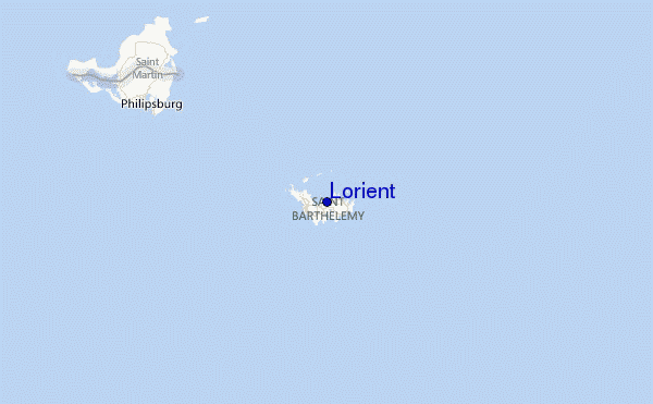
At Gustavia/st.bart, 3 km from Lorient.
fresh winds from the NE
(km/h)Air temperature
31°CBuoy Data:
At Eastern Caribbean Buoy, 107 miles from Lorient.
12PM 1PM 2PM 3PM Gegevens Leeftijd 4 hr 3 hr 2 hr 1 hr Golfhoogte (m) 


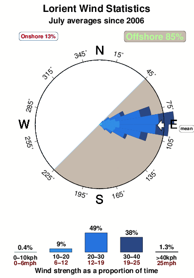
Dominante Periode (s) 5 5 5 5 Overall Lorient Surf Consistency and Wind Distribution in July
surffoto's uit
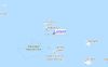
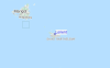
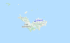
de galerijContourlijnen: Wegen & Rivieren: Kies een surflokatie uit het menu 

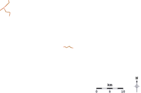
Gebruik deze reliëfkaart om naar de surfspots en de getijdenstations van Saint Barthélemy toe te gaan, in de buurt van Lorient.
Andere Dichtbijzijnde Surflocaties van Lorient:
(klik op locatienaam voor meer informatie)- Closest Locatie0 mi
- Second closest Locatie1 mi
- Third closest Locatie1 mi
- Fourth closest Locatie1 mi
- Fifth closest Locatie1 mi
Dichtstbijzijnde golfboeien bij Lorient:
- Closest golfboei107 mi
- Second closest golfboei129 mi
- Third closest golfboei175 mi
- Fourth closest golfboei219 mi
- Fifth closest golfboei243 mi
Getijdenstations in de buurt van Lorient:
- Closest getijdenstationSaint Barthelemy2 mi
- Second closest getijdenstationDuth Cul de Sac18 mi
- Third closest getijdenstationMarigot21 mi
- Fourth closest getijdenstationBasseterre43 mi
- Fifth closest getijdenstationSaint Johns, Antigua83 mi
Airports
- The closest passenger airport to Lorient is Gustavia/st.barthel (St.-barthelemy) Airport (SBH) in Antilles, 3 km (2 miles) away (directly).
- The second nearest airport to Lorient is Grand Case (St. Martin) Airport (SFG), also in Antilles, 32 km (20 miles) away.
- Third is Princess Juliana International (Philipsburg) Airport (SXM) in Antilles, 33 km (20 miles) away.
- Wallblake (The Valley) Airport (AXA) in Anguilla Isl. is 41 km (25 miles) away.
- F D Roosevelt (Oranjestad) Airport (EUX) in Antilles is the fifth nearest airport to Lorient and is 49 km (30 miles) away.
- /breaks/Lorient/forecasts/latest


 Nearest