
Golfvoorspellingen:

Voorspelling Lange TermijnMeestal droog. Warm (max 24°C op donderdagochtend, min 19°C op vrijdagavond). Wind zal licht zijn over het algemeen. | ||||||||||||||||||||||||
Thursday 16 | Friday 17 | Saturday 18 | Sun 19 | |||||||||||||||||||||
4 AM | 7 AM | 10 AM | 1 PM | 4 PM | 7 PM | 10 PM | 1 AM | 4 AM | 7 AM | 10 AM | 1 PM | 4 PM | 7 PM | 10 PM | 1 AM | 4 AM | 7 AM | 10 AM | 1 PM | 4 PM | 7 PM | 10 PM | 1 AM | |
Golfhoogte kaart |  |  | 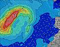 |  | 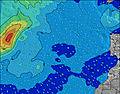 |  |  | 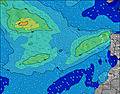 |  | 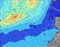 | ||||||||||||||
Golf Hoogte (m) Richting Periode (s) | W 9 | SSW 12 | W 8 | W 8 | W 8 | W 8 | WNW 8 | WNW 8 | SSW 11 | WNW 8 | WNW 8 | S 11 | SSW 13 | SSW 13 | SSW 19 | SSW 19 | SSW 19 | SSW 19 | SSW 12 | WNW 9 | WNW 9 | SSW 18 | SSW 18 | SSW 18 |
Golf Grafiek | ||||||||||||||||||||||||
56 | 46 | 36 | 35 | 34 | 33 | 22 | 22 | 24 | 21 | 12 | 11 | 17 | 16 | 37 | 74 | 74 | 37 | 13 | 17 | 31 | 61 | 61 | 61 | |
Wind (km/h) | ||||||||||||||||||||||||
Wind onshore cross-onshore cross-shore cross-offshore offshore glasachtig | cross | glassy | glassy | glassy | glassy | glassy | glassy | glassy | off | off | off | glassy | off | cross-off | off | off | off | off | cross-off | glassy | glassy | cross-off | off | off |
Vloed | 4:02AM2.09m | 4:19PM2.37m | 4:48AM2.05m | 5:04PM2.30m | 5:32AM1.96m | 5:49PM2.18m | ||||||||||||||||||
Eb | 10:01AM0.09m | 10:39PM-0.01m | 10:45AM0.13m | 11:24PM0.08m | 11:28AM0.22m | 00:08AM0.21m | ||||||||||||||||||
— | 7:11 | — | — | — | — | — | — | — | 7:11 | — | — | — | — | — | — | — | 7:13 | — | — | — | — | — | 7:13 | |
— | — | — | — | — | 9:15 | — | — | — | — | — | — | — | 9:15 | — | — | — | — | — | — | — | 9:15 | — | 9:15 | |
mm | — | — | — | — | — | — | — | — | — | — | — | — | — | — | — | — | — | — | — | — | — | — | — | — |
Temp. °C | 22 | 22 | 23 | 24 | 24 | 24 | 23 | 22 | 22 | 22 | 22 | 24 | 24 | 23 | 21 | 20 | 20 | 19 | 22 | 24 | 24 | 23 | 21 | 20 |
Chill °C | 25 | 25 | 26 | 28 | 27 | 27 | 26 | 25 | 25 | 25 | 24 | 27 | 26 | 25 | 23 | 21 | 21 | 20 | 23 | 26 | 27 | 25 | 22 | 21 |
Swell 1 Hoogte (m) Richting Periode (s) | W 9 | W 9 | W 8 | W 8 | W 8 | W 8 | WNW 8 | WNW 8 | N 4 | WNW 8 | WNW 8 | WNW 7 | WNW 8 | WNW 8 | WNW 8 | WNW 8 | WNW 8 | WNW 8 | WNW 10 | WNW 9 | WNW 9 | WNW 9 | WNW 9 | WNW 8 |
56 | 38 | 36 | 35 | 34 | 33 | 22 | 22 | 9 | 21 | 12 | 11 | 11 | 12 | 12 | 12 | 12 | 11 | 9 | 17 | 28 | 26 | 25 | 24 | |
Swell 2 Hoogte (m) Richting Periode (s) | SSW 12 | SSW 12 | SSW 12 | SSW 12 | SSW 12 | N 7 | NW 7 | NW 4 | WNW 8 | S 11 | S 11 | N 7 | SSW 13 | SSW 13 | SSW 19 | SSW 19 | SSW 19 | SSW 12 | WNW 7 | SSW 11 | SSW 18 | SSW 18 | SSW 18 | SSW 18 |
46 | 46 | 27 | 27 | 27 | 9 | 14 | 3 | 21 | 9 | 9 | 4 | 17 | 16 | 37 | 74 | 74 | 14 | 5 | 12 | 31 | 61 | 61 | 61 | |
Swell 3 Hoogte (m) Richting Periode (s) | N 8 | N 8 | NNE 10 | NNE 8 | NNE 9 | SSW 12 | NNE 8 | N 6 | SSW 11 | N 7 | N 7 | S 11 | N 7 | N 7 | SSW 12 | S 12 | SSW 12 | SSW 19 | SSW 12 | WNW 7 | S 11 | SSW 11 | SSW 11 | SSW 11 |
18 | 18 | 19 | 14 | 15 | 27 | 14 | 7 | 24 | 4 | 4 | 9 | 4 | 3 | 14 | 11 | 14 | 37 | 13 | 5 | 10 | 12 | 12 | 12 | |
Windgolven Hoogte (m) Richting Periode (s) | — | — | — | — | — | — | — | — | — | N 4 | N 4 | N 4 | N 4 | N 4 | N 4 | N 4 | N 4 | N 4 | N 4 | N 4 | N 4 | N 4 | N 4 | N 4 |
— | — | — | — | — | — | — | — | — | 19 | 13 | 12 | 9 | 9 | 8 | 12 | 12 | 8 | 8 | 8 | 9 | 8 | 11 | 8 | |
Dichtstbijzijnd Glasachtig of Offshore | ||||||||||||||||||||||||
Afstand (km) | 4 | 0 | 0 | 0 | 0 | 0 | 738 | 516 | 10 | 516 | 738 | 498 | 473 | 473 | 0 | 0 | 0 | 0 | 566 | 473 | 0 | 0 | 0 | 0 |
Beste voorspelde golfomstandigheden in Madeira | ||||||||||||||||||||||||
Beste voorspelde golfomstandigheden in Portugal | ||||||||||||||||||||||||
Wereldwijde Golfzoeker | ||||||||||||||||||||||||
- Map Icons:
 Break
Break Live Wave Height (m)
 Live Wind Speed (km/h)
 Surf Rating (10 Max)
 Ocean Swells (m)
- Wind Speed (km/h)
GRATIS Surf-Forecast.com widget voor je website
Het gratis surfbericht/weer widget hieronder is beschikbaar voor websites en geeft een samenvatting van de golfvoorspelling voor Madalena do Mar. Kopieer de HTML-code en plak deze in je eigen site. Je kunt je eigen voorkeurstaal en eenheden kiezen zodat de voorspelling afgesteld is op de gebruikers van jouw site. Klik hier voor de code.
 Nearest