

Manglecito Surf Guide
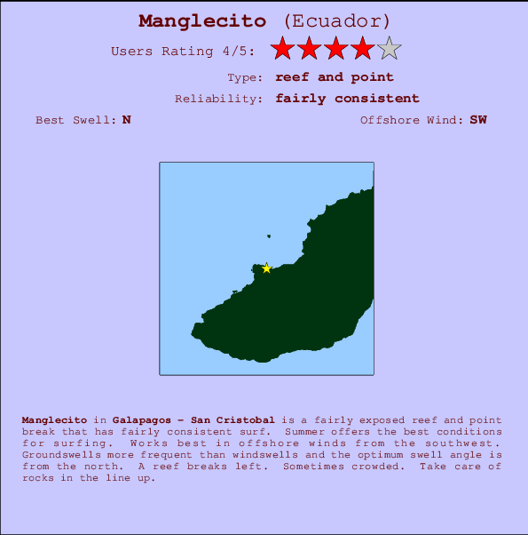
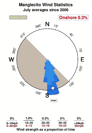
Manglecito in Galapagos - San Cristobal is a quite exposed reef and point break that has quite consistent surf. Summer offers the optimum conditions for surfing. Works best in offshore winds from the southwest. Groundswells more frequent than windswells and the ideal swell angle is from the north. A left hand reef. When the surf is up, it can get quite busy in the water. Rocks are a hazard.
Manglecito Spot Info
| Type: | Rating: | Reliability: | Todays Sea Temp*: |
|---|---|---|---|
| fairly consistent | 26.2°C*ocean temperature recorded from satellite |
Surfing Manglecito:
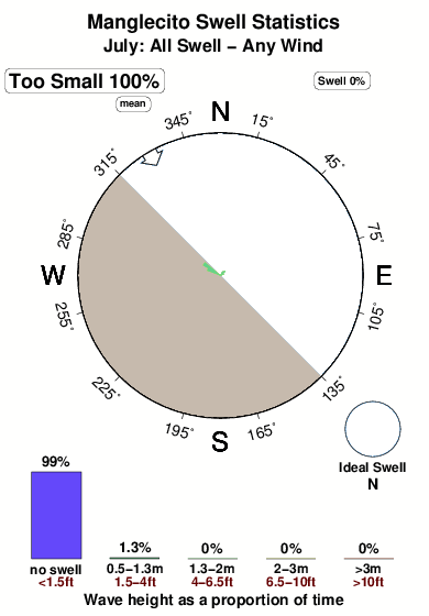
The best conditions reported for surf at Manglecito occur when a North swell combines with an offshore wind direction from the Southwest.

Voorspelde Golfenergie (Kracht): 12 uur

Manglecito Surf:
Saturday, 18 July 2026, 20:12 Local time| Sat | Sunday 19 | |||
| 9PM | 0AM | 3AM | 6AM | |
| Wave (m) | ||||
| Periode (s) | 10 | 10 | 10 | 9 |
| Wind (km/h) | ||||
| Wind | cross- off |
cross- off |
cross- off |
cross- off |
- /breaks/Manglecito/forecasts/latest
Manglecito Surf Guide
Manglecito in Galapagos - San Cristobal is a quite exposed reef and point break that has quite consistent surf. Summer offers the optimum conditions for surfing. Works best in offshore winds from the southwest. Groundswells more frequent than windswells and the ideal swell angle is from the north. A left hand reef. When the surf is up, it can get quite busy in the water. Rocks are a hazard.
Manglecito Spot Info
Type: Rating: Reliability: Todays Sea Temp*:  Reef and point
 4
4fairly consistent 26.2°C*ocean temperature recorded from satelliteSurfing Manglecito:
The best conditions reported for surf at Manglecito occur when a North swell combines with an offshore wind direction from the Southwest.
Voorspelde Golfenergie (Kracht): 12 uur
Gebruik de tabbladen hierboven om de zeewatertemperatuur bij Manglecito te bekijken, foto's van Manglecito, Manglecito gedetailleerde golfvoorspellingen, wind- en weersvoorspellingen, Manglecito webcams, actuele wind in Galapagos - San Cristobal live weerstations en Manglecito getijdenvoorspellingen. De link van Ecuador golfkaarten opent een grote afbeelding van Ecuador en de omliggende zeeën. Deze golfkaarten kunnen worden dynamisch gemaakt worden met de verschillende golfcomponenten, golfenergie, golfperiode, golfhoogte, samen met de wind en weersvoorspellingen, het actuele weer en de zeetoestand volgens golfboeien uit Ecuador, langskomende schepen en weerstations op de kust. Elk voorspelling pagina's voor dit surfstrand zijn voorzien van een wereldwijde en regionale golfzoeker om de beste surfsomstandigheden in het gebied rond Manglecito te vinden.
Manglecito Surf:
Saturday, 18 July 2026, 20:12 Local timeSat Sunday 19 9PM 0AM 3AM 6AM Wave (m) Periode (s) 10 10 10 9 Wind (km/h) Wind cross-
offcross-
offcross-
offcross-
off- /breaks/Manglecito/forecasts/latest
- /breaks/Manglecito/forecasts/latest/six_day
Manglecito Surf Guide
Manglecito in Galapagos - San Cristobal is a quite exposed reef and point break that has quite consistent surf. Summer offers the optimum conditions for surfing. Works best in offshore winds from the southwest. Groundswells more frequent than windswells and the ideal swell angle is from the north. A left hand reef. When the surf is up, it can get quite busy in the water. Rocks are a hazard.
Manglecito Spot Info
Type: Rating: Reliability: Todays Sea Temp*: Reef and point4fairly consistent 26.2°C*ocean temperature recorded from satelliteSurfing Manglecito:
The best conditions reported for surf at Manglecito occur when a North swell combines with an offshore wind direction from the Southwest.
Voorspelde Golfenergie (Kracht): 12 uur
Gebruik de tabbladen hierboven om de zeewatertemperatuur bij Manglecito te bekijken, foto's van Manglecito, Manglecito gedetailleerde golfvoorspellingen, wind- en weersvoorspellingen, Manglecito webcams, actuele wind in Galapagos - San Cristobal live weerstations en Manglecito getijdenvoorspellingen. De link van Ecuador golfkaarten opent een grote afbeelding van Ecuador en de omliggende zeeën. Deze golfkaarten kunnen worden dynamisch gemaakt worden met de verschillende golfcomponenten, golfenergie, golfperiode, golfhoogte, samen met de wind en weersvoorspellingen, het actuele weer en de zeetoestand volgens golfboeien uit Ecuador, langskomende schepen en weerstations op de kust. Elk voorspelling pagina's voor dit surfstrand zijn voorzien van een wereldwijde en regionale golfzoeker om de beste surfsomstandigheden in het gebied rond Manglecito te vinden.
Manglecito Surf:
Saturday, 18 July 2026, 20:12 Local timeSat Sunday 19 9PM 0AM 3AM 6AM Wave (m) Periode (s) 10 10 10 9 Wind (km/h) Wind cross-
offcross-
offcross-
offcross-
off- /breaks/Manglecito/forecasts/latest
Manglecito Surf Guide
Manglecito in Galapagos - San Cristobal is a quite exposed reef and point break that has quite consistent surf. Summer offers the optimum conditions for surfing. Works best in offshore winds from the southwest. Groundswells more frequent than windswells and the ideal swell angle is from the north. A left hand reef. When the surf is up, it can get quite busy in the water. Rocks are a hazard.
Manglecito Spot Info
Type: Rating: Reliability: Todays Sea Temp*: Reef and point4fairly consistent 26.2°C*ocean temperature recorded from satelliteSurfing Manglecito:
The best conditions reported for surf at Manglecito occur when a North swell combines with an offshore wind direction from the Southwest.
Voorspelde Golfenergie (Kracht): 12 uur
Gebruik de tabbladen hierboven om de zeewatertemperatuur bij Manglecito te bekijken, foto's van Manglecito, Manglecito gedetailleerde golfvoorspellingen, wind- en weersvoorspellingen, Manglecito webcams, actuele wind in Galapagos - San Cristobal live weerstations en Manglecito getijdenvoorspellingen. De link van Ecuador golfkaarten opent een grote afbeelding van Ecuador en de omliggende zeeën. Deze golfkaarten kunnen worden dynamisch gemaakt worden met de verschillende golfcomponenten, golfenergie, golfperiode, golfhoogte, samen met de wind en weersvoorspellingen, het actuele weer en de zeetoestand volgens golfboeien uit Ecuador, langskomende schepen en weerstations op de kust. Elk voorspelling pagina's voor dit surfstrand zijn voorzien van een wereldwijde en regionale golfzoeker om de beste surfsomstandigheden in het gebied rond Manglecito te vinden.
Manglecito Surf:
Saturday, 18 July 2026, 20:12 Local timeSat Sunday 19 9PM 0AM 3AM 6AM Wave (m) Periode (s) 10 10 10 9 Wind (km/h) Wind cross-
offcross-
offcross-
offcross-
offTide Times:
Op Manglecito (0 km).
VOLGENDE IS OM (lokale tijd) resterende tijd hoog water laag water Manglecito Tide Times and Tide Chart
Live Weather:
At Puerto Ayora, 88 km from Manglecito.
light winds from the WSW
(km/h)
dryAir temperature
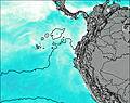
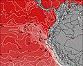
26°COverall Manglecito Surf Consistency and Wind Distribution in July
surffoto's uit
de galerijContourlijnen: Wegen & Rivieren: Kies een surflokatie uit het menu 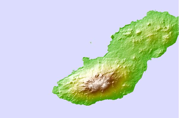
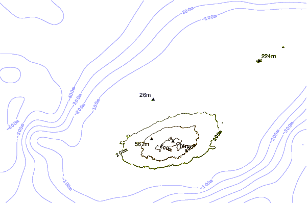
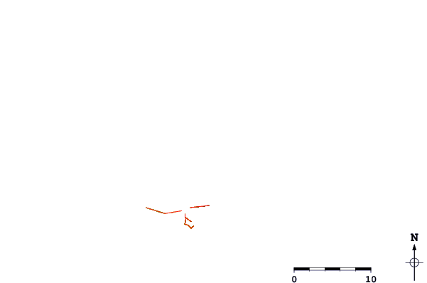
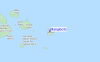
Gebruik deze reliëfkaart om naar de surfspots en de getijdenstations van Galapagos - San Cristobal toe te gaan, in de buurt van Manglecito.
Andere Dichtbijzijnde Surflocaties van Manglecito:
(klik op locatienaam voor meer informatie)- Closest Locatie8 mi
- Second closest Locatie9 mi
- Third closest Locatie9 mi
- Fourth closest Locatie10 mi
- Fifth closest Locatie21 mi
Dichtstbijzijnde golfboeien bij Manglecito:
- Closest golfboei1321 mi
- Second closest golfboei1337 mi
- Third closest golfboei1462 mi
- Fourth closest golfboei1608 mi
- Fifth closest golfboei1847 mi
Getijdenstations in de buurt van Manglecito:
- Closest getijdenstationSan Cristobal9 mi
- Second closest getijdenstationPuerto Ayora55 mi
- Third closest getijdenstationIsla Baltra58 mi
- Fourth closest getijdenstationSalinas599 mi
- Fifth closest getijdenstationLa Libertad602 mi
Airports
- The nearest passenger airport to Manglecito is Seymour (Galapagos) Airport (GPS) in Galapagos I. (ecuador, which is 92 km (57 miles) away (directly).
- The second closest airport to Manglecito is General Ulpiano Paez (Salinas) Airport (SNC) in Ecuador, 961 km (597 miles) away.
- /breaks/Manglecito/forecasts/latest


 Nearest