
Masa Chapa Surf Guide
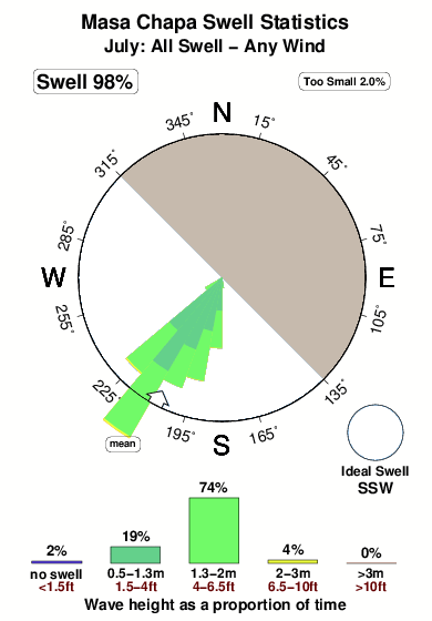
Masa Chapa in Leon Province is an exposed reef break that only works once in a while Offshore winds are from the northeast. Easily blown out by an onshore breeze Groundswells more frequent than windswells and the ideal swell direction is from the south southwest. A right hand reef break. Best around low tide. Unlikely to be too crowded, even when the surf is up. Hazards include rips and rocks.
Masa Chapa Spot Info
| Type: | Rating: | Reliability: | Todays Sea Temp*: |
|---|---|---|---|
| inconsistent | 29.1°C*ocean temperature recorded from satellite |
Surfing Masa Chapa:
The best conditions reported for surf at Masa Chapa occur when a South-southwest swell combines with an offshore wind direction from the Northeast.

Voorspelde Golfenergie (Kracht): 12 uur


Masa Chapa Surf:
Tuesday, 21 July 2026, 01:51 Local time| Mon | Tuesday 21 | |||
| 9PM | 0AM | 3AM | 6AM | |
| Wave (m) | ||||
| Periode (s) | 16 | 16 | 15 | 15 |
| Wind (km/h) | ||||
| Wind | cross- off |
cross- off |
off | off |
- /breaks/Masa-Chapa/forecasts/latest
Masa Chapa Surf Guide
Masa Chapa in Leon Province is an exposed reef break that only works once in a while Offshore winds are from the northeast. Easily blown out by an onshore breeze Groundswells more frequent than windswells and the ideal swell direction is from the south southwest. A right hand reef break. Best around low tide. Unlikely to be too crowded, even when the surf is up. Hazards include rips and rocks.
Masa Chapa Spot Info
Type: Rating: Reliability: Todays Sea Temp*:  Reef
Reef 3
3inconsistent 29.1°C*ocean temperature recorded from satelliteSurfing Masa Chapa:
The best conditions reported for surf at Masa Chapa occur when a South-southwest swell combines with an offshore wind direction from the Northeast.
Voorspelde Golfenergie (Kracht): 12 uur
Gebruik de tabbladen hierboven om de zeewatertemperatuur bij Masa Chapa te bekijken, foto's van Masa Chapa, Masa Chapa gedetailleerde golfvoorspellingen, wind- en weersvoorspellingen, Masa Chapa webcams, actuele wind in Leon Province live weerstations en Masa Chapa getijdenvoorspellingen. De link van Nicaragua golfkaarten opent een grote afbeelding van Nicaragua en de omliggende zeeën. Deze golfkaarten kunnen worden dynamisch gemaakt worden met de verschillende golfcomponenten, golfenergie, golfperiode, golfhoogte, samen met de wind en weersvoorspellingen, het actuele weer en de zeetoestand volgens golfboeien uit Nicaragua, langskomende schepen en weerstations op de kust. Elk voorspelling pagina's voor dit surfstrand zijn voorzien van een wereldwijde en regionale golfzoeker om de beste surfsomstandigheden in het gebied rond Masa Chapa te vinden.
Masa Chapa Surf:
Tuesday, 21 July 2026, 01:51 Local timeMon Tuesday 21 9PM 0AM 3AM 6AM Wave (m) Periode (s) 16 16 15 15 Wind (km/h) Wind cross-
offcross-
offoff off - /breaks/Masa-Chapa/forecasts/latest
- /breaks/Masa-Chapa/forecasts/latest/six_day
Masa Chapa Surf Guide
Masa Chapa in Leon Province is an exposed reef break that only works once in a while Offshore winds are from the northeast. Easily blown out by an onshore breeze Groundswells more frequent than windswells and the ideal swell direction is from the south southwest. A right hand reef break. Best around low tide. Unlikely to be too crowded, even when the surf is up. Hazards include rips and rocks.
Masa Chapa Spot Info
Type: Rating: Reliability: Todays Sea Temp*: Reef3inconsistent 29.1°C*ocean temperature recorded from satelliteSurfing Masa Chapa:
The best conditions reported for surf at Masa Chapa occur when a South-southwest swell combines with an offshore wind direction from the Northeast.
Voorspelde Golfenergie (Kracht): 12 uur
Gebruik de tabbladen hierboven om de zeewatertemperatuur bij Masa Chapa te bekijken, foto's van Masa Chapa, Masa Chapa gedetailleerde golfvoorspellingen, wind- en weersvoorspellingen, Masa Chapa webcams, actuele wind in Leon Province live weerstations en Masa Chapa getijdenvoorspellingen. De link van Nicaragua golfkaarten opent een grote afbeelding van Nicaragua en de omliggende zeeën. Deze golfkaarten kunnen worden dynamisch gemaakt worden met de verschillende golfcomponenten, golfenergie, golfperiode, golfhoogte, samen met de wind en weersvoorspellingen, het actuele weer en de zeetoestand volgens golfboeien uit Nicaragua, langskomende schepen en weerstations op de kust. Elk voorspelling pagina's voor dit surfstrand zijn voorzien van een wereldwijde en regionale golfzoeker om de beste surfsomstandigheden in het gebied rond Masa Chapa te vinden.
Masa Chapa Surf:
Tuesday, 21 July 2026, 01:51 Local timeMon Tuesday 21 9PM 0AM 3AM 6AM Wave (m) Periode (s) 16 16 15 15 Wind (km/h) Wind cross-
offcross-
offoff off - /breaks/Masa-Chapa/forecasts/latest
Masa Chapa Surf Guide
Masa Chapa in Leon Province is an exposed reef break that only works once in a while Offshore winds are from the northeast. Easily blown out by an onshore breeze Groundswells more frequent than windswells and the ideal swell direction is from the south southwest. A right hand reef break. Best around low tide. Unlikely to be too crowded, even when the surf is up. Hazards include rips and rocks.
Masa Chapa Spot Info
Type: Rating: Reliability: Todays Sea Temp*: Reef3inconsistent 29.1°C*ocean temperature recorded from satelliteSurfing Masa Chapa:
The best conditions reported for surf at Masa Chapa occur when a South-southwest swell combines with an offshore wind direction from the Northeast.
Voorspelde Golfenergie (Kracht): 12 uur
Gebruik de tabbladen hierboven om de zeewatertemperatuur bij Masa Chapa te bekijken, foto's van Masa Chapa, Masa Chapa gedetailleerde golfvoorspellingen, wind- en weersvoorspellingen, Masa Chapa webcams, actuele wind in Leon Province live weerstations en Masa Chapa getijdenvoorspellingen. De link van Nicaragua golfkaarten opent een grote afbeelding van Nicaragua en de omliggende zeeën. Deze golfkaarten kunnen worden dynamisch gemaakt worden met de verschillende golfcomponenten, golfenergie, golfperiode, golfhoogte, samen met de wind en weersvoorspellingen, het actuele weer en de zeetoestand volgens golfboeien uit Nicaragua, langskomende schepen en weerstations op de kust. Elk voorspelling pagina's voor dit surfstrand zijn voorzien van een wereldwijde en regionale golfzoeker om de beste surfsomstandigheden in het gebied rond Masa Chapa te vinden.
Masa Chapa Surf:
Tuesday, 21 July 2026, 01:51 Local timeMon Tuesday 21 9PM 0AM 3AM 6AM Wave (m) Periode (s) 16 16 15 15 Wind (km/h) Wind cross-
offcross-
offoff off Tide Times:
Voor Masachapa, %{dist} %{km} van %{location}.
VOLGENDE IS OM (lokale tijd) resterende tijd hoog water laag water Masa Chapa Tide Times and Tide Chart
Live Weather:
At Managua/Augusto Cesar Sandino International Airport, 56 km from Masa Chapa.
light winds from the ESE
(km/h)Air temperature
26°COverall Masa Chapa Surf Consistency and Wind Distribution in July
surffoto's uit
de galerijContourlijnen: Wegen & Rivieren: Kies een surflokatie uit het menu 


Gebruik deze reliëfkaart om naar de surfspots en de getijdenstations van Leon Province toe te gaan, in de buurt van Masa Chapa.
Andere Dichtbijzijnde Surflocaties van Masa Chapa:
(klik op locatienaam voor meer informatie)- Closest Locatie1 mi
- Second closest Locatie1 mi
- Third closest Locatie2 mi
- Fourth closest Locatie6 mi
- Fifth closest Locatie9 mi
Dichtstbijzijnde golfboeien bij Masa Chapa:
- Closest golfboei485 mi
- Second closest golfboei568 mi
- Third closest golfboei865 mi
- Fourth closest golfboei981 mi
- Fifth closest golfboei983 mi
Getijdenstations in de buurt van Masa Chapa:
- Closest getijdenstationMasachapa1 mi
- Second closest getijdenstationSan Juan del Sur57 mi
- Third closest getijdenstationCorinto66 mi
- Fourth closest getijdenstationEl Realejo68 mi
- Fifth closest getijdenstationLa Union, El Salvador139 mi
Airports
- The nearest passenger airport to Masa Chapa is Managua International Airport (MGA) in Nicaragua, which is 56 km (35 miles) away (directly).
- The second closest airport to Masa Chapa is Daniel Oduber Quiros International (Liberia) Airport (LIR) in Costa Rica, 169 km (105 miles) away.

- /breaks/Masa-Chapa/forecasts/latest


 Nearest