

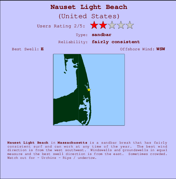
Nauset Light Beach Surf Guide
Nauset Light Beach in Massachusetts is an exposed sandbar break that has quite reliable surf and can work at any time of the year. Works best in offshore winds from the west southwest. Most of the surf here comes from groundswells and the best swell direction is from the east. When the surf is up, it can get quite busy in the water. Take care of - Urchins - Rips / undertow.
Nauset Light Beach Spot Info
| Type: | Rating: | Reliability: | Todays Sea Temp*: |
|---|---|---|---|
| fairly consistent | 19.0°C*ocean temperature recorded from satellite |
Surfing Nauset Light Beach:
The best conditions reported for surf at Nauset Light Beach occur when a East swell combines with an offshore wind direction from the West-southwest.

Voorspelde Golfenergie (Kracht): 12 uur


Nauset Light Beach Surf:
Thursday, 16 July 2026, 12:51 Local time| Thursday 16 | ||||
| 11AM | 2PM | 5PM | 8PM | |
| Wave (m) | ||||
| Periode (s) | 6 | 15 | 15 | 15 |
| Wind (km/h) | ||||
| Wind | off | cross- off |
cross- off |
cross |
- /breaks/Nauset-Light-Beach-1/forecasts/latest
Nauset Light Beach Surf Guide
Nauset Light Beach in Massachusetts is an exposed sandbar break that has quite reliable surf and can work at any time of the year. Works best in offshore winds from the west southwest. Most of the surf here comes from groundswells and the best swell direction is from the east. When the surf is up, it can get quite busy in the water. Take care of - Urchins - Rips / undertow.
Nauset Light Beach Spot Info
Type: Rating: Reliability: Todays Sea Temp*:  Sandbar
 2
2fairly consistent 19.0°C*ocean temperature recorded from satelliteSurfing Nauset Light Beach:
The best conditions reported for surf at Nauset Light Beach occur when a East swell combines with an offshore wind direction from the West-southwest.
Voorspelde Golfenergie (Kracht): 12 uur
Gebruik de tabbladen hierboven om de zeewatertemperatuur bij Nauset Light Beach te bekijken, foto's van Nauset Light Beach, Nauset Light Beach gedetailleerde golfvoorspellingen, wind- en weersvoorspellingen, Nauset Light Beach webcams, actuele wind in Massachusetts live weerstations en Nauset Light Beach getijdenvoorspellingen. De link van United States golfkaarten opent een grote afbeelding van United States en de omliggende zeeën. Deze golfkaarten kunnen worden dynamisch gemaakt worden met de verschillende golfcomponenten, golfenergie, golfperiode, golfhoogte, samen met de wind en weersvoorspellingen, het actuele weer en de zeetoestand volgens golfboeien uit United States, langskomende schepen en weerstations op de kust. Elk voorspelling pagina's voor dit surfstrand zijn voorzien van een wereldwijde en regionale golfzoeker om de beste surfsomstandigheden in het gebied rond Nauset Light Beach te vinden.
Nauset Light Beach Surf:
Thursday, 16 July 2026, 12:51 Local timeThursday 16 11AM 2PM 5PM 8PM Wave (m) Periode (s) 6 15 15 15 Wind (km/h) Wind off cross-
offcross-
offcross - /breaks/Nauset-Light-Beach-1/forecasts/latest
- /breaks/Nauset-Light-Beach-1/forecasts/latest/six_day
Nauset Light Beach Surf Guide
Nauset Light Beach in Massachusetts is an exposed sandbar break that has quite reliable surf and can work at any time of the year. Works best in offshore winds from the west southwest. Most of the surf here comes from groundswells and the best swell direction is from the east. When the surf is up, it can get quite busy in the water. Take care of - Urchins - Rips / undertow.
Nauset Light Beach Spot Info
Type: Rating: Reliability: Todays Sea Temp*: Sandbar2fairly consistent 19.0°C*ocean temperature recorded from satelliteSurfing Nauset Light Beach:
The best conditions reported for surf at Nauset Light Beach occur when a East swell combines with an offshore wind direction from the West-southwest.
Voorspelde Golfenergie (Kracht): 12 uur
Gebruik de tabbladen hierboven om de zeewatertemperatuur bij Nauset Light Beach te bekijken, foto's van Nauset Light Beach, Nauset Light Beach gedetailleerde golfvoorspellingen, wind- en weersvoorspellingen, Nauset Light Beach webcams, actuele wind in Massachusetts live weerstations en Nauset Light Beach getijdenvoorspellingen. De link van United States golfkaarten opent een grote afbeelding van United States en de omliggende zeeën. Deze golfkaarten kunnen worden dynamisch gemaakt worden met de verschillende golfcomponenten, golfenergie, golfperiode, golfhoogte, samen met de wind en weersvoorspellingen, het actuele weer en de zeetoestand volgens golfboeien uit United States, langskomende schepen en weerstations op de kust. Elk voorspelling pagina's voor dit surfstrand zijn voorzien van een wereldwijde en regionale golfzoeker om de beste surfsomstandigheden in het gebied rond Nauset Light Beach te vinden.
Nauset Light Beach Surf:
Thursday, 16 July 2026, 12:51 Local timeThursday 16 11AM 2PM 5PM 8PM Wave (m) Periode (s) 6 15 15 15 Wind (km/h) Wind off cross-
offcross-
offcross - /breaks/Nauset-Light-Beach-1/forecasts/latest
Nauset Light Beach Surf Guide
Nauset Light Beach in Massachusetts is an exposed sandbar break that has quite reliable surf and can work at any time of the year. Works best in offshore winds from the west southwest. Most of the surf here comes from groundswells and the best swell direction is from the east. When the surf is up, it can get quite busy in the water. Take care of - Urchins - Rips / undertow.
Nauset Light Beach Spot Info
Type: Rating: Reliability: Todays Sea Temp*: Sandbar2fairly consistent 19.0°C*ocean temperature recorded from satelliteSurfing Nauset Light Beach:
The best conditions reported for surf at Nauset Light Beach occur when a East swell combines with an offshore wind direction from the West-southwest.
Voorspelde Golfenergie (Kracht): 12 uur
Gebruik de tabbladen hierboven om de zeewatertemperatuur bij Nauset Light Beach te bekijken, foto's van Nauset Light Beach, Nauset Light Beach gedetailleerde golfvoorspellingen, wind- en weersvoorspellingen, Nauset Light Beach webcams, actuele wind in Massachusetts live weerstations en Nauset Light Beach getijdenvoorspellingen. De link van United States golfkaarten opent een grote afbeelding van United States en de omliggende zeeën. Deze golfkaarten kunnen worden dynamisch gemaakt worden met de verschillende golfcomponenten, golfenergie, golfperiode, golfhoogte, samen met de wind en weersvoorspellingen, het actuele weer en de zeetoestand volgens golfboeien uit United States, langskomende schepen en weerstations op de kust. Elk voorspelling pagina's voor dit surfstrand zijn voorzien van een wereldwijde en regionale golfzoeker om de beste surfsomstandigheden in het gebied rond Nauset Light Beach te vinden.
Nauset Light Beach Surf:
Thursday, 16 July 2026, 12:51 Local timeThursday 16 11AM 2PM 5PM 8PM Wave (m) Periode (s) 6 15 15 15 Wind (km/h) Wind off cross-
offcross-
offcross Tide Times:
Voor Nauset Harbor, Massachusetts, %{dist} %{km} van %{location}.
VOLGENDE IS OM (lokale tijd) resterende tijd hoog water laag water Nauset Light Beach Tide Times and Tide Chart
Live Weather:
At Chatham Airport, 14 km from Nauset Light Beach.
light winds from the SW
(km/h)
ClearAir temperature
25.6°CCurrent weather near Nauset Light Beach
Buoy Data:
At Cape Cod Bay, MA, 20 miles from Nauset Light Beach.
7AM 8AM 9AM 10AM Gegevens Leeftijd 4 hr 3 hr 2 hr 1 hr Golfhoogte (m) 


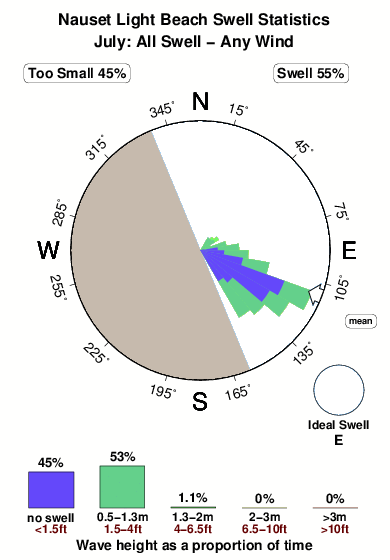
Dominante Periode (s) 4 3 3 - Overall Nauset Light Beach Surf Consistency and Wind Distribution in July
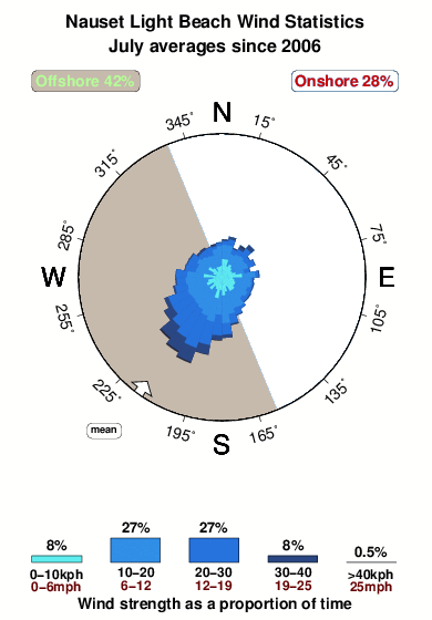


Wind stats for Nauset Light Beach: see the variation in direction and stength by month.
surffoto's uit
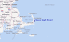
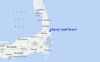
de galerijContourlijnen: Wegen & Rivieren: Kies een surflokatie uit het menu 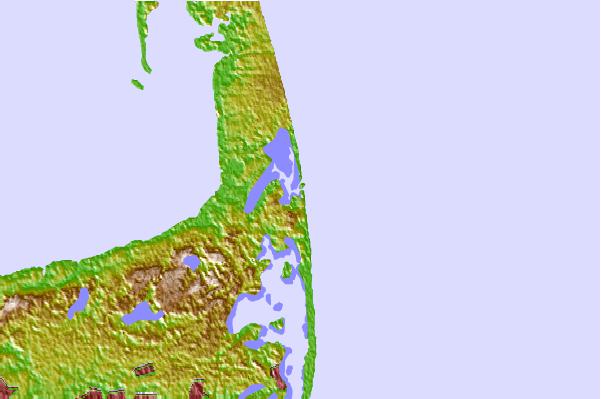
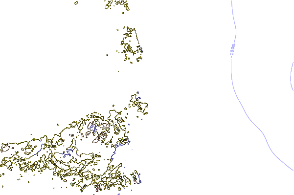
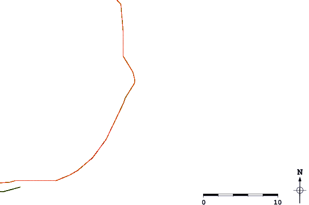
Gebruik deze reliëfkaart om naar de surfspots en de getijdenstations van Massachusetts toe te gaan, in de buurt van Nauset Light Beach.
Andere Dichtbijzijnde Surflocaties van Nauset Light Beach:
(klik op locatienaam voor meer informatie)- Closest Locatie1 mi
- Second closest Locatie2 mi
- Third closest Locatie7 mi
- Fourth closest Locatie9 mi
- Fifth closest Locatie9 mi
Dichtstbijzijnde golfboeien bij Nauset Light Beach:
- Closest golfboei20 mi
- Second closest golfboei28 mi
- Third closest golfboei50 mi
- Fourth closest golfboei53 mi
- Fifth closest golfboei59 mi
Getijdenstations in de buurt van Nauset Light Beach:
- Closest getijdenstationNauset Harbor1 mi
- Second closest getijdenstationEastham2 mi
- Third closest getijdenstationPleasant Bay, Cape Cod5 mi
- Fourth closest getijdenstationPleasant Bay5 mi
- Fifth closest getijdenstationChatham, Cape Cod7 mi
Airports
- The closest passenger airport to Nauset Light Beach is Otis Angb (Falmouth) Airport (FMH) in USA, 51 km (32 miles) away (directly).
- The second nearest airport to Nauset Light Beach is Nantucket Mem Airport (ACK), also in USA, 62 km (39 miles) away.
- Third is General Edward Lawrence Logan International (Boston) Airport (BOS) in USA, 108 km (67 miles) away.
- Theodore Francis Green State (Providence) Airport (PVD) in USA is 124 km (77 miles) away.
- North Central State (Smithfield) Airport (SFZ), also in USA is the fifth nearest airport to Nauset Light Beach and is 129 km (80 miles) away.
- /breaks/Nauset-Light-Beach-1/forecasts/latest


 Nearest