
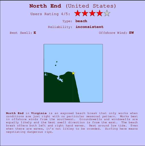
North End Surf Guide
North End in Virginia is an exposed beach break that has inconsistent surf with no particular seasonal pattern. Offshore winds are from the southwest. Most of the surf here comes from groundswells and the ideal swell direction is from the east. The beach break provides left and right handers. Best around low tide. Even when there are waves, it's not likley to be crowded. Surfing here means negotiating dangerous rips.
North End Spot Info
| Type: | Rating: | Reliability: | Todays Sea Temp*: |
|---|---|---|---|
| inconsistent | 26.8°C*ocean temperature recorded from satellite |
Surfing North End:
The best conditions reported for surf at North End occur when a East swell combines with an offshore wind direction from the Southwest.

Voorspelde Golfenergie (Kracht): 12 uur
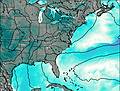

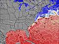
North End Surf:
Sunday, 19 July 2026, 23:23 Local time| Sun | Monday 20 | |||
| 11PM | 2AM | 5AM | 8AM | |
| Wave (m) | ||||
| Periode (s) | 8 | 8 | 8 | 8 |
| Wind (km/h) | ||||
| Wind | cross- off |
glass | cross- on |
cross- on |
- /breaks/North-End/forecasts/latest
North End Surf Guide
North End in Virginia is an exposed beach break that has inconsistent surf with no particular seasonal pattern. Offshore winds are from the southwest. Most of the surf here comes from groundswells and the ideal swell direction is from the east. The beach break provides left and right handers. Best around low tide. Even when there are waves, it's not likley to be crowded. Surfing here means negotiating dangerous rips.
North End Spot Info
Type: Rating: Reliability: Todays Sea Temp*:  Beach
Beach 4
4inconsistent 26.8°C*ocean temperature recorded from satelliteSurfing North End:
The best conditions reported for surf at North End occur when a East swell combines with an offshore wind direction from the Southwest.
Voorspelde Golfenergie (Kracht): 12 uur
Gebruik de tabbladen hierboven om de zeewatertemperatuur bij North End te bekijken, foto's van North End, North End gedetailleerde golfvoorspellingen, wind- en weersvoorspellingen, North End webcams, actuele wind in Virginia live weerstations en North End getijdenvoorspellingen. De link van United States golfkaarten opent een grote afbeelding van United States en de omliggende zeeën. Deze golfkaarten kunnen worden dynamisch gemaakt worden met de verschillende golfcomponenten, golfenergie, golfperiode, golfhoogte, samen met de wind en weersvoorspellingen, het actuele weer en de zeetoestand volgens golfboeien uit United States, langskomende schepen en weerstations op de kust. Elk voorspelling pagina's voor dit surfstrand zijn voorzien van een wereldwijde en regionale golfzoeker om de beste surfsomstandigheden in het gebied rond North End te vinden.
North End Surf:
Sunday, 19 July 2026, 23:23 Local timeSun Monday 20 11PM 2AM 5AM 8AM Wave (m) Periode (s) 8 8 8 8 Wind (km/h) Wind cross-
offglass cross-
oncross-
on- /breaks/North-End/forecasts/latest
- /breaks/North-End/forecasts/latest/six_day
North End Surf Guide
North End in Virginia is an exposed beach break that has inconsistent surf with no particular seasonal pattern. Offshore winds are from the southwest. Most of the surf here comes from groundswells and the ideal swell direction is from the east. The beach break provides left and right handers. Best around low tide. Even when there are waves, it's not likley to be crowded. Surfing here means negotiating dangerous rips.
North End Spot Info
Type: Rating: Reliability: Todays Sea Temp*: Beach4inconsistent 26.8°C*ocean temperature recorded from satelliteSurfing North End:
The best conditions reported for surf at North End occur when a East swell combines with an offshore wind direction from the Southwest.
Voorspelde Golfenergie (Kracht): 12 uur
Gebruik de tabbladen hierboven om de zeewatertemperatuur bij North End te bekijken, foto's van North End, North End gedetailleerde golfvoorspellingen, wind- en weersvoorspellingen, North End webcams, actuele wind in Virginia live weerstations en North End getijdenvoorspellingen. De link van United States golfkaarten opent een grote afbeelding van United States en de omliggende zeeën. Deze golfkaarten kunnen worden dynamisch gemaakt worden met de verschillende golfcomponenten, golfenergie, golfperiode, golfhoogte, samen met de wind en weersvoorspellingen, het actuele weer en de zeetoestand volgens golfboeien uit United States, langskomende schepen en weerstations op de kust. Elk voorspelling pagina's voor dit surfstrand zijn voorzien van een wereldwijde en regionale golfzoeker om de beste surfsomstandigheden in het gebied rond North End te vinden.
North End Surf:
Sunday, 19 July 2026, 23:23 Local timeSun Monday 20 11PM 2AM 5AM 8AM Wave (m) Periode (s) 8 8 8 8 Wind (km/h) Wind cross-
offglass cross-
oncross-
on- /breaks/North-End/forecasts/latest
North End Surf Guide
North End in Virginia is an exposed beach break that has inconsistent surf with no particular seasonal pattern. Offshore winds are from the southwest. Most of the surf here comes from groundswells and the ideal swell direction is from the east. The beach break provides left and right handers. Best around low tide. Even when there are waves, it's not likley to be crowded. Surfing here means negotiating dangerous rips.
North End Spot Info
Type: Rating: Reliability: Todays Sea Temp*: Beach4inconsistent 26.8°C*ocean temperature recorded from satelliteSurfing North End:
The best conditions reported for surf at North End occur when a East swell combines with an offshore wind direction from the Southwest.
Voorspelde Golfenergie (Kracht): 12 uur
Gebruik de tabbladen hierboven om de zeewatertemperatuur bij North End te bekijken, foto's van North End, North End gedetailleerde golfvoorspellingen, wind- en weersvoorspellingen, North End webcams, actuele wind in Virginia live weerstations en North End getijdenvoorspellingen. De link van United States golfkaarten opent een grote afbeelding van United States en de omliggende zeeën. Deze golfkaarten kunnen worden dynamisch gemaakt worden met de verschillende golfcomponenten, golfenergie, golfperiode, golfhoogte, samen met de wind en weersvoorspellingen, het actuele weer en de zeetoestand volgens golfboeien uit United States, langskomende schepen en weerstations op de kust. Elk voorspelling pagina's voor dit surfstrand zijn voorzien van een wereldwijde en regionale golfzoeker om de beste surfsomstandigheden in het gebied rond North End te vinden.
North End Surf:
Sunday, 19 July 2026, 23:23 Local timeSun Monday 20 11PM 2AM 5AM 8AM Wave (m) Periode (s) 8 8 8 8 Wind (km/h) Wind cross-
offglass cross-
oncross-
onTide Times:
Voor Cape Henry, Chesapeake Bay, Virginia, %{dist} %{km} van %{location}.
VOLGENDE IS OM (lokale tijd) resterende tijd hoog water laag water North End Tide Times and Tide Chart
Live Weather:
At BUOY-CHYV2, 1 km from North End.
light winds from the ENE
(km/h)Air temperature
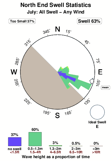
24.9°COverall North End Surf Consistency and Wind Distribution in July
surffoto's uit
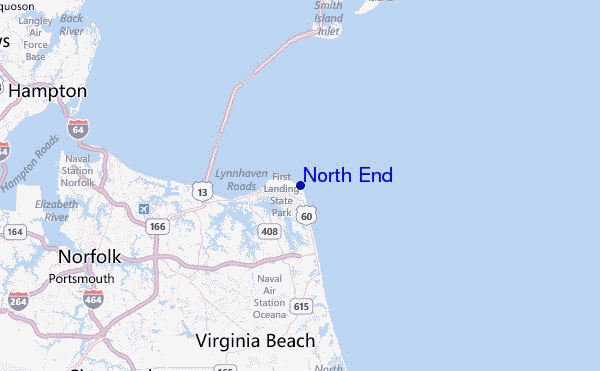
de galerijContourlijnen: Wegen & Rivieren: Kies een surflokatie uit het menu 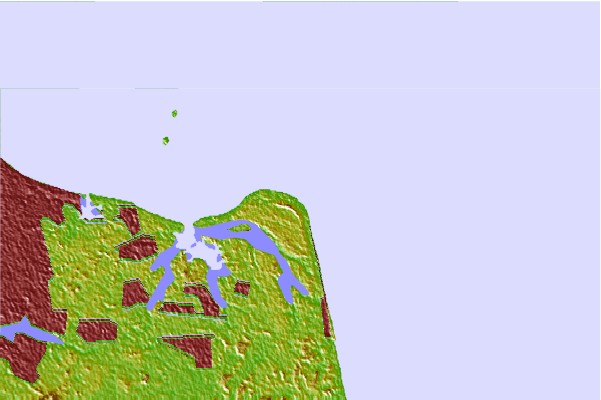

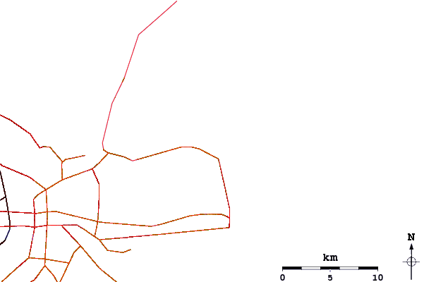
Gebruik deze reliëfkaart om naar de surfspots en de getijdenstations van Virginia toe te gaan, in de buurt van North End.
Andere Dichtbijzijnde Surflocaties van North End:
(klik op locatienaam voor meer informatie)- Closest Locatie1 mi
- Second closest Locatie4 mi
- Third closest Locatie7 mi
- Fourth closest Locatie9 mi
- Fifth closest Locatie10 mi
Dichtstbijzijnde golfboeien bij North End:
- Closest golfboei7 mi
- Second closest golfboei11 mi
- Third closest golfboei12 mi
- Fourth closest golfboei16 mi
- Fifth closest golfboei24 mi
Getijdenstations in de buurt van North End:
- Closest getijdenstationCape Henry, Chesapeake Bay1 mi
- Second closest getijdenstationBroad Bay Canal, Lynnhaven Bay4 mi
- Third closest getijdenstationLong Creek, Chesapeake Bay4 mi
- Fourth closest getijdenstationHighway bridge, east of, Chesapeake Bay5 mi
- Fifth closest getijdenstationVirginia pilot's dock, Lynnhaven Inlet, Chesapeake Bay5 mi
Airports
- The closest passenger airport to North End is Oceana Nas Airport (NTU) in USA, 12 km (7 miles) away (directly).
- The second nearest airport to North End is Norfolk International Airport (ORF), also in USA, 18 km (11 miles) away.
- Third is Norfolk Ns Airport (NGU) in USA, 26 km (16 miles) away.
- Langley Afb (Hampton) Airport (LFI) in USA is 37 km (23 miles) away.
- Newport News Williamsburg International Airport (PHF), also in USA is the fifth nearest airport to North End and is 50 km (31 miles) away.
- /breaks/North-End/forecasts/latest


 Nearest