

Out Front Surf Guide
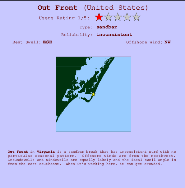
Out Front in Virginia is an exposed sandbar break that has inconsistent surf with no particular seasonal pattern. The best wind direction is from the northwest. Tends to receive a mix of groundswells and windswells and the ideal swell angle is from the east southeast. A fairly popluar wave that can sometimes get crowded
Out Front Spot Info
| Type: | Rating: | Reliability: | Todays Sea Temp*: |
|---|---|---|---|
| inconsistent | 26.2°C*ocean temperature recorded from satellite |
Surfing Out Front:
The best conditions reported for surf at Out Front occur when a East-southeast swell combines with an offshore wind direction from the Northwest.

Voorspelde Golfenergie (Kracht): 12 uur

Out Front Surf:
Tuesday, 21 July 2026, 06:08 Local time| Tuesday 21 | ||||
| 5AM | 8AM | 11AM | 2PM | |
| Wave (m) | ||||
| Periode (s) | 4 | 4 | 4 | 4 |
| Wind (km/h) | ||||
| Wind | cross | cross | cross | cross |
- /breaks/Out-Front/forecasts/latest
Out Front Surf Guide
Out Front in Virginia is an exposed sandbar break that has inconsistent surf with no particular seasonal pattern. The best wind direction is from the northwest. Tends to receive a mix of groundswells and windswells and the ideal swell angle is from the east southeast. A fairly popluar wave that can sometimes get crowded
Out Front Spot Info
Type: Rating: Reliability: Todays Sea Temp*:  Sandbar
 1
1inconsistent 26.2°C*ocean temperature recorded from satelliteSurfing Out Front:
The best conditions reported for surf at Out Front occur when a East-southeast swell combines with an offshore wind direction from the Northwest.
Voorspelde Golfenergie (Kracht): 12 uur
Gebruik de tabbladen hierboven om de zeewatertemperatuur bij Out Front te bekijken, foto's van Out Front, Out Front gedetailleerde golfvoorspellingen, wind- en weersvoorspellingen, Out Front webcams, actuele wind in Virginia live weerstations en Out Front getijdenvoorspellingen. De link van United States golfkaarten opent een grote afbeelding van United States en de omliggende zeeën. Deze golfkaarten kunnen worden dynamisch gemaakt worden met de verschillende golfcomponenten, golfenergie, golfperiode, golfhoogte, samen met de wind en weersvoorspellingen, het actuele weer en de zeetoestand volgens golfboeien uit United States, langskomende schepen en weerstations op de kust. Elk voorspelling pagina's voor dit surfstrand zijn voorzien van een wereldwijde en regionale golfzoeker om de beste surfsomstandigheden in het gebied rond Out Front te vinden.
Out Front Surf:
Tuesday, 21 July 2026, 06:08 Local timeTuesday 21 5AM 8AM 11AM 2PM Wave (m) Periode (s) 4 4 4 4 Wind (km/h) Wind cross cross cross cross - /breaks/Out-Front/forecasts/latest
- /breaks/Out-Front/forecasts/latest/six_day
Out Front Surf Guide
Out Front in Virginia is an exposed sandbar break that has inconsistent surf with no particular seasonal pattern. The best wind direction is from the northwest. Tends to receive a mix of groundswells and windswells and the ideal swell angle is from the east southeast. A fairly popluar wave that can sometimes get crowded
Out Front Spot Info
Type: Rating: Reliability: Todays Sea Temp*: Sandbar1inconsistent 26.2°C*ocean temperature recorded from satelliteSurfing Out Front:
The best conditions reported for surf at Out Front occur when a East-southeast swell combines with an offshore wind direction from the Northwest.
Voorspelde Golfenergie (Kracht): 12 uur
Gebruik de tabbladen hierboven om de zeewatertemperatuur bij Out Front te bekijken, foto's van Out Front, Out Front gedetailleerde golfvoorspellingen, wind- en weersvoorspellingen, Out Front webcams, actuele wind in Virginia live weerstations en Out Front getijdenvoorspellingen. De link van United States golfkaarten opent een grote afbeelding van United States en de omliggende zeeën. Deze golfkaarten kunnen worden dynamisch gemaakt worden met de verschillende golfcomponenten, golfenergie, golfperiode, golfhoogte, samen met de wind en weersvoorspellingen, het actuele weer en de zeetoestand volgens golfboeien uit United States, langskomende schepen en weerstations op de kust. Elk voorspelling pagina's voor dit surfstrand zijn voorzien van een wereldwijde en regionale golfzoeker om de beste surfsomstandigheden in het gebied rond Out Front te vinden.
Out Front Surf:
Tuesday, 21 July 2026, 06:08 Local timeTuesday 21 5AM 8AM 11AM 2PM Wave (m) Periode (s) 4 4 4 4 Wind (km/h) Wind cross cross cross cross - /breaks/Out-Front/forecasts/latest
Out Front Surf Guide
Out Front in Virginia is an exposed sandbar break that has inconsistent surf with no particular seasonal pattern. The best wind direction is from the northwest. Tends to receive a mix of groundswells and windswells and the ideal swell angle is from the east southeast. A fairly popluar wave that can sometimes get crowded
Out Front Spot Info
Type: Rating: Reliability: Todays Sea Temp*: Sandbar1inconsistent 26.2°C*ocean temperature recorded from satelliteSurfing Out Front:
The best conditions reported for surf at Out Front occur when a East-southeast swell combines with an offshore wind direction from the Northwest.
Voorspelde Golfenergie (Kracht): 12 uur
Gebruik de tabbladen hierboven om de zeewatertemperatuur bij Out Front te bekijken, foto's van Out Front, Out Front gedetailleerde golfvoorspellingen, wind- en weersvoorspellingen, Out Front webcams, actuele wind in Virginia live weerstations en Out Front getijdenvoorspellingen. De link van United States golfkaarten opent een grote afbeelding van United States en de omliggende zeeën. Deze golfkaarten kunnen worden dynamisch gemaakt worden met de verschillende golfcomponenten, golfenergie, golfperiode, golfhoogte, samen met de wind en weersvoorspellingen, het actuele weer en de zeetoestand volgens golfboeien uit United States, langskomende schepen en weerstations op de kust. Elk voorspelling pagina's voor dit surfstrand zijn voorzien van een wereldwijde en regionale golfzoeker om de beste surfsomstandigheden in het gebied rond Out Front te vinden.
Out Front Surf:
Tuesday, 21 July 2026, 06:08 Local timeTuesday 21 5AM 8AM 11AM 2PM Wave (m) Periode (s) 4 4 4 4 Wind (km/h) Wind cross cross cross cross Tide Times:
Voor Assateague Beach, Toms Cove, Chincoteague Bay, Virginia, %{dist} %{km} van %{location}.
VOLGENDE IS OM (lokale tijd) resterende tijd hoog water laag water Out Front Tide Times and Tide Chart
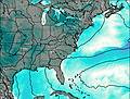
Live Weather:
At Wallops Island Airport, 12 km from Out Front.
light winds from the S
(km/h)Air temperature
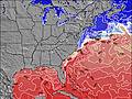
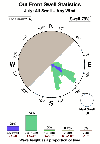
25.0°COverall Out Front Surf Consistency and Wind Distribution in July
surffoto's uit
de galerijContourlijnen: Wegen & Rivieren: Kies een surflokatie uit het menu 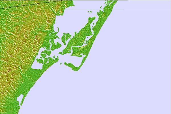
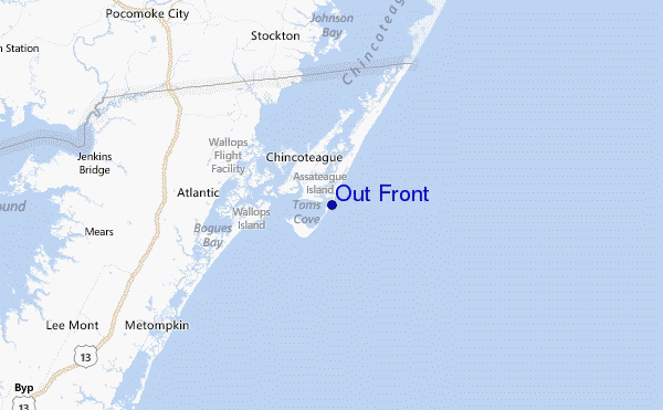
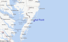
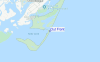
Gebruik deze reliëfkaart om naar de surfspots en de getijdenstations van Virginia toe te gaan, in de buurt van Out Front.
Andere Dichtbijzijnde Surflocaties van Out Front:
(klik op locatienaam voor meer informatie)- Closest Locatie2 mi
- Second closest Locatie25 mi
- Third closest Locatie32 mi
- Fourth closest Locatie32 mi
- Fifth closest Locatie32 mi
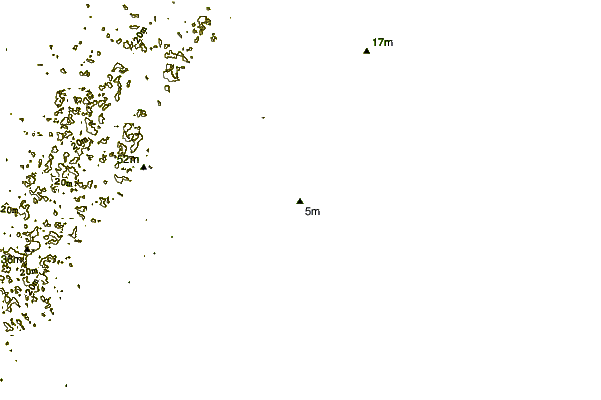
Dichtstbijzijnde golfboeien bij Out Front:
- Closest golfboei9 mi
- Second closest golfboei53 mi
- Third closest golfboei55 mi
- Fourth closest golfboei55 mi
- Fifth closest golfboei65 mi
Getijdenstations in de buurt van Out Front:
- Closest getijdenstationAssateague Beach, Toms Cove, Chincoteague Bay2 mi
- Second closest getijdenstationChincoteague Channel, South End4 mi
- Third closest getijdenstationChincoteague Island, Lewis Creek, Chincoteague Bay4 mi
- Fourth closest getijdenstationChincoteague Island, Oyster Bay, Chincoteague Bay4 mi
- Fifth closest getijdenstationChincoteague Island, USCG Station, Chincoteague Bay4 mi
Airports
- The closest passenger airport to Out Front is Wallops Flight Facility Airport (WAL) in USA, 12 km (7 miles) away (directly).
- The second nearest airport to Out Front is Salisbury Ocean City Wicomico Rgnl Airport (SBY), also in USA, 52 km (32 miles) away.
- Third is Patuxent River Nas Airport (NHK) in USA, 104 km (65 miles) away.
- Langley Afb (Hampton) Airport (LFI) in USA is 127 km (79 miles) away.
- Cape May Co (Wildwood) Airport (WWD), also in USA is the fifth nearest airport to Out Front and is 130 km (81 miles) away.
- /breaks/Out-Front/forecasts/latest


 Nearest