
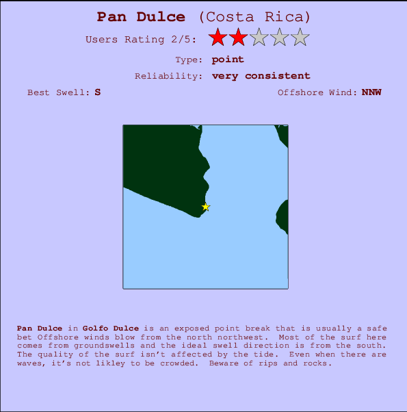
Pan Dulce Surf Guide
Pan Dulce in Golfo Dulce is an exposed point break that is usually a safe bet The best wind direction is from the north northwest. Groundswells more frequent than windswells and the best swell direction is from the south. Even when there are waves, it's not likley to be crowded. Watch out for rips and rocks.
Pan Dulce Spot Info
| Type: | Rating: | Reliability: | Todays Sea Temp*: |
|---|---|---|---|
| very consistent | 30.5°C*ocean temperature recorded from satellite |
Surfing Pan Dulce:
The best conditions reported for surf at Pan Dulce occur when a South swell combines with an offshore wind direction from the North-northwest.

Voorspelde Golfenergie (Kracht): 12 uur


Pan Dulce Surf:
Wednesday, 15 July 2026, 16:45 Local time| Wednesday 15 | Thu | |||
| 3PM | 6PM | 9PM | 0AM | |
| Wave (m) | ||||
| Periode (s) | 15 | 16 | 16 | 16 |
| Wind (km/h) | ||||
| Wind | cross | cross- off |
cross- off |
off |
- /breaks/Pan-Dulce/forecasts/latest
Pan Dulce Surf Guide
Pan Dulce in Golfo Dulce is an exposed point break that is usually a safe bet The best wind direction is from the north northwest. Groundswells more frequent than windswells and the best swell direction is from the south. Even when there are waves, it's not likley to be crowded. Watch out for rips and rocks.
Pan Dulce Spot Info
Type: Rating: Reliability: Todays Sea Temp*:  Point
Point 2
2very consistent 30.5°C*ocean temperature recorded from satelliteSurfing Pan Dulce:
The best conditions reported for surf at Pan Dulce occur when a South swell combines with an offshore wind direction from the North-northwest.
Voorspelde Golfenergie (Kracht): 12 uur
Gebruik de tabbladen hierboven om de zeewatertemperatuur bij Pan Dulce te bekijken, foto's van Pan Dulce, Pan Dulce gedetailleerde golfvoorspellingen, wind- en weersvoorspellingen, Pan Dulce webcams, actuele wind in Golfo Dulce live weerstations en Pan Dulce getijdenvoorspellingen. De link van Costa Rica golfkaarten opent een grote afbeelding van Costa Rica en de omliggende zeeën. Deze golfkaarten kunnen worden dynamisch gemaakt worden met de verschillende golfcomponenten, golfenergie, golfperiode, golfhoogte, samen met de wind en weersvoorspellingen, het actuele weer en de zeetoestand volgens golfboeien uit Costa Rica, langskomende schepen en weerstations op de kust. Elk voorspelling pagina's voor dit surfstrand zijn voorzien van een wereldwijde en regionale golfzoeker om de beste surfsomstandigheden in het gebied rond Pan Dulce te vinden.
Pan Dulce Surf:
Wednesday, 15 July 2026, 16:45 Local timeWednesday 15 Thu 3PM 6PM 9PM 0AM Wave (m) Periode (s) 15 16 16 16 Wind (km/h) Wind cross cross-
offcross-
offoff - /breaks/Pan-Dulce/forecasts/latest
- /breaks/Pan-Dulce/forecasts/latest/six_day
Pan Dulce Surf Guide
Pan Dulce in Golfo Dulce is an exposed point break that is usually a safe bet The best wind direction is from the north northwest. Groundswells more frequent than windswells and the best swell direction is from the south. Even when there are waves, it's not likley to be crowded. Watch out for rips and rocks.
Pan Dulce Spot Info
Type: Rating: Reliability: Todays Sea Temp*: Point2very consistent 30.5°C*ocean temperature recorded from satelliteSurfing Pan Dulce:
The best conditions reported for surf at Pan Dulce occur when a South swell combines with an offshore wind direction from the North-northwest.
Voorspelde Golfenergie (Kracht): 12 uur
Gebruik de tabbladen hierboven om de zeewatertemperatuur bij Pan Dulce te bekijken, foto's van Pan Dulce, Pan Dulce gedetailleerde golfvoorspellingen, wind- en weersvoorspellingen, Pan Dulce webcams, actuele wind in Golfo Dulce live weerstations en Pan Dulce getijdenvoorspellingen. De link van Costa Rica golfkaarten opent een grote afbeelding van Costa Rica en de omliggende zeeën. Deze golfkaarten kunnen worden dynamisch gemaakt worden met de verschillende golfcomponenten, golfenergie, golfperiode, golfhoogte, samen met de wind en weersvoorspellingen, het actuele weer en de zeetoestand volgens golfboeien uit Costa Rica, langskomende schepen en weerstations op de kust. Elk voorspelling pagina's voor dit surfstrand zijn voorzien van een wereldwijde en regionale golfzoeker om de beste surfsomstandigheden in het gebied rond Pan Dulce te vinden.
Pan Dulce Surf:
Wednesday, 15 July 2026, 16:45 Local timeWednesday 15 Thu 3PM 6PM 9PM 0AM Wave (m) Periode (s) 15 16 16 16 Wind (km/h) Wind cross cross-
offcross-
offoff - /breaks/Pan-Dulce/forecasts/latest
Pan Dulce Surf Guide
Pan Dulce in Golfo Dulce is an exposed point break that is usually a safe bet The best wind direction is from the north northwest. Groundswells more frequent than windswells and the best swell direction is from the south. Even when there are waves, it's not likley to be crowded. Watch out for rips and rocks.
Pan Dulce Spot Info
Type: Rating: Reliability: Todays Sea Temp*: Point2very consistent 30.5°C*ocean temperature recorded from satelliteSurfing Pan Dulce:
The best conditions reported for surf at Pan Dulce occur when a South swell combines with an offshore wind direction from the North-northwest.
Voorspelde Golfenergie (Kracht): 12 uur
Gebruik de tabbladen hierboven om de zeewatertemperatuur bij Pan Dulce te bekijken, foto's van Pan Dulce, Pan Dulce gedetailleerde golfvoorspellingen, wind- en weersvoorspellingen, Pan Dulce webcams, actuele wind in Golfo Dulce live weerstations en Pan Dulce getijdenvoorspellingen. De link van Costa Rica golfkaarten opent een grote afbeelding van Costa Rica en de omliggende zeeën. Deze golfkaarten kunnen worden dynamisch gemaakt worden met de verschillende golfcomponenten, golfenergie, golfperiode, golfhoogte, samen met de wind en weersvoorspellingen, het actuele weer en de zeetoestand volgens golfboeien uit Costa Rica, langskomende schepen en weerstations op de kust. Elk voorspelling pagina's voor dit surfstrand zijn voorzien van een wereldwijde en regionale golfzoeker om de beste surfsomstandigheden in het gebied rond Pan Dulce te vinden.
Pan Dulce Surf:
Wednesday, 15 July 2026, 16:45 Local timeWednesday 15 Thu 3PM 6PM 9PM 0AM Wave (m) Periode (s) 15 16 16 16 Wind (km/h) Wind cross cross-
offcross-
offoff Tide Times:
Voor Backwash, %{dist} %{km} van %{location}.
VOLGENDE IS OM (lokale tijd) resterende tijd hoog water laag water Pan Dulce Tide Times and Tide Chart
Live Weather:
At Puerto Armuelles wx, 48 km from Pan Dulce.
wind obs. (8 kph from 190 degs) was rejected
(km/h)
dryAir temperature
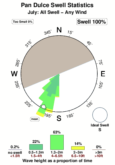
27°COverall Pan Dulce Surf Consistency and Wind Distribution in July
surffoto's uit
de galerijContourlijnen: Wegen & Rivieren: Kies een surflokatie uit het menu 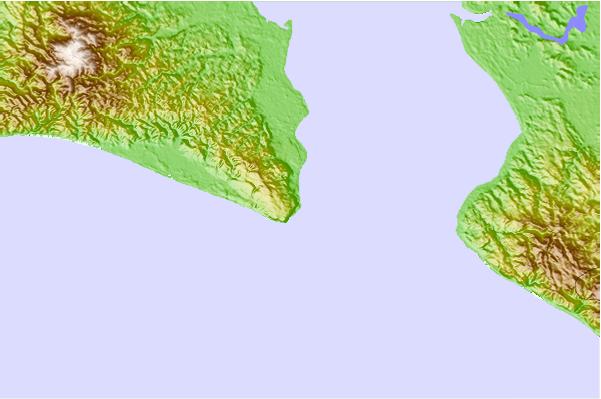
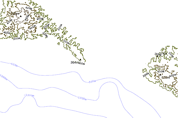
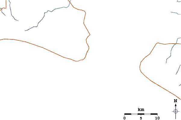
Gebruik deze reliëfkaart om naar de surfspots en de getijdenstations van Golfo Dulce toe te gaan, in de buurt van Pan Dulce.
Andere Dichtbijzijnde Surflocaties van Pan Dulce:
(klik op locatienaam voor meer informatie)- Closest Locatie1 mi
- Second closest Locatie1 mi
- Third closest Locatie1 mi
- Fourth closest Locatie6 mi
- Fifth closest Locatie9 mi
Dichtstbijzijnde golfboeien bij Pan Dulce:
- Closest golfboei595 mi
- Second closest golfboei802 mi
- Third closest golfboei1183 mi
- Fourth closest golfboei1196 mi
- Fifth closest golfboei1224 mi
Getijdenstations in de buurt van Pan Dulce:
- Closest getijdenstationGolfito19 mi
- Second closest getijdenstationPuerto Armuelles30 mi
- Third closest getijdenstationPedregal58 mi
- Fourth closest getijdenstationAlmirante87 mi
- Fifth closest getijdenstationBocas del Toro, Almirante Bay96 mi
Airports
- The closest passenger airport to Pan Dulce is Golfito Airport (GLF) in Costa Rica, 31 km (19 miles) away (directly).
- The second nearest airport to Pan Dulce is Coto 47 Airport (OTR), also in Costa Rica, 41 km (25 miles) away.
- Third is Palmar Sur Airport (PMZ) in Costa Rica, 65 km (40 miles) away.
- Enrique Malek International (David) Airport (DAV) in Panama is 93 km (58 miles) away.
- Cap Manuel Nino International (Changuinola) Airport (CHX), also in Panama is the fifth nearest airport to Pan Dulce and is 145 km (90 miles) away.
- /breaks/Pan-Dulce/forecasts/latest


 Nearest