
Peanuts Surf Guide
Peanuts in Timor is an exposed reef break that has dependable surf. May-Oct (Dry Season) is the best time of year for waves. Ideal winds are from the east northeast. Tends to receive distant groundswells and the ideal swell direction is from the southwest. A left hand reef. Unlikely to be too crowded, even when the surf is up. Watch out for rocks.
Peanuts Spot Info
| Type: | Rating: | Reliability: | Todays Sea Temp*: |
|---|---|---|---|
| consistent | 27.2°C*ocean temperature recorded from satellite |
Surfing Peanuts:
The best conditions reported for surf at Peanuts occur when a Southwest swell combines with an offshore wind direction from the East-northeast.

Voorspelde Golfenergie (Kracht): 12 uur


Peanuts Surf:
Tuesday, 21 July 2026, 14:05 Local time| Tuesday 21 | ||||
| 11AM | 2PM | 5PM | 8PM | |
| Wave (m) | ||||
| Periode (s) | 14 | 14 | 14 | 14 |
| Wind (km/h) | ||||
| Wind | cross- off |
cross- off |
cross- off |
cross- off |
- /breaks/Peanuts/forecasts/latest
Peanuts Surf Guide
Peanuts in Timor is an exposed reef break that has dependable surf. May-Oct (Dry Season) is the best time of year for waves. Ideal winds are from the east northeast. Tends to receive distant groundswells and the ideal swell direction is from the southwest. A left hand reef. Unlikely to be too crowded, even when the surf is up. Watch out for rocks.
Peanuts Spot Info
Type: Rating: Reliability: Todays Sea Temp*:  Reef
Reef 5
5consistent 27.2°C*ocean temperature recorded from satelliteSurfing Peanuts:
The best conditions reported for surf at Peanuts occur when a Southwest swell combines with an offshore wind direction from the East-northeast.
Voorspelde Golfenergie (Kracht): 12 uur
Gebruik de tabbladen hierboven om de zeewatertemperatuur bij Peanuts te bekijken, foto's van Peanuts, Peanuts gedetailleerde golfvoorspellingen, wind- en weersvoorspellingen, Peanuts webcams, actuele wind in Timor live weerstations en Peanuts getijdenvoorspellingen. De link van Indonesia golfkaarten opent een grote afbeelding van Indonesia en de omliggende zeeën. Deze golfkaarten kunnen worden dynamisch gemaakt worden met de verschillende golfcomponenten, golfenergie, golfperiode, golfhoogte, samen met de wind en weersvoorspellingen, het actuele weer en de zeetoestand volgens golfboeien uit Indonesia, langskomende schepen en weerstations op de kust. Elk voorspelling pagina's voor dit surfstrand zijn voorzien van een wereldwijde en regionale golfzoeker om de beste surfsomstandigheden in het gebied rond Peanuts te vinden.
Peanuts Surf:
Tuesday, 21 July 2026, 14:05 Local timeTuesday 21 11AM 2PM 5PM 8PM Wave (m) Periode (s) 14 14 14 14 Wind (km/h) Wind cross-
offcross-
offcross-
offcross-
off- /breaks/Peanuts/forecasts/latest
- /breaks/Peanuts/forecasts/latest/six_day
Peanuts Surf Guide
Peanuts in Timor is an exposed reef break that has dependable surf. May-Oct (Dry Season) is the best time of year for waves. Ideal winds are from the east northeast. Tends to receive distant groundswells and the ideal swell direction is from the southwest. A left hand reef. Unlikely to be too crowded, even when the surf is up. Watch out for rocks.
Peanuts Spot Info
Type: Rating: Reliability: Todays Sea Temp*: Reef5consistent 27.2°C*ocean temperature recorded from satelliteSurfing Peanuts:
The best conditions reported for surf at Peanuts occur when a Southwest swell combines with an offshore wind direction from the East-northeast.
Voorspelde Golfenergie (Kracht): 12 uur
Gebruik de tabbladen hierboven om de zeewatertemperatuur bij Peanuts te bekijken, foto's van Peanuts, Peanuts gedetailleerde golfvoorspellingen, wind- en weersvoorspellingen, Peanuts webcams, actuele wind in Timor live weerstations en Peanuts getijdenvoorspellingen. De link van Indonesia golfkaarten opent een grote afbeelding van Indonesia en de omliggende zeeën. Deze golfkaarten kunnen worden dynamisch gemaakt worden met de verschillende golfcomponenten, golfenergie, golfperiode, golfhoogte, samen met de wind en weersvoorspellingen, het actuele weer en de zeetoestand volgens golfboeien uit Indonesia, langskomende schepen en weerstations op de kust. Elk voorspelling pagina's voor dit surfstrand zijn voorzien van een wereldwijde en regionale golfzoeker om de beste surfsomstandigheden in het gebied rond Peanuts te vinden.
Peanuts Surf:
Tuesday, 21 July 2026, 14:05 Local timeTuesday 21 11AM 2PM 5PM 8PM Wave (m) Periode (s) 14 14 14 14 Wind (km/h) Wind cross-
offcross-
offcross-
offcross-
off- /breaks/Peanuts/forecasts/latest
Peanuts Surf Guide
Peanuts in Timor is an exposed reef break that has dependable surf. May-Oct (Dry Season) is the best time of year for waves. Ideal winds are from the east northeast. Tends to receive distant groundswells and the ideal swell direction is from the southwest. A left hand reef. Unlikely to be too crowded, even when the surf is up. Watch out for rocks.
Peanuts Spot Info
Type: Rating: Reliability: Todays Sea Temp*: Reef5consistent 27.2°C*ocean temperature recorded from satelliteSurfing Peanuts:
The best conditions reported for surf at Peanuts occur when a Southwest swell combines with an offshore wind direction from the East-northeast.
Voorspelde Golfenergie (Kracht): 12 uur
Gebruik de tabbladen hierboven om de zeewatertemperatuur bij Peanuts te bekijken, foto's van Peanuts, Peanuts gedetailleerde golfvoorspellingen, wind- en weersvoorspellingen, Peanuts webcams, actuele wind in Timor live weerstations en Peanuts getijdenvoorspellingen. De link van Indonesia golfkaarten opent een grote afbeelding van Indonesia en de omliggende zeeën. Deze golfkaarten kunnen worden dynamisch gemaakt worden met de verschillende golfcomponenten, golfenergie, golfperiode, golfhoogte, samen met de wind en weersvoorspellingen, het actuele weer en de zeetoestand volgens golfboeien uit Indonesia, langskomende schepen en weerstations op de kust. Elk voorspelling pagina's voor dit surfstrand zijn voorzien van een wereldwijde en regionale golfzoeker om de beste surfsomstandigheden in het gebied rond Peanuts te vinden.
Peanuts Surf:
Tuesday, 21 July 2026, 14:05 Local timeTuesday 21 11AM 2PM 5PM 8PM Wave (m) Periode (s) 14 14 14 14 Wind (km/h) Wind cross-
offcross-
offcross-
offcross-
offTide Times:
Voor Boa, %{dist} %{km} van %{location}.
VOLGENDE IS OM (lokale tijd) resterende tijd hoog water laag water Peanuts Tide Times and Tide Chart
Live Weather:
At El Tari International Airport (Kupang), 124 km from Peanuts.
fresh winds from the ESE
(km/h)
Dry and partly cloudyAir temperature
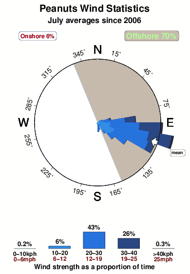
29°COverall Peanuts Surf Consistency and Wind Distribution in July
surffoto's uit
de galerijContourlijnen: Wegen & Rivieren: Kies een surflokatie uit het menu 


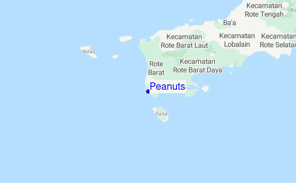
Gebruik deze reliëfkaart om naar de surfspots en de getijdenstations van Timor toe te gaan, in de buurt van Peanuts.
Dichtstbijzijnde golfboeien bij Peanuts:
- Closest golfboei1282 mi
- Second closest golfboei1587 mi
- Third closest golfboei1712 mi
- Fourth closest golfboei1791 mi
- Fifth closest golfboei1888 mi
Getijdenstations in de buurt van Peanuts:
- Closest getijdenstationKupang67 mi
- Second closest getijdenstationAshmore Reef90 mi
- Third closest getijdenstationPee Shoal148 mi
- Fourth closest getijdenstationEndeh164 mi
- Fifth closest getijdenstationMaumere165 mi
Airports
- The nearest passenger airport to Peanuts is El Tari (Kupang) Airport (KOE) in Indonesia, which is 124 km (77 miles) away (directly).
- The second closest airport to Peanuts is Wai Oti (Maumere) Airport (MOF), also in Indonesia, 262 km (163 miles) away.

- /breaks/Peanuts/forecasts/latest


 Nearest