
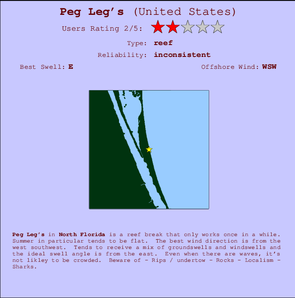
Peg Leg's Surf Guide
Peg Leg's in North Florida is an exposed reef break that only works once in a while. Summer in particular tends to be flat. Works best in offshore winds from the west southwest. Tends to receive a mix of groundswells and windswells and the best swell direction is from the east. Rarely crowded here. Take care of - Rips / undertow - Rocks - Localism - Sharks.
Peg Leg's Spot Info
| Type: | Rating: | Reliability: | Todays Sea Temp*: |
|---|---|---|---|
| inconsistent | 28.9°C*ocean temperature recorded from satellite |
Surfing Peg Leg's:
The best conditions reported for surf at Peg Leg's occur when a East swell combines with an offshore wind direction from the West-southwest.
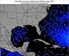
Voorspelde Golfenergie (Kracht): 12 uur

Peg Leg's Surf:
Monday, 3 August 2026, 10:30 Local time| Monday 03 | ||||
| 11AM | 2PM | 5PM | 8PM | |
| Wave (m) | ||||
| Periode (s) | 8 | 8 | 8 | 8 |
| Wind (km/h) | ||||
| Wind | cross- off |
off | glass | cross- on |
- /breaks/Peg-Leg-s/forecasts/latest
Peg Leg's Surf Guide
Peg Leg's in North Florida is an exposed reef break that only works once in a while. Summer in particular tends to be flat. Works best in offshore winds from the west southwest. Tends to receive a mix of groundswells and windswells and the best swell direction is from the east. Rarely crowded here. Take care of - Rips / undertow - Rocks - Localism - Sharks.
Peg Leg's Spot Info
Type: Rating: Reliability: Todays Sea Temp*:  Reef
Reef 2
2inconsistent 28.9°C*ocean temperature recorded from satelliteSurfing Peg Leg's:
The best conditions reported for surf at Peg Leg's occur when a East swell combines with an offshore wind direction from the West-southwest.
Voorspelde Golfenergie (Kracht): 12 uur
Gebruik de tabbladen hierboven om de zeewatertemperatuur bij Peg Leg's te bekijken, foto's van Peg Leg's, Peg Leg's gedetailleerde golfvoorspellingen, wind- en weersvoorspellingen, Peg Leg's webcams, actuele wind in Florida - North live weerstations en Peg Leg's getijdenvoorspellingen. De link van United States golfkaarten opent een grote afbeelding van United States en de omliggende zeeën. Deze golfkaarten kunnen worden dynamisch gemaakt worden met de verschillende golfcomponenten, golfenergie, golfperiode, golfhoogte, samen met de wind en weersvoorspellingen, het actuele weer en de zeetoestand volgens golfboeien uit United States, langskomende schepen en weerstations op de kust. Elk voorspelling pagina's voor dit surfstrand zijn voorzien van een wereldwijde en regionale golfzoeker om de beste surfsomstandigheden in het gebied rond Peg Leg's te vinden.
Peg Leg's Surf:
Monday, 3 August 2026, 10:30 Local timeMonday 03 11AM 2PM 5PM 8PM Wave (m) Periode (s) 8 8 8 8 Wind (km/h) Wind cross-
offoff glass cross-
on- /breaks/Peg-Leg-s/forecasts/latest
- /breaks/Peg-Leg-s/forecasts/latest/six_day
Peg Leg's Surf Guide
Peg Leg's in North Florida is an exposed reef break that only works once in a while. Summer in particular tends to be flat. Works best in offshore winds from the west southwest. Tends to receive a mix of groundswells and windswells and the best swell direction is from the east. Rarely crowded here. Take care of - Rips / undertow - Rocks - Localism - Sharks.
Peg Leg's Spot Info
Type: Rating: Reliability: Todays Sea Temp*: Reef2inconsistent 28.9°C*ocean temperature recorded from satelliteSurfing Peg Leg's:
The best conditions reported for surf at Peg Leg's occur when a East swell combines with an offshore wind direction from the West-southwest.
Voorspelde Golfenergie (Kracht): 12 uur
Gebruik de tabbladen hierboven om de zeewatertemperatuur bij Peg Leg's te bekijken, foto's van Peg Leg's, Peg Leg's gedetailleerde golfvoorspellingen, wind- en weersvoorspellingen, Peg Leg's webcams, actuele wind in Florida - North live weerstations en Peg Leg's getijdenvoorspellingen. De link van United States golfkaarten opent een grote afbeelding van United States en de omliggende zeeën. Deze golfkaarten kunnen worden dynamisch gemaakt worden met de verschillende golfcomponenten, golfenergie, golfperiode, golfhoogte, samen met de wind en weersvoorspellingen, het actuele weer en de zeetoestand volgens golfboeien uit United States, langskomende schepen en weerstations op de kust. Elk voorspelling pagina's voor dit surfstrand zijn voorzien van een wereldwijde en regionale golfzoeker om de beste surfsomstandigheden in het gebied rond Peg Leg's te vinden.
Peg Leg's Surf:
Monday, 3 August 2026, 10:30 Local timeMonday 03 11AM 2PM 5PM 8PM Wave (m) Periode (s) 8 8 8 8 Wind (km/h) Wind cross-
offoff glass cross-
on- /breaks/Peg-Leg-s/forecasts/latest
Peg Leg's Surf Guide
Peg Leg's in North Florida is an exposed reef break that only works once in a while. Summer in particular tends to be flat. Works best in offshore winds from the west southwest. Tends to receive a mix of groundswells and windswells and the best swell direction is from the east. Rarely crowded here. Take care of - Rips / undertow - Rocks - Localism - Sharks.
Peg Leg's Spot Info
Type: Rating: Reliability: Todays Sea Temp*: Reef2inconsistent 28.9°C*ocean temperature recorded from satelliteSurfing Peg Leg's:
The best conditions reported for surf at Peg Leg's occur when a East swell combines with an offshore wind direction from the West-southwest.
Voorspelde Golfenergie (Kracht): 12 uur
Gebruik de tabbladen hierboven om de zeewatertemperatuur bij Peg Leg's te bekijken, foto's van Peg Leg's, Peg Leg's gedetailleerde golfvoorspellingen, wind- en weersvoorspellingen, Peg Leg's webcams, actuele wind in Florida - North live weerstations en Peg Leg's getijdenvoorspellingen. De link van United States golfkaarten opent een grote afbeelding van United States en de omliggende zeeën. Deze golfkaarten kunnen worden dynamisch gemaakt worden met de verschillende golfcomponenten, golfenergie, golfperiode, golfhoogte, samen met de wind en weersvoorspellingen, het actuele weer en de zeetoestand volgens golfboeien uit United States, langskomende schepen en weerstations op de kust. Elk voorspelling pagina's voor dit surfstrand zijn voorzien van een wereldwijde en regionale golfzoeker om de beste surfsomstandigheden in het gebied rond Peg Leg's te vinden.
Peg Leg's Surf:
Monday, 3 August 2026, 10:30 Local timeMonday 03 11AM 2PM 5PM 8PM Wave (m) Periode (s) 8 8 8 8 Wind (km/h) Wind cross-
offoff glass cross-
onTide Times:
Voor Satellite Beach, %{dist} %{km} van %{location}.
VOLGENDE IS OM (lokale tijd) resterende tijd hoog water laag water Peg Leg's Tide Times and Tide Chart
Live Weather:
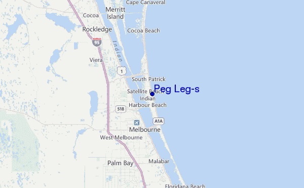
At Patrick Air Force Base Airport, 6 km from Peg Leg's.
light winds from the SSW
(km/h)
Light rainAir temperature
26.6°CCurrent weather near Peg Leg's
Buoy Data:
At Cape Canaveral Nearshore, FL, 17 miles from Peg Leg's.
5AM 6AM 7AM 8AM Gegevens Leeftijd 4 hr 3 hr 2 hr 1 hr Golfhoogte (m) 

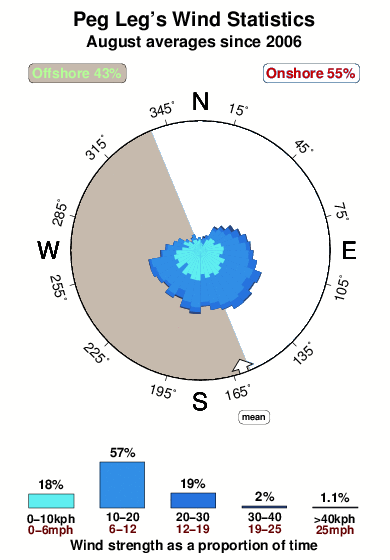
Dominante Periode (s) 8 8 8 8 Overall Peg Leg's Surf Consistency and Wind Distribution in August
surffoto's uit
de galerijContourlijnen: Wegen & Rivieren: Kies een surflokatie uit het menu 


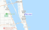
Gebruik deze reliëfkaart om naar de surfspots en de getijdenstations van Florida - North toe te gaan, in de buurt van Peg Leg's.
Andere Dichtbijzijnde Surflocaties van Peg Leg's:
(klik op locatienaam voor meer informatie)- Closest Locatie1 mi
- Second closest Locatie1 mi
- Third closest Locatie1 mi
- Fourth closest Locatie2 mi
- Fifth closest Locatie3 mi
Dichtstbijzijnde golfboeien bij Peg Leg's:
- Closest golfboei17 mi
- Second closest golfboei30 mi
- Third closest golfboei35 mi
- Fourth closest golfboei48 mi
- Fifth closest golfboei130 mi
Getijdenstations in de buurt van Peg Leg's:
- Closest getijdenstationSatellite Beach1 mi
- Second closest getijdenstationCanova Beach2 mi
- Third closest getijdenstationSouth Patrick Shores3 mi
- Fourth closest getijdenstationPatrick Air Force Base6 mi
- Fifth closest getijdenstationPalm Bay9 mi
Airports
- The closest passenger airport to Peg Leg's is Patrick Afb (Coco Beach) Airport (COF) in USA, 8 km (5 miles) away (directly).
- The second nearest airport to Peg Leg's is Melbourne International Airport (MLB), also in USA, 9 km (6 miles) away.
- Third is Vero Beach Muni Airport (VRB) in USA, 59 km (37 miles) away.
- Orlando International Airport (MCO) in USA is 77 km (48 miles) away.
- Executive (Orlando) Airport (ORL), also in USA is the fifth nearest airport to Peg Leg's and is 84 km (52 miles) away.
- /breaks/Peg-Leg-s/forecasts/latest


 Nearest