

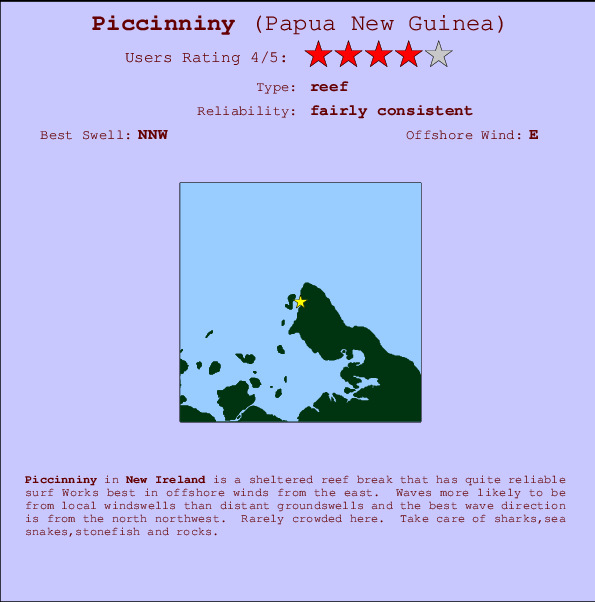
Piccinniny Surf Guide
Piccinniny in Kavieng is a fairly exposed point/Wharf break that has quite consistent surf The best wind direction is from the east. Windswells are much more typical than groudswells and the ideal wave direction is from the north. Relatively few surfers here, even on good days. Beware of sharks,sea snakes,stonefish and rocks.
Piccinniny Spot Info
| Type: | Rating: | Reliability: | Todays Sea Temp*: |
|---|---|---|---|
| fairly consistent | 29.1°C*ocean temperature recorded from satellite |
Surfing Piccinniny:
The best conditions reported for surf at Piccinniny occur when a North-northwest swell combines with an offshore wind direction from the East.
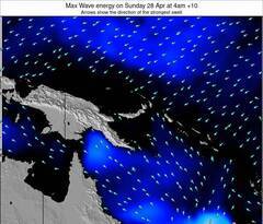
Voorspelde Golfenergie (Kracht): 12 uur

Piccinniny Surf:
Thursday, 16 July 2026, 15:46 Local time| Thursday 16 | ||||
| 7AM | 10AM | 1PM | 4PM | |
| Wave (m) | ||||
| Periode (s) | 9 | 9 | 9 | 9 |
| Wind (km/h) | ||||
| Wind | cross | cross- off |
cross- off |
cross- off |
- /breaks/Piccinniny/forecasts/latest
Piccinniny Surf Guide
Piccinniny in Kavieng is a fairly exposed point/Wharf break that has quite consistent surf The best wind direction is from the east. Windswells are much more typical than groudswells and the ideal wave direction is from the north. Relatively few surfers here, even on good days. Beware of sharks,sea snakes,stonefish and rocks.
Piccinniny Spot Info
Type: Rating: Reliability: Todays Sea Temp*:  Reef
Reef 4
4fairly consistent 29.1°C*ocean temperature recorded from satelliteSurfing Piccinniny:
The best conditions reported for surf at Piccinniny occur when a North-northwest swell combines with an offshore wind direction from the East.
Voorspelde Golfenergie (Kracht): 12 uur
Gebruik de tabbladen hierboven om de zeewatertemperatuur bij Piccinniny te bekijken, foto's van Piccinniny, Piccinniny gedetailleerde golfvoorspellingen, wind- en weersvoorspellingen, Piccinniny webcams, actuele wind in New Ireland live weerstations en Piccinniny getijdenvoorspellingen. De link van Papua New Guinea golfkaarten opent een grote afbeelding van Papua New Guinea en de omliggende zeeën. Deze golfkaarten kunnen worden dynamisch gemaakt worden met de verschillende golfcomponenten, golfenergie, golfperiode, golfhoogte, samen met de wind en weersvoorspellingen, het actuele weer en de zeetoestand volgens golfboeien uit Papua New Guinea, langskomende schepen en weerstations op de kust. Elk voorspelling pagina's voor dit surfstrand zijn voorzien van een wereldwijde en regionale golfzoeker om de beste surfsomstandigheden in het gebied rond Piccinniny te vinden.
Piccinniny Surf:
Thursday, 16 July 2026, 15:46 Local timeThursday 16 7AM 10AM 1PM 4PM Wave (m) Periode (s) 9 9 9 9 Wind (km/h) Wind cross cross-
offcross-
offcross-
off- /breaks/Piccinniny/forecasts/latest
- /breaks/Piccinniny/forecasts/latest/six_day
Piccinniny Surf Guide
Piccinniny in Kavieng is a fairly exposed point/Wharf break that has quite consistent surf The best wind direction is from the east. Windswells are much more typical than groudswells and the ideal wave direction is from the north. Relatively few surfers here, even on good days. Beware of sharks,sea snakes,stonefish and rocks.
Piccinniny Spot Info
Type: Rating: Reliability: Todays Sea Temp*: Reef4fairly consistent 29.1°C*ocean temperature recorded from satelliteSurfing Piccinniny:
The best conditions reported for surf at Piccinniny occur when a North-northwest swell combines with an offshore wind direction from the East.
Voorspelde Golfenergie (Kracht): 12 uur
Gebruik de tabbladen hierboven om de zeewatertemperatuur bij Piccinniny te bekijken, foto's van Piccinniny, Piccinniny gedetailleerde golfvoorspellingen, wind- en weersvoorspellingen, Piccinniny webcams, actuele wind in New Ireland live weerstations en Piccinniny getijdenvoorspellingen. De link van Papua New Guinea golfkaarten opent een grote afbeelding van Papua New Guinea en de omliggende zeeën. Deze golfkaarten kunnen worden dynamisch gemaakt worden met de verschillende golfcomponenten, golfenergie, golfperiode, golfhoogte, samen met de wind en weersvoorspellingen, het actuele weer en de zeetoestand volgens golfboeien uit Papua New Guinea, langskomende schepen en weerstations op de kust. Elk voorspelling pagina's voor dit surfstrand zijn voorzien van een wereldwijde en regionale golfzoeker om de beste surfsomstandigheden in het gebied rond Piccinniny te vinden.
Piccinniny Surf:
Thursday, 16 July 2026, 15:46 Local timeThursday 16 7AM 10AM 1PM 4PM Wave (m) Periode (s) 9 9 9 9 Wind (km/h) Wind cross cross-
offcross-
offcross-
off- /breaks/Piccinniny/forecasts/latest
Piccinniny Surf Guide
Piccinniny in Kavieng is a fairly exposed point/Wharf break that has quite consistent surf The best wind direction is from the east. Windswells are much more typical than groudswells and the ideal wave direction is from the north. Relatively few surfers here, even on good days. Beware of sharks,sea snakes,stonefish and rocks.
Piccinniny Spot Info
Type: Rating: Reliability: Todays Sea Temp*: Reef4fairly consistent 29.1°C*ocean temperature recorded from satelliteSurfing Piccinniny:
The best conditions reported for surf at Piccinniny occur when a North-northwest swell combines with an offshore wind direction from the East.
Voorspelde Golfenergie (Kracht): 12 uur
Gebruik de tabbladen hierboven om de zeewatertemperatuur bij Piccinniny te bekijken, foto's van Piccinniny, Piccinniny gedetailleerde golfvoorspellingen, wind- en weersvoorspellingen, Piccinniny webcams, actuele wind in New Ireland live weerstations en Piccinniny getijdenvoorspellingen. De link van Papua New Guinea golfkaarten opent een grote afbeelding van Papua New Guinea en de omliggende zeeën. Deze golfkaarten kunnen worden dynamisch gemaakt worden met de verschillende golfcomponenten, golfenergie, golfperiode, golfhoogte, samen met de wind en weersvoorspellingen, het actuele weer en de zeetoestand volgens golfboeien uit Papua New Guinea, langskomende schepen en weerstations op de kust. Elk voorspelling pagina's voor dit surfstrand zijn voorzien van een wereldwijde en regionale golfzoeker om de beste surfsomstandigheden in het gebied rond Piccinniny te vinden.
Piccinniny Surf:
Thursday, 16 July 2026, 15:46 Local timeThursday 16 7AM 10AM 1PM 4PM Wave (m) Periode (s) 9 9 9 9 Wind (km/h) Wind cross cross-
offcross-
offcross-
offTide Times:
Voor Kavieng, Papua New Guinea, %{dist} %{km} van %{location}.
VOLGENDE IS OM (lokale tijd) resterende tijd hoog water laag water Piccinniny Tide Times and Tide Chart
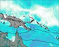
Live Weather:
At Kavieng W.o., 3 km from Piccinniny.
moderate winds from the S
(km/h)
no reportAir temperature
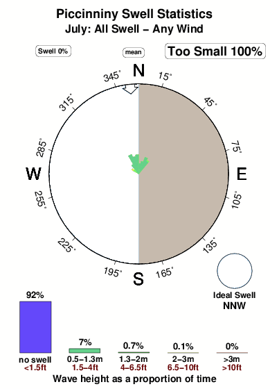
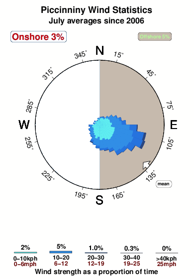
30.0°COverall Piccinniny Surf Consistency and Wind Distribution in July
surffoto's uit
de galerijContourlijnen: Wegen & Rivieren: Kies een surflokatie uit het menu 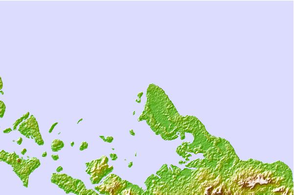
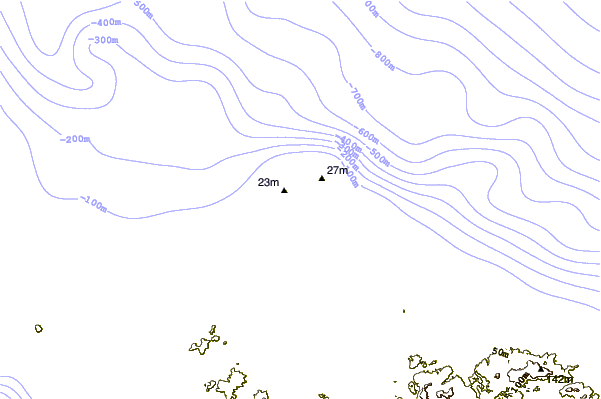
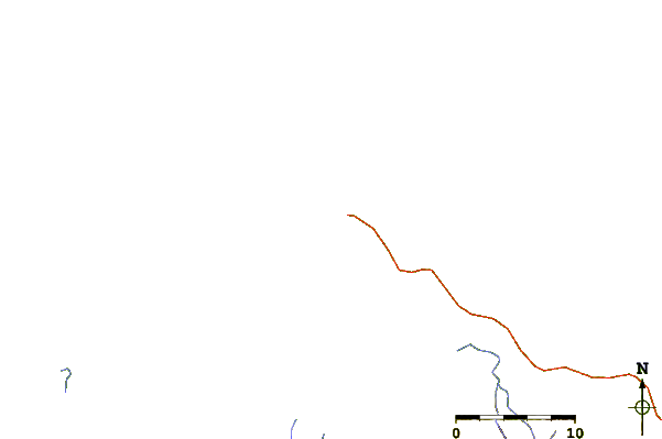
Gebruik deze reliëfkaart om naar de surfspots en de getijdenstations van New Ireland toe te gaan, in de buurt van Piccinniny.
Andere Dichtbijzijnde Surflocaties van Piccinniny:
(klik op locatienaam voor meer informatie)- Closest Locatie1 mi
- Second closest Locatie1 mi
- Third closest Locatie1 mi
- Fourth closest Locatie2 mi
- Fifth closest Locatie7 mi
Dichtstbijzijnde golfboeien bij Piccinniny:
- Closest golfboei936 mi
- Second closest golfboei1037 mi
- Third closest golfboei1173 mi
- Fourth closest golfboei1176 mi
- Fifth closest golfboei1196 mi
Getijdenstations in de buurt van Piccinniny:
- Closest getijdenstationKavieng1 mi
- Second closest getijdenstationRabaul147 mi
- Third closest getijdenstationKokopo160 mi
- Fourth closest getijdenstationKimbe208 mi
- Fifth closest getijdenstationPort Seeadler, Manus, Admiralty Islands247 mi
Airports
- The nearest passenger airport to Piccinniny is Madang Airport (MAG) in Papua New Guinea, which is 627 km (389 miles) away (directly).
- The second closest airport to Piccinniny is Nadzab Airport (LAE), also in Papua New Guinea, 632 km (393 miles) away.
- /breaks/Piccinniny/forecasts/latest


 Nearest