
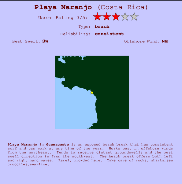
Playa Naranjo Surf Guide
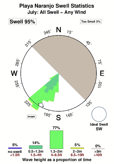
Playa Naranjo in Guanacaste is an exposed beach break that has consistent surf and can work at any time of the year. The best wind direction is from the northeast. Clean groundswells prevail and the ideal swell direction is from the southwest. Waves at the beach are both lefts and rights. It very rarely gets crowded here. Beware of rocks, sharks,sea crcodiles,sea-lice.
Playa Naranjo Spot Info
| Type: | Rating: | Reliability: | Todays Sea Temp*: |
|---|---|---|---|
| consistent | 29.5°C*ocean temperature recorded from satellite |
Surfing Playa Naranjo:
The best conditions reported for surf at Playa Naranjo occur when a Southwest swell combines with an offshore wind direction from the Northeast.

Voorspelde Golfenergie (Kracht): 12 uur


Playa Naranjo Surf:
Friday, 17 July 2026, 16:19 Local time| Friday 17 | Sat | |||
| 3PM | 6PM | 9PM | 0AM | |
| Wave (m) | ||||
| Periode (s) | 13 | 13 | 14 | 13 |
| Wind (km/h) | ||||
| Wind | off | off | off | off |
- /breaks/Playa-Naranjo/forecasts/latest
Playa Naranjo Surf Guide
Playa Naranjo in Guanacaste is an exposed beach break that has consistent surf and can work at any time of the year. The best wind direction is from the northeast. Clean groundswells prevail and the ideal swell direction is from the southwest. Waves at the beach are both lefts and rights. It very rarely gets crowded here. Beware of rocks, sharks,sea crcodiles,sea-lice.
Playa Naranjo Spot Info
Type: Rating: Reliability: Todays Sea Temp*:  Beach
Beach 3
3consistent 29.5°C*ocean temperature recorded from satelliteSurfing Playa Naranjo:
The best conditions reported for surf at Playa Naranjo occur when a Southwest swell combines with an offshore wind direction from the Northeast.
Voorspelde Golfenergie (Kracht): 12 uur
Gebruik de tabbladen hierboven om de zeewatertemperatuur bij Playa Naranjo te bekijken, foto's van Playa Naranjo, Playa Naranjo gedetailleerde golfvoorspellingen, wind- en weersvoorspellingen, Playa Naranjo webcams, actuele wind in Guanacaste live weerstations en Playa Naranjo getijdenvoorspellingen. De link van Costa Rica golfkaarten opent een grote afbeelding van Costa Rica en de omliggende zeeën. Deze golfkaarten kunnen worden dynamisch gemaakt worden met de verschillende golfcomponenten, golfenergie, golfperiode, golfhoogte, samen met de wind en weersvoorspellingen, het actuele weer en de zeetoestand volgens golfboeien uit Costa Rica, langskomende schepen en weerstations op de kust. Elk voorspelling pagina's voor dit surfstrand zijn voorzien van een wereldwijde en regionale golfzoeker om de beste surfsomstandigheden in het gebied rond Playa Naranjo te vinden.
Playa Naranjo Surf:
Friday, 17 July 2026, 16:19 Local timeFriday 17 Sat 3PM 6PM 9PM 0AM Wave (m) Periode (s) 13 13 14 13 Wind (km/h) Wind off off off off - /breaks/Playa-Naranjo/forecasts/latest
- /breaks/Playa-Naranjo/forecasts/latest/six_day
Playa Naranjo Surf Guide
Playa Naranjo in Guanacaste is an exposed beach break that has consistent surf and can work at any time of the year. The best wind direction is from the northeast. Clean groundswells prevail and the ideal swell direction is from the southwest. Waves at the beach are both lefts and rights. It very rarely gets crowded here. Beware of rocks, sharks,sea crcodiles,sea-lice.
Playa Naranjo Spot Info
Type: Rating: Reliability: Todays Sea Temp*: Beach3consistent 29.5°C*ocean temperature recorded from satelliteSurfing Playa Naranjo:
The best conditions reported for surf at Playa Naranjo occur when a Southwest swell combines with an offshore wind direction from the Northeast.
Voorspelde Golfenergie (Kracht): 12 uur
Gebruik de tabbladen hierboven om de zeewatertemperatuur bij Playa Naranjo te bekijken, foto's van Playa Naranjo, Playa Naranjo gedetailleerde golfvoorspellingen, wind- en weersvoorspellingen, Playa Naranjo webcams, actuele wind in Guanacaste live weerstations en Playa Naranjo getijdenvoorspellingen. De link van Costa Rica golfkaarten opent een grote afbeelding van Costa Rica en de omliggende zeeën. Deze golfkaarten kunnen worden dynamisch gemaakt worden met de verschillende golfcomponenten, golfenergie, golfperiode, golfhoogte, samen met de wind en weersvoorspellingen, het actuele weer en de zeetoestand volgens golfboeien uit Costa Rica, langskomende schepen en weerstations op de kust. Elk voorspelling pagina's voor dit surfstrand zijn voorzien van een wereldwijde en regionale golfzoeker om de beste surfsomstandigheden in het gebied rond Playa Naranjo te vinden.
Playa Naranjo Surf:
Friday, 17 July 2026, 16:19 Local timeFriday 17 Sat 3PM 6PM 9PM 0AM Wave (m) Periode (s) 13 13 14 13 Wind (km/h) Wind off off off off - /breaks/Playa-Naranjo/forecasts/latest
Playa Naranjo Surf Guide
Playa Naranjo in Guanacaste is an exposed beach break that has consistent surf and can work at any time of the year. The best wind direction is from the northeast. Clean groundswells prevail and the ideal swell direction is from the southwest. Waves at the beach are both lefts and rights. It very rarely gets crowded here. Beware of rocks, sharks,sea crcodiles,sea-lice.
Playa Naranjo Spot Info
Type: Rating: Reliability: Todays Sea Temp*: Beach3consistent 29.5°C*ocean temperature recorded from satelliteSurfing Playa Naranjo:
The best conditions reported for surf at Playa Naranjo occur when a Southwest swell combines with an offshore wind direction from the Northeast.
Voorspelde Golfenergie (Kracht): 12 uur
Gebruik de tabbladen hierboven om de zeewatertemperatuur bij Playa Naranjo te bekijken, foto's van Playa Naranjo, Playa Naranjo gedetailleerde golfvoorspellingen, wind- en weersvoorspellingen, Playa Naranjo webcams, actuele wind in Guanacaste live weerstations en Playa Naranjo getijdenvoorspellingen. De link van Costa Rica golfkaarten opent een grote afbeelding van Costa Rica en de omliggende zeeën. Deze golfkaarten kunnen worden dynamisch gemaakt worden met de verschillende golfcomponenten, golfenergie, golfperiode, golfhoogte, samen met de wind en weersvoorspellingen, het actuele weer en de zeetoestand volgens golfboeien uit Costa Rica, langskomende schepen en weerstations op de kust. Elk voorspelling pagina's voor dit surfstrand zijn voorzien van een wereldwijde en regionale golfzoeker om de beste surfsomstandigheden in het gebied rond Playa Naranjo te vinden.
Playa Naranjo Surf:
Friday, 17 July 2026, 16:19 Local timeFriday 17 Sat 3PM 6PM 9PM 0AM Wave (m) Periode (s) 13 13 14 13 Wind (km/h) Wind off off off off Tide Times:
Voor El Laberinto, %{dist} %{km} van %{location}.
VOLGENDE IS OM (lokale tijd) resterende tijd hoog water laag water Playa Naranjo Tide Times and Tide Chart
Live Weather:
At Liberia/Tomas Guardia Airport, 25 km from Playa Naranjo.
fresh winds from the E
(km/h)
Dry and partly cloudyAir temperature
33°COverall Playa Naranjo Surf Consistency and Wind Distribution in July
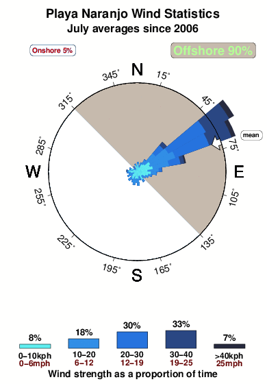


Wind stats for Playa Naranjo: see the variation in direction and stength by month.
surffoto's uit
de galerijContourlijnen: Wegen & Rivieren: Kies een surflokatie uit het menu 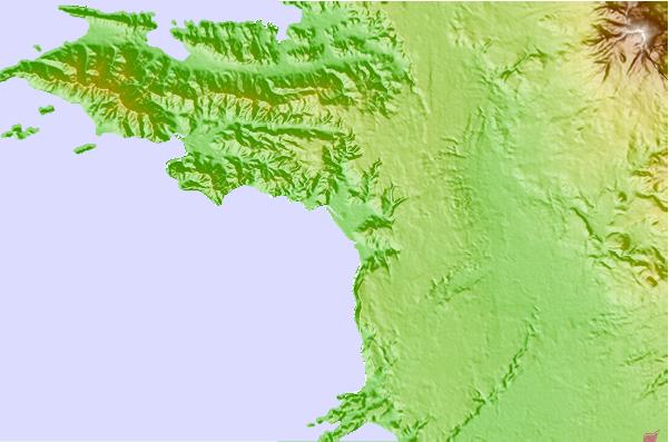

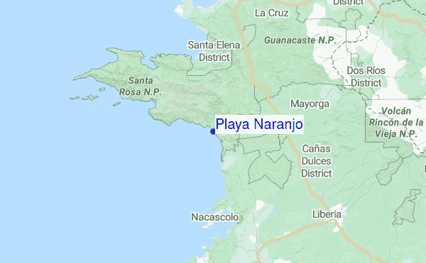
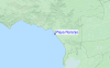
Gebruik deze reliëfkaart om naar de surfspots en de getijdenstations van Guanacaste toe te gaan, in de buurt van Playa Naranjo.
Andere Dichtbijzijnde Surflocaties van Playa Naranjo:
(klik op locatienaam voor meer informatie)- Closest Locatie0 mi
- Second closest Locatie4 mi
- Third closest Locatie9 mi
- Fourth closest Locatie12 mi
- Fifth closest Locatie22 mi
Dichtstbijzijnde golfboeien bij Playa Naranjo:
- Closest golfboei503 mi
- Second closest golfboei629 mi
- Third closest golfboei953 mi
- Fourth closest golfboei1039 mi
- Fifth closest golfboei1049 mi
Getijdenstations in de buurt van Playa Naranjo:
- Closest getijdenstationSan Juan del Sur34 mi
- Second closest getijdenstationPunta Arenas81 mi
- Third closest getijdenstationChacarita83 mi
- Fourth closest getijdenstationMasachapa89 mi
- Fifth closest getijdenstationSan Juan del Norte (Greytown)135 mi
Airports
- The closest passenger airport to Playa Naranjo is Daniel Oduber Quiros International (Liberia) Airport (LIR) in Costa Rica, 27 km (17 miles) away (directly).
- The second nearest airport to Playa Naranjo is Nosara Airport (NOB), also in Costa Rica, 91 km (57 miles) away.
- Third is Managua International Airport (MGA) in Nicaragua, 159 km (99 miles) away.
- Juan Santamaria International Airport (SJO) in Costa Rica is 184 km (114 miles) away.
- Quepos Managua Airport (XQP), also in Costa Rica is the fifth nearest airport to Playa Naranjo and is 226 km (140 miles) away.
- /breaks/Playa-Naranjo/forecasts/latest
 Nearest