
Playa Tamarindo Surf Guide
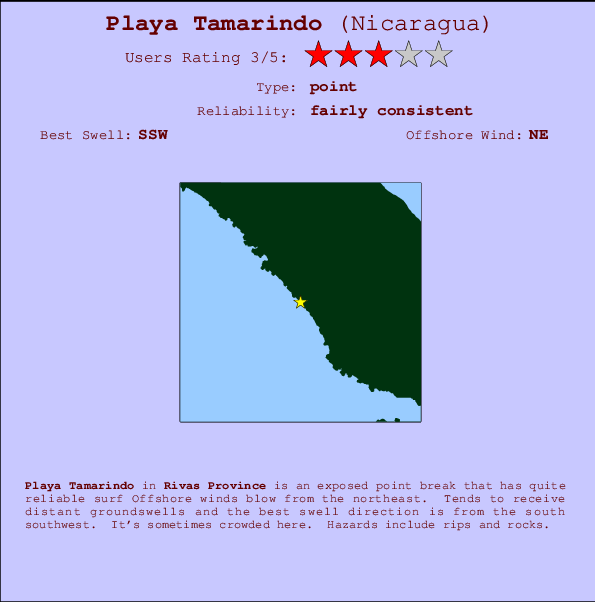
Playa Tamarindo in Rivas Province is an exposed point break that has pretty consitent surf Works best in offshore winds from the northeast. Tends to receive distant groundswells and the best swell direction is from the south southwest. It's sometimes crowded here. Hazards include rips and rocks.
Playa Tamarindo Spot Info
| Type: | Rating: | Reliability: | Todays Sea Temp*: |
|---|---|---|---|
| fairly consistent | 28.9°C*ocean temperature recorded from satellite |
Surfing Playa Tamarindo:
The best conditions reported for surf at Playa Tamarindo occur when a South-southwest swell combines with an offshore wind direction from the Northeast.

Voorspelde Golfenergie (Kracht): 12 uur


Playa Tamarindo Surf:
Saturday, 1 August 2026, 18:33 Local time| Saturday 01 | Sun | |||
| 3PM | 6PM | 9PM | 0AM | |
| Wave (m) | ||||
| Periode (s) | 13 | 13 | 12 | 12 |
| Wind (km/h) | ||||
| Wind | cross- off |
cross- off |
cross- off |
cross- off |
- /breaks/Playa-Tamarindo/forecasts/latest
Playa Tamarindo Surf Guide
Playa Tamarindo in Rivas Province is an exposed point break that has pretty consitent surf Works best in offshore winds from the northeast. Tends to receive distant groundswells and the best swell direction is from the south southwest. It's sometimes crowded here. Hazards include rips and rocks.
Playa Tamarindo Spot Info
Type: Rating: Reliability: Todays Sea Temp*:  Point
Point 3
3fairly consistent 28.9°C*ocean temperature recorded from satelliteSurfing Playa Tamarindo:
The best conditions reported for surf at Playa Tamarindo occur when a South-southwest swell combines with an offshore wind direction from the Northeast.
Voorspelde Golfenergie (Kracht): 12 uur
Gebruik de tabbladen hierboven om de zeewatertemperatuur bij Playa Tamarindo te bekijken, foto's van Playa Tamarindo, Playa Tamarindo gedetailleerde golfvoorspellingen, wind- en weersvoorspellingen, Playa Tamarindo webcams, actuele wind in Rivas Province live weerstations en Playa Tamarindo getijdenvoorspellingen. De link van Nicaragua golfkaarten opent een grote afbeelding van Nicaragua en de omliggende zeeën. Deze golfkaarten kunnen worden dynamisch gemaakt worden met de verschillende golfcomponenten, golfenergie, golfperiode, golfhoogte, samen met de wind en weersvoorspellingen, het actuele weer en de zeetoestand volgens golfboeien uit Nicaragua, langskomende schepen en weerstations op de kust. Elk voorspelling pagina's voor dit surfstrand zijn voorzien van een wereldwijde en regionale golfzoeker om de beste surfsomstandigheden in het gebied rond Playa Tamarindo te vinden.
Playa Tamarindo Surf:
Saturday, 1 August 2026, 18:33 Local timeSaturday 01 Sun 3PM 6PM 9PM 0AM Wave (m) Periode (s) 13 13 12 12 Wind (km/h) Wind cross-
offcross-
offcross-
offcross-
off- /breaks/Playa-Tamarindo/forecasts/latest
- /breaks/Playa-Tamarindo/forecasts/latest/six_day
Playa Tamarindo Surf Guide
Playa Tamarindo in Rivas Province is an exposed point break that has pretty consitent surf Works best in offshore winds from the northeast. Tends to receive distant groundswells and the best swell direction is from the south southwest. It's sometimes crowded here. Hazards include rips and rocks.
Playa Tamarindo Spot Info
Type: Rating: Reliability: Todays Sea Temp*: Point3fairly consistent 28.9°C*ocean temperature recorded from satelliteSurfing Playa Tamarindo:
The best conditions reported for surf at Playa Tamarindo occur when a South-southwest swell combines with an offshore wind direction from the Northeast.
Voorspelde Golfenergie (Kracht): 12 uur
Gebruik de tabbladen hierboven om de zeewatertemperatuur bij Playa Tamarindo te bekijken, foto's van Playa Tamarindo, Playa Tamarindo gedetailleerde golfvoorspellingen, wind- en weersvoorspellingen, Playa Tamarindo webcams, actuele wind in Rivas Province live weerstations en Playa Tamarindo getijdenvoorspellingen. De link van Nicaragua golfkaarten opent een grote afbeelding van Nicaragua en de omliggende zeeën. Deze golfkaarten kunnen worden dynamisch gemaakt worden met de verschillende golfcomponenten, golfenergie, golfperiode, golfhoogte, samen met de wind en weersvoorspellingen, het actuele weer en de zeetoestand volgens golfboeien uit Nicaragua, langskomende schepen en weerstations op de kust. Elk voorspelling pagina's voor dit surfstrand zijn voorzien van een wereldwijde en regionale golfzoeker om de beste surfsomstandigheden in het gebied rond Playa Tamarindo te vinden.
Playa Tamarindo Surf:
Saturday, 1 August 2026, 18:33 Local timeSaturday 01 Sun 3PM 6PM 9PM 0AM Wave (m) Periode (s) 13 13 12 12 Wind (km/h) Wind cross-
offcross-
offcross-
offcross-
off- /breaks/Playa-Tamarindo/forecasts/latest
Playa Tamarindo Surf Guide
Playa Tamarindo in Rivas Province is an exposed point break that has pretty consitent surf Works best in offshore winds from the northeast. Tends to receive distant groundswells and the best swell direction is from the south southwest. It's sometimes crowded here. Hazards include rips and rocks.
Playa Tamarindo Spot Info
Type: Rating: Reliability: Todays Sea Temp*: Point3fairly consistent 28.9°C*ocean temperature recorded from satelliteSurfing Playa Tamarindo:
The best conditions reported for surf at Playa Tamarindo occur when a South-southwest swell combines with an offshore wind direction from the Northeast.
Voorspelde Golfenergie (Kracht): 12 uur
Gebruik de tabbladen hierboven om de zeewatertemperatuur bij Playa Tamarindo te bekijken, foto's van Playa Tamarindo, Playa Tamarindo gedetailleerde golfvoorspellingen, wind- en weersvoorspellingen, Playa Tamarindo webcams, actuele wind in Rivas Province live weerstations en Playa Tamarindo getijdenvoorspellingen. De link van Nicaragua golfkaarten opent een grote afbeelding van Nicaragua en de omliggende zeeën. Deze golfkaarten kunnen worden dynamisch gemaakt worden met de verschillende golfcomponenten, golfenergie, golfperiode, golfhoogte, samen met de wind en weersvoorspellingen, het actuele weer en de zeetoestand volgens golfboeien uit Nicaragua, langskomende schepen en weerstations op de kust. Elk voorspelling pagina's voor dit surfstrand zijn voorzien van een wereldwijde en regionale golfzoeker om de beste surfsomstandigheden in het gebied rond Playa Tamarindo te vinden.
Playa Tamarindo Surf:
Saturday, 1 August 2026, 18:33 Local timeSaturday 01 Sun 3PM 6PM 9PM 0AM Wave (m) Periode (s) 13 13 12 12 Wind (km/h) Wind cross-
offcross-
offcross-
offcross-
offTide Times:
Voor San Juan del Sur, %{dist} %{km} van %{location}.
VOLGENDE IS OM (lokale tijd) resterende tijd hoog water laag water Playa Tamarindo Tide Times and Tide Chart
Live Weather:
At Liberia/Tomas Guardia Airport, 73 km from Playa Tamarindo.
moderate winds from the E
(km/h)Air temperature
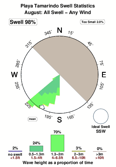
A2972°COverall Playa Tamarindo Surf Consistency and Wind Distribution in August
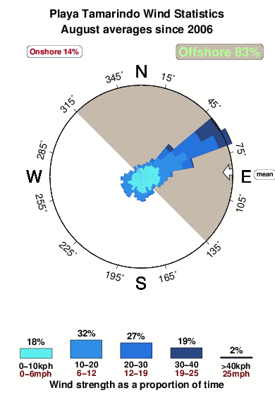


Wind stats for Playa Tamarindo: see the variation in direction and stength by month.
surffoto's uit
de galerijContourlijnen: Wegen & Rivieren: Kies een surflokatie uit het menu 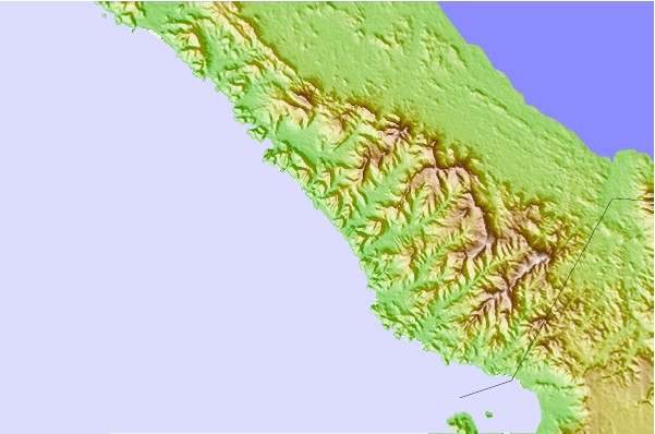
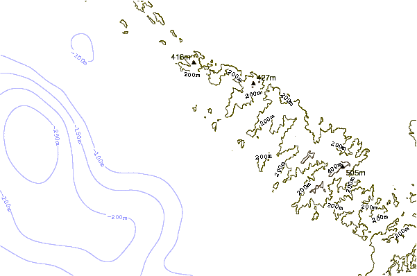
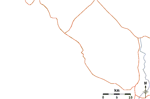
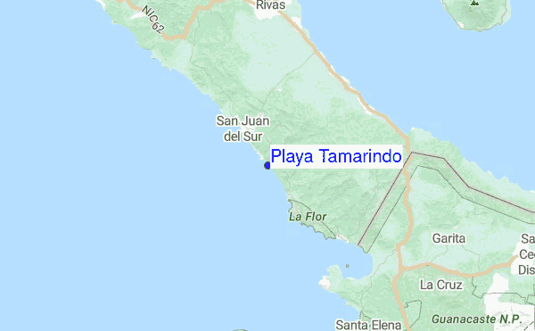
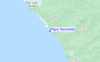
Gebruik deze reliëfkaart om naar de surfspots en de getijdenstations van Rivas Province toe te gaan, in de buurt van Playa Tamarindo.
Andere Dichtbijzijnde Surflocaties van Playa Tamarindo:
(klik op locatienaam voor meer informatie)- Closest Locatie1 mi
- Second closest Locatie1 mi
- Third closest Locatie2 mi
- Fourth closest Locatie4 mi
- Fifth closest Locatie5 mi
Dichtstbijzijnde golfboeien bij Playa Tamarindo:
- Closest golfboei485 mi
- Second closest golfboei602 mi
- Third closest golfboei925 mi
- Fourth closest golfboei1012 mi
- Fifth closest golfboei1021 mi
Getijdenstations in de buurt van Playa Tamarindo:
- Closest getijdenstationSan Juan del Sur4 mi
- Second closest getijdenstationMasachapa62 mi
- Third closest getijdenstationPunta Arenas109 mi
- Fourth closest getijdenstationChacarita110 mi
- Fifth closest getijdenstationCorinto127 mi
Airports
- The closest passenger airport to Playa Tamarindo is Daniel Oduber Quiros International (Liberia) Airport (LIR) in Costa Rica, which is 74 km (46 miles) away (directly).
- The second nearest airport to Playa Tamarindo is Managua International Airport (MGA) in Nicaragua, 111 km (69 miles) away.
- The third closest airport is Nosara Airport (NOB) in Costa Rica, 137 km (85 miles) away.
- /breaks/Playa-Tamarindo/forecasts/latest

 Nearest