

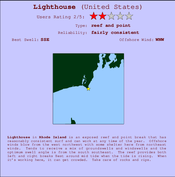
Lighthouse Surf Guide
Lighthouse in Rhode Island is an exposed reef and point break that has pretty consitent surf and can work at any time of the year. Offshore winds are from the west northwest with some shelter here from northeast winds. Waves just as likely from local windswells as from distant groundswells and the best swell direction is from the south southeast. There are left and right breaking reefs Best around mid tide when the tide is rising. Sometimes crowded. Beware of rocks and rips.
Lighthouse Spot Info
| Type: | Rating: | Reliability: | Todays Sea Temp*: |
|---|---|---|---|
| fairly consistent | 20.8°C*ocean temperature recorded from satellite |
Surfing Lighthouse:
The best conditions reported for surf at Lighthouse occur when a South-southeast swell combines with an offshore wind direction from the West-northwest.

Voorspelde Golfenergie (Kracht): 12 uur


Lighthouse Surf:
Wednesday, 15 July 2026, 07:25 Local time| Wednesday 15 | ||||
| 5AM | 8AM | 11AM | 2PM | |
| Wave (m) | ||||
| Periode (s) | 7 | 7 | 6 | 6 |
| Wind (km/h) | ||||
| Wind | cross- off |
off | off | off |
- /breaks/Point-Judithlighthouse/forecasts/latest
Lighthouse Surf Guide
Lighthouse in Rhode Island is an exposed reef and point break that has pretty consitent surf and can work at any time of the year. Offshore winds are from the west northwest with some shelter here from northeast winds. Waves just as likely from local windswells as from distant groundswells and the best swell direction is from the south southeast. There are left and right breaking reefs Best around mid tide when the tide is rising. Sometimes crowded. Beware of rocks and rips.
Lighthouse Spot Info
Type: Rating: Reliability: Todays Sea Temp*:  Reef and point
 2
2fairly consistent 20.8°C*ocean temperature recorded from satelliteSurfing Lighthouse:
The best conditions reported for surf at Lighthouse occur when a South-southeast swell combines with an offshore wind direction from the West-northwest.
Voorspelde Golfenergie (Kracht): 12 uur
Gebruik de tabbladen hierboven om de zeewatertemperatuur bij Lighthouse te bekijken, foto's van Lighthouse, Lighthouse gedetailleerde golfvoorspellingen, wind- en weersvoorspellingen, Lighthouse webcams, actuele wind in Rhode Island live weerstations en Lighthouse getijdenvoorspellingen. De link van United States golfkaarten opent een grote afbeelding van United States en de omliggende zeeën. Deze golfkaarten kunnen worden dynamisch gemaakt worden met de verschillende golfcomponenten, golfenergie, golfperiode, golfhoogte, samen met de wind en weersvoorspellingen, het actuele weer en de zeetoestand volgens golfboeien uit United States, langskomende schepen en weerstations op de kust. Elk voorspelling pagina's voor dit surfstrand zijn voorzien van een wereldwijde en regionale golfzoeker om de beste surfsomstandigheden in het gebied rond Lighthouse te vinden.
Lighthouse Surf:
Wednesday, 15 July 2026, 07:25 Local timeWednesday 15 5AM 8AM 11AM 2PM Wave (m) Periode (s) 7 7 6 6 Wind (km/h) Wind cross-
offoff off off - /breaks/Point-Judithlighthouse/forecasts/latest
- /breaks/Point-Judithlighthouse/forecasts/latest/six_day
Lighthouse Surf Guide
Lighthouse in Rhode Island is an exposed reef and point break that has pretty consitent surf and can work at any time of the year. Offshore winds are from the west northwest with some shelter here from northeast winds. Waves just as likely from local windswells as from distant groundswells and the best swell direction is from the south southeast. There are left and right breaking reefs Best around mid tide when the tide is rising. Sometimes crowded. Beware of rocks and rips.
Lighthouse Spot Info
Type: Rating: Reliability: Todays Sea Temp*: Reef and point2fairly consistent 20.8°C*ocean temperature recorded from satelliteSurfing Lighthouse:
The best conditions reported for surf at Lighthouse occur when a South-southeast swell combines with an offshore wind direction from the West-northwest.
Voorspelde Golfenergie (Kracht): 12 uur
Gebruik de tabbladen hierboven om de zeewatertemperatuur bij Lighthouse te bekijken, foto's van Lighthouse, Lighthouse gedetailleerde golfvoorspellingen, wind- en weersvoorspellingen, Lighthouse webcams, actuele wind in Rhode Island live weerstations en Lighthouse getijdenvoorspellingen. De link van United States golfkaarten opent een grote afbeelding van United States en de omliggende zeeën. Deze golfkaarten kunnen worden dynamisch gemaakt worden met de verschillende golfcomponenten, golfenergie, golfperiode, golfhoogte, samen met de wind en weersvoorspellingen, het actuele weer en de zeetoestand volgens golfboeien uit United States, langskomende schepen en weerstations op de kust. Elk voorspelling pagina's voor dit surfstrand zijn voorzien van een wereldwijde en regionale golfzoeker om de beste surfsomstandigheden in het gebied rond Lighthouse te vinden.
Lighthouse Surf:
Wednesday, 15 July 2026, 07:25 Local timeWednesday 15 5AM 8AM 11AM 2PM Wave (m) Periode (s) 7 7 6 6 Wind (km/h) Wind cross-
offoff off off - /breaks/Point-Judithlighthouse/forecasts/latest
Lighthouse Surf Guide
Lighthouse in Rhode Island is an exposed reef and point break that has pretty consitent surf and can work at any time of the year. Offshore winds are from the west northwest with some shelter here from northeast winds. Waves just as likely from local windswells as from distant groundswells and the best swell direction is from the south southeast. There are left and right breaking reefs Best around mid tide when the tide is rising. Sometimes crowded. Beware of rocks and rips.
Lighthouse Spot Info
Type: Rating: Reliability: Todays Sea Temp*: Reef and point2fairly consistent 20.8°C*ocean temperature recorded from satelliteSurfing Lighthouse:
The best conditions reported for surf at Lighthouse occur when a South-southeast swell combines with an offshore wind direction from the West-northwest.
Voorspelde Golfenergie (Kracht): 12 uur
Gebruik de tabbladen hierboven om de zeewatertemperatuur bij Lighthouse te bekijken, foto's van Lighthouse, Lighthouse gedetailleerde golfvoorspellingen, wind- en weersvoorspellingen, Lighthouse webcams, actuele wind in Rhode Island live weerstations en Lighthouse getijdenvoorspellingen. De link van United States golfkaarten opent een grote afbeelding van United States en de omliggende zeeën. Deze golfkaarten kunnen worden dynamisch gemaakt worden met de verschillende golfcomponenten, golfenergie, golfperiode, golfhoogte, samen met de wind en weersvoorspellingen, het actuele weer en de zeetoestand volgens golfboeien uit United States, langskomende schepen en weerstations op de kust. Elk voorspelling pagina's voor dit surfstrand zijn voorzien van een wereldwijde en regionale golfzoeker om de beste surfsomstandigheden in het gebied rond Lighthouse te vinden.
Lighthouse Surf:
Wednesday, 15 July 2026, 07:25 Local timeWednesday 15 5AM 8AM 11AM 2PM Wave (m) Periode (s) 7 7 6 6 Wind (km/h) Wind cross-
offoff off off Tide Times:
Voor Point Judith Harbor of Refuge, Rhode Island, %{dist} %{km} van %{location}.
VOLGENDE IS OM (lokale tijd) resterende tijd hoog water laag water Lighthouse Tide Times and Tide Chart
Live Weather:
At BUOY-NWPR1, 20 km from Lighthouse.
light winds from the SW
(km/h)Air temperature
22.5°CCurrent weather near Lighthouse
Buoy Data:
At Block Island, RI, 32 miles from Lighthouse.
1AM 2AM 3AM 4AM Gegevens Leeftijd 5 hr 4 hr 3 hr 2 hr Golfhoogte (m) 


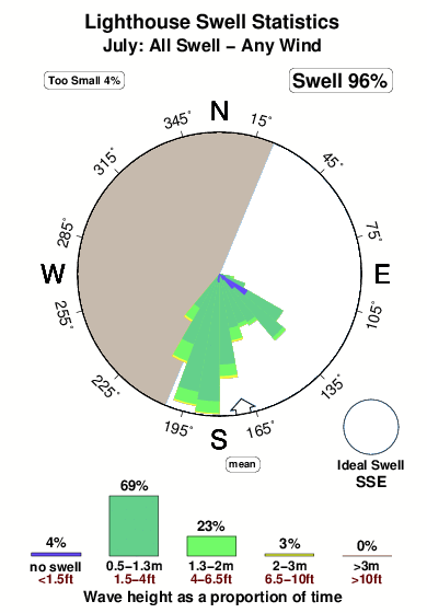
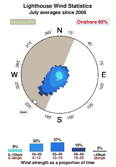
Dominante Periode (s) 7 7 7 7 Overall Lighthouse Surf Consistency and Wind Distribution in July
surffoto's uit
de galerijContourlijnen: Wegen & Rivieren: Kies een surflokatie uit het menu 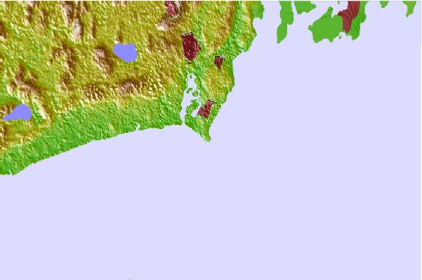

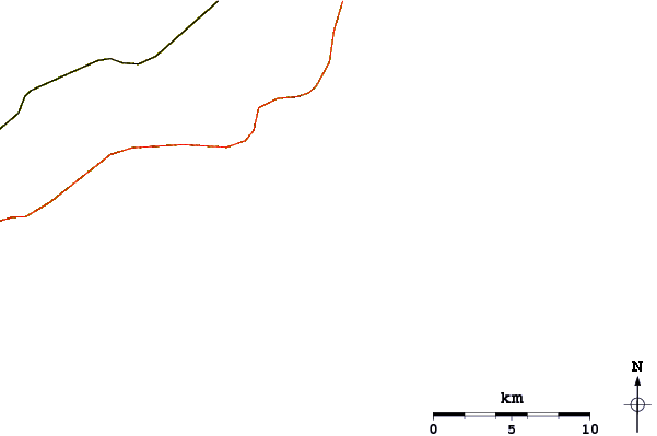
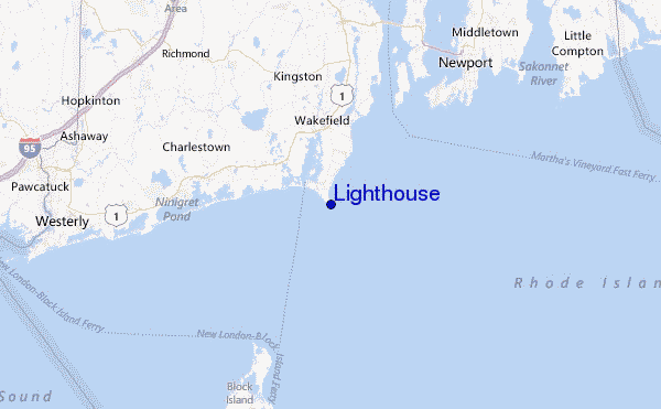
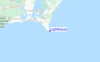
Gebruik deze reliëfkaart om naar de surfspots en de getijdenstations van Rhode Island toe te gaan, in de buurt van Lighthouse.
Andere Dichtbijzijnde Surflocaties van Lighthouse:
(klik op locatienaam voor meer informatie)- Closest Locatie0 mi
- Second closest Locatie1 mi
- Third closest Locatie1 mi
- Fourth closest Locatie2 mi
- Fifth closest Locatie3 mi
Dichtstbijzijnde golfboeien bij Lighthouse:
- Closest golfboei32 mi
- Second closest golfboei55 mi
- Third closest golfboei63 mi
- Fourth closest golfboei67 mi
- Fifth closest golfboei68 mi
Getijdenstations in de buurt van Lighthouse:
- Closest getijdenstationPoint Judith Harbor of Refuge1 mi
- Second closest getijdenstationMoonstone Beach4 mi
- Third closest getijdenstationNarragansett Pier, Narragansett Bay4 mi
- Fourth closest getijdenstationBeavertail Point, Narragansett Bay7 mi
- Fifth closest getijdenstationWatson Pier, Boston Neck, Narragansett Bay7 mi
Airports
- The closest passenger airport to Lighthouse is Theodore Francis Green State (Providence) Airport (PVD) in USA, 41 km (25 miles) away (directly).
- The second nearest airport to Lighthouse is North Central State (Smithfield) Airport (SFZ), also in USA, 62 km (39 miles) away.
- Third is Otis Angb (Falmouth) Airport (FMH) in USA, 87 km (54 miles) away.
- Hartford Brainard Airport (HFD) in USA is 106 km (66 miles) away.
- The Francis S Gabreski (West Hampton Beach) Airport (FOK), also in USA is the fifth nearest airport to Lighthouse and is 112 km (70 miles) away.
- /breaks/Point-Judithlighthouse/forecasts/latest


 Nearest