
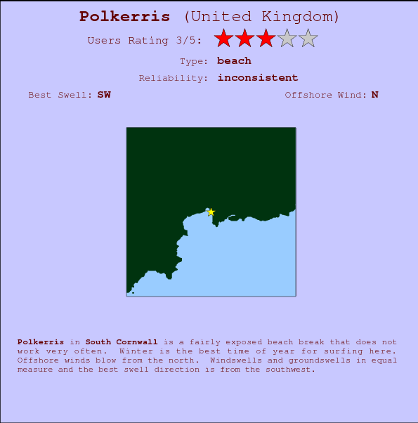
Polkerris Surf Guide
Polkerris in South Cornwall is a reasonably exposed beach break that only works once in a while. Winter is the favoured time of year for surfing here. Offshore winds are from the north. Windswells and groundswells in equal measure and the best swell direction is from the southwest..
Polkerris Spot Info
| Type: | Rating: | Reliability: | Todays Sea Temp*: |
|---|---|---|---|
| inconsistent | 19.2°C*ocean temperature recorded from satellite |
Surfing Polkerris:
The best conditions reported for surf at Polkerris occur when a Southwest swell combines with an offshore wind direction from the North.
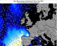
Voorspelde Golfenergie (Kracht): 12 uur


Polkerris Surf:
Sunday, 19 July 2026, 03:12 Local time| Sunday 19 | ||||
| 4AM | 7AM | 10AM | 1PM | |
| Wave (m) | ||||
| Periode (s) | 12 | 12 | 3 | 19 |
| Wind (km/h) | ||||
| Wind | cross- off |
cross- on |
cross- on |
cross- on |
- /breaks/Polkerris/forecasts/latest
Polkerris Surf Guide
Polkerris in South Cornwall is a reasonably exposed beach break that only works once in a while. Winter is the favoured time of year for surfing here. Offshore winds are from the north. Windswells and groundswells in equal measure and the best swell direction is from the southwest..
Polkerris Spot Info
Type: Rating: Reliability: Todays Sea Temp*:  Beach
Beach 3
3inconsistent 19.2°C*ocean temperature recorded from satelliteSurfing Polkerris:
The best conditions reported for surf at Polkerris occur when a Southwest swell combines with an offshore wind direction from the North.
Voorspelde Golfenergie (Kracht): 12 uur
Gebruik de tabbladen hierboven om de zeewatertemperatuur bij Polkerris te bekijken, foto's van Polkerris, Polkerris gedetailleerde golfvoorspellingen, wind- en weersvoorspellingen, Polkerris webcams, actuele wind in Cornwall (South) live weerstations en Polkerris getijdenvoorspellingen. De link van United Kingdom golfkaarten opent een grote afbeelding van United Kingdom en de omliggende zeeën. Deze golfkaarten kunnen worden dynamisch gemaakt worden met de verschillende golfcomponenten, golfenergie, golfperiode, golfhoogte, samen met de wind en weersvoorspellingen, het actuele weer en de zeetoestand volgens golfboeien uit United Kingdom, langskomende schepen en weerstations op de kust. Elk voorspelling pagina's voor dit surfstrand zijn voorzien van een wereldwijde en regionale golfzoeker om de beste surfsomstandigheden in het gebied rond Polkerris te vinden.
Polkerris Surf:
Sunday, 19 July 2026, 03:12 Local timeSunday 19 4AM 7AM 10AM 1PM Wave (m) Periode (s) 12 12 3 19 Wind (km/h) Wind cross-
offcross-
oncross-
oncross-
on- /breaks/Polkerris/forecasts/latest
- /breaks/Polkerris/forecasts/latest/six_day
Polkerris Surf Guide
Polkerris in South Cornwall is a reasonably exposed beach break that only works once in a while. Winter is the favoured time of year for surfing here. Offshore winds are from the north. Windswells and groundswells in equal measure and the best swell direction is from the southwest..
Polkerris Spot Info
Type: Rating: Reliability: Todays Sea Temp*: Beach3inconsistent 19.2°C*ocean temperature recorded from satelliteSurfing Polkerris:
The best conditions reported for surf at Polkerris occur when a Southwest swell combines with an offshore wind direction from the North.
Voorspelde Golfenergie (Kracht): 12 uur
Gebruik de tabbladen hierboven om de zeewatertemperatuur bij Polkerris te bekijken, foto's van Polkerris, Polkerris gedetailleerde golfvoorspellingen, wind- en weersvoorspellingen, Polkerris webcams, actuele wind in Cornwall (South) live weerstations en Polkerris getijdenvoorspellingen. De link van United Kingdom golfkaarten opent een grote afbeelding van United Kingdom en de omliggende zeeën. Deze golfkaarten kunnen worden dynamisch gemaakt worden met de verschillende golfcomponenten, golfenergie, golfperiode, golfhoogte, samen met de wind en weersvoorspellingen, het actuele weer en de zeetoestand volgens golfboeien uit United Kingdom, langskomende schepen en weerstations op de kust. Elk voorspelling pagina's voor dit surfstrand zijn voorzien van een wereldwijde en regionale golfzoeker om de beste surfsomstandigheden in het gebied rond Polkerris te vinden.
Polkerris Surf:
Sunday, 19 July 2026, 03:12 Local timeSunday 19 4AM 7AM 10AM 1PM Wave (m) Periode (s) 12 12 3 19 Wind (km/h) Wind cross-
offcross-
oncross-
oncross-
on- /breaks/Polkerris/forecasts/latest
Polkerris Surf Guide
Polkerris in South Cornwall is a reasonably exposed beach break that only works once in a while. Winter is the favoured time of year for surfing here. Offshore winds are from the north. Windswells and groundswells in equal measure and the best swell direction is from the southwest..
Polkerris Spot Info
Type: Rating: Reliability: Todays Sea Temp*: Beach3inconsistent 19.2°C*ocean temperature recorded from satelliteSurfing Polkerris:
The best conditions reported for surf at Polkerris occur when a Southwest swell combines with an offshore wind direction from the North.
Voorspelde Golfenergie (Kracht): 12 uur
Gebruik de tabbladen hierboven om de zeewatertemperatuur bij Polkerris te bekijken, foto's van Polkerris, Polkerris gedetailleerde golfvoorspellingen, wind- en weersvoorspellingen, Polkerris webcams, actuele wind in Cornwall (South) live weerstations en Polkerris getijdenvoorspellingen. De link van United Kingdom golfkaarten opent een grote afbeelding van United Kingdom en de omliggende zeeën. Deze golfkaarten kunnen worden dynamisch gemaakt worden met de verschillende golfcomponenten, golfenergie, golfperiode, golfhoogte, samen met de wind en weersvoorspellingen, het actuele weer en de zeetoestand volgens golfboeien uit United Kingdom, langskomende schepen en weerstations op de kust. Elk voorspelling pagina's voor dit surfstrand zijn voorzien van een wereldwijde en regionale golfzoeker om de beste surfsomstandigheden in het gebied rond Polkerris te vinden.
Polkerris Surf:
Sunday, 19 July 2026, 03:12 Local timeSunday 19 4AM 7AM 10AM 1PM Wave (m) Periode (s) 12 12 3 19 Wind (km/h) Wind cross-
offcross-
oncross-
oncross-
onTide Times:
Voor Par, %{dist} %{km} van %{location}.
VOLGENDE IS OM (lokale tijd) resterende tijd hoog water laag water Polkerris Tide Times and Tide Chart
Live Weather:
At Newquay Airport, 24 km from Polkerris.
light winds from the N.(Wind varies from 340 to 040 degs)
(km/h)
Dry and partly cloudyAir temperature
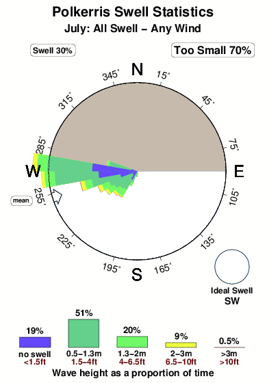
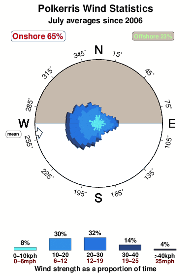
16°COverall Polkerris Surf Consistency and Wind Distribution in July
surffoto's uit
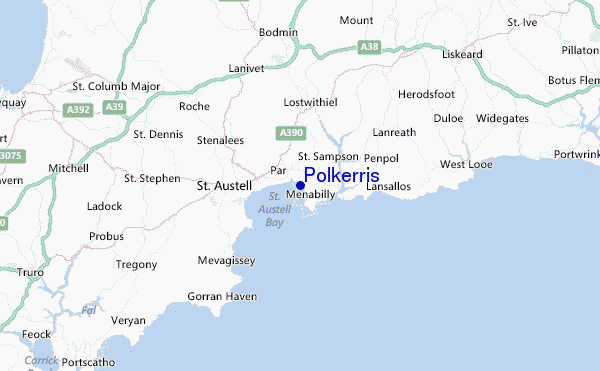
de galerijContourlijnen: Wegen & Rivieren: Kies een surflokatie uit het menu 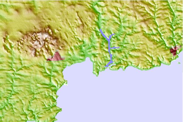

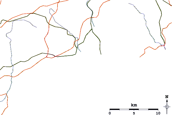
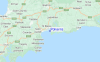
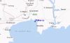
Gebruik deze reliëfkaart om naar de surfspots en de getijdenstations van Cornwall (South) toe te gaan, in de buurt van Polkerris.
Andere Dichtbijzijnde Surflocaties van Polkerris:
(klik op locatienaam voor meer informatie)- Closest Locatie6 mi
- Second closest Locatie10 mi
- Third closest Locatie11 mi
- Fourth closest Locatie11 mi
- Fifth closest Locatie13 mi
Dichtstbijzijnde golfboeien bij Polkerris:
- Closest golfboei12 mi
- Second closest golfboei21 mi
- Third closest golfboei27 mi
- Fourth closest golfboei34 mi
- Fifth closest golfboei40 mi
Getijdenstations in de buurt van Polkerris:
- Closest getijdenstationPar1 mi
- Second closest getijdenstationSaint Austell3 mi
- Third closest getijdenstationLooe11 mi
- Fourth closest getijdenstationWadebridge14 mi
- Fifth closest getijdenstationTruro17 mi
Airports
- The closest passenger airport to Polkerris is St Mawgan (Newquai) Airport (NQY) in England, 25 km (16 miles) away (directly).
- The second nearest airport to Polkerris is Plymouth Airport (PLH), also in England, 43 km (27 miles) away.
- Third is Exeter Airport (EXT) in England, 100 km (62 miles) away.
- Swansea Airport (SWS) in Wales is 148 km (92 miles) away.
- Cardiff Airport (CWL), also in Wales is the fifth nearest airport to Polkerris and is 151 km (94 miles) away.
- /breaks/Polkerris/forecasts/latest


 Nearest