
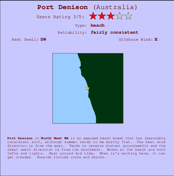
Port Denison Surf Guide
Port Denison in North West is an exposed beach break that has quite reliable surf, although summer tends to be mostly flat. Works best in offshore winds from the east. Clean groundswells prevail and the ideal swell direction is from the southwest. Waves at the beach break both left and right. Best around mid tide. It's sometimes crowded here. Hazards include rocks and sharks.
Port Denison Spot Info
| Type: | Rating: | Reliability: | Todays Sea Temp*: |
|---|---|---|---|
| fairly consistent | 19.7°C*ocean temperature recorded from satellite |
Surfing Port Denison:
The best conditions reported for surf at Port Denison occur when a Southwest swell combines with an offshore wind direction from the East.
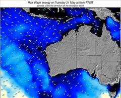
Voorspelde Golfenergie (Kracht): 12 uur

Port Denison Surf:
Thursday, 16 July 2026, 00:39 Local time| Wed | Thursday 16 | |||
| 11PM | 2AM | 5AM | 8AM | |
| Wave (m) | ||||
| Periode (s) | 16 | 16 | 16 | 15 |
| Wind (km/h) | ||||
| Wind | cross- off |
cross- off |
cross- off |
cross- off |
- /breaks/Port-Denison/forecasts/latest
Port Denison Surf Guide
Port Denison in North West is an exposed beach break that has quite reliable surf, although summer tends to be mostly flat. Works best in offshore winds from the east. Clean groundswells prevail and the ideal swell direction is from the southwest. Waves at the beach break both left and right. Best around mid tide. It's sometimes crowded here. Hazards include rocks and sharks.
Port Denison Spot Info
Type: Rating: Reliability: Todays Sea Temp*:  Beach
Beach 3
3fairly consistent 19.7°C*ocean temperature recorded from satelliteSurfing Port Denison:
The best conditions reported for surf at Port Denison occur when a Southwest swell combines with an offshore wind direction from the East.
Voorspelde Golfenergie (Kracht): 12 uur
Gebruik de tabbladen hierboven om de zeewatertemperatuur bij Port Denison te bekijken, foto's van Port Denison, Port Denison gedetailleerde golfvoorspellingen, wind- en weersvoorspellingen, Port Denison webcams, actuele wind in WA - North West live weerstations en Port Denison getijdenvoorspellingen. De link van Australia golfkaarten opent een grote afbeelding van Australia en de omliggende zeeën. Deze golfkaarten kunnen worden dynamisch gemaakt worden met de verschillende golfcomponenten, golfenergie, golfperiode, golfhoogte, samen met de wind en weersvoorspellingen, het actuele weer en de zeetoestand volgens golfboeien uit Australia, langskomende schepen en weerstations op de kust. Elk voorspelling pagina's voor dit surfstrand zijn voorzien van een wereldwijde en regionale golfzoeker om de beste surfsomstandigheden in het gebied rond Port Denison te vinden.
Port Denison Surf:
Thursday, 16 July 2026, 00:39 Local timeWed Thursday 16 11PM 2AM 5AM 8AM Wave (m) Periode (s) 16 16 16 15 Wind (km/h) Wind cross-
offcross-
offcross-
offcross-
off- /breaks/Port-Denison/forecasts/latest
- /breaks/Port-Denison/forecasts/latest/six_day
Port Denison Surf Guide
Port Denison in North West is an exposed beach break that has quite reliable surf, although summer tends to be mostly flat. Works best in offshore winds from the east. Clean groundswells prevail and the ideal swell direction is from the southwest. Waves at the beach break both left and right. Best around mid tide. It's sometimes crowded here. Hazards include rocks and sharks.
Port Denison Spot Info
Type: Rating: Reliability: Todays Sea Temp*: Beach3fairly consistent 19.7°C*ocean temperature recorded from satelliteSurfing Port Denison:
The best conditions reported for surf at Port Denison occur when a Southwest swell combines with an offshore wind direction from the East.
Voorspelde Golfenergie (Kracht): 12 uur
Gebruik de tabbladen hierboven om de zeewatertemperatuur bij Port Denison te bekijken, foto's van Port Denison, Port Denison gedetailleerde golfvoorspellingen, wind- en weersvoorspellingen, Port Denison webcams, actuele wind in WA - North West live weerstations en Port Denison getijdenvoorspellingen. De link van Australia golfkaarten opent een grote afbeelding van Australia en de omliggende zeeën. Deze golfkaarten kunnen worden dynamisch gemaakt worden met de verschillende golfcomponenten, golfenergie, golfperiode, golfhoogte, samen met de wind en weersvoorspellingen, het actuele weer en de zeetoestand volgens golfboeien uit Australia, langskomende schepen en weerstations op de kust. Elk voorspelling pagina's voor dit surfstrand zijn voorzien van een wereldwijde en regionale golfzoeker om de beste surfsomstandigheden in het gebied rond Port Denison te vinden.
Port Denison Surf:
Thursday, 16 July 2026, 00:39 Local timeWed Thursday 16 11PM 2AM 5AM 8AM Wave (m) Periode (s) 16 16 16 15 Wind (km/h) Wind cross-
offcross-
offcross-
offcross-
off- /breaks/Port-Denison/forecasts/latest
Port Denison Surf Guide
Port Denison in North West is an exposed beach break that has quite reliable surf, although summer tends to be mostly flat. Works best in offshore winds from the east. Clean groundswells prevail and the ideal swell direction is from the southwest. Waves at the beach break both left and right. Best around mid tide. It's sometimes crowded here. Hazards include rocks and sharks.
Port Denison Spot Info
Type: Rating: Reliability: Todays Sea Temp*: Beach3fairly consistent 19.7°C*ocean temperature recorded from satelliteSurfing Port Denison:
The best conditions reported for surf at Port Denison occur when a Southwest swell combines with an offshore wind direction from the East.
Voorspelde Golfenergie (Kracht): 12 uur
Gebruik de tabbladen hierboven om de zeewatertemperatuur bij Port Denison te bekijken, foto's van Port Denison, Port Denison gedetailleerde golfvoorspellingen, wind- en weersvoorspellingen, Port Denison webcams, actuele wind in WA - North West live weerstations en Port Denison getijdenvoorspellingen. De link van Australia golfkaarten opent een grote afbeelding van Australia en de omliggende zeeën. Deze golfkaarten kunnen worden dynamisch gemaakt worden met de verschillende golfcomponenten, golfenergie, golfperiode, golfhoogte, samen met de wind en weersvoorspellingen, het actuele weer en de zeetoestand volgens golfboeien uit Australia, langskomende schepen en weerstations op de kust. Elk voorspelling pagina's voor dit surfstrand zijn voorzien van een wereldwijde en regionale golfzoeker om de beste surfsomstandigheden in het gebied rond Port Denison te vinden.
Port Denison Surf:
Thursday, 16 July 2026, 00:39 Local timeWed Thursday 16 11PM 2AM 5AM 8AM Wave (m) Periode (s) 16 16 16 15 Wind (km/h) Wind cross-
offcross-
offcross-
offcross-
offTide Times:
Op Port Denison (0 km).
VOLGENDE IS OM (lokale tijd) resterende tijd hoog water laag water Port Denison Tide Times and Tide Chart
Live Weather:
At ASCATC115E30S, 52 km from Port Denison.
light winds from the NNE
(km/h)Air temperature
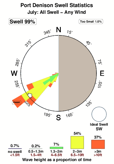
-°COverall Port Denison Surf Consistency and Wind Distribution in July
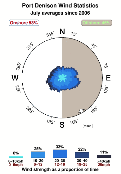


Wind stats for Port Denison: see the variation in direction and stength by month.
surffoto's uit
de galerijContourlijnen: Wegen & Rivieren: Kies een surflokatie uit het menu 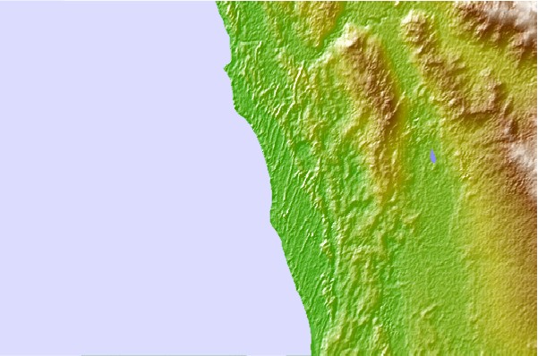

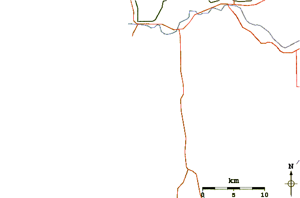
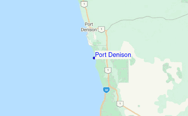
Gebruik deze reliëfkaart om naar de surfspots en de getijdenstations van WA - North West toe te gaan, in de buurt van Port Denison.
Andere Dichtbijzijnde Surflocaties van Port Denison:
(klik op locatienaam voor meer informatie)- Closest Locatie7 mi
- Second closest Locatie26 mi
- Third closest Locatie30 mi
- Fourth closest Locatie40 mi
- Fifth closest Locatie44 mi
Dichtstbijzijnde golfboeien bij Port Denison:
- Closest golfboei1339 mi
- Second closest golfboei1891 mi
- Third closest golfboei2066 mi
- Fourth closest golfboei2095 mi
- Fifth closest golfboei2098 mi
Getijdenstations in de buurt van Port Denison:
- Closest getijdenstationGeraldton46 mi
- Second closest getijdenstationJurien Bay65 mi
- Third closest getijdenstationCervantes79 mi
- Fourth closest getijdenstationEaster Group84 mi
- Fifth closest getijdenstationPort Gregory91 mi
Airports
- The nearest passenger airport to Port Denison is Perth International Airport (PER) in Australia, which is 302 km (188 miles) away (directly).
- The second closest airport to Port Denison is Perth Jandakot Airport (JAD), also in Australia, 317 km (197 miles) away.
- /breaks/Port-Denison/forecasts/latest
 Nearest