
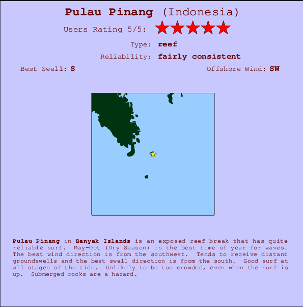
Pulau Pinang Surf Guide
Pulau Pinang in Banyak Islands is an exposed reef break that has quite reliable surf. May-Oct (Dry Season) is the best time of year for waves. Works best in offshore winds from the southwest. Groundswells more frequent than windswells and the best swell direction is from the south. A reef breaks right. Surfable at all stages of the tide. It very rarely gets crowded here. Watch out for rocks.
Pulau Pinang Spot Info
| Type: | Rating: | Reliability: | Todays Sea Temp*: |
|---|---|---|---|
| fairly consistent | 30.0°C*ocean temperature recorded from satellite |
Surfing Pulau Pinang:
The best conditions reported for surf at Pulau Pinang occur when a South swell combines with an offshore wind direction from the Southwest.

Voorspelde Golfenergie (Kracht): 12 uur


Pulau Pinang Surf:
Saturday, 18 July 2026, 17:10 Local time| Saturday 18 | Sun | |||
| 4PM | 7PM | 10PM | 1AM | |
| Wave (m) | ||||
| Periode (s) | 14 | 14 | 14 | 14 |
| Wind (km/h) | ||||
| Wind | cross- off |
cross- off |
cross- on |
on |
- /breaks/Pulau-Pinang/forecasts/latest
Pulau Pinang Surf Guide
Pulau Pinang in Banyak Islands is an exposed reef break that has quite reliable surf. May-Oct (Dry Season) is the best time of year for waves. Works best in offshore winds from the southwest. Groundswells more frequent than windswells and the best swell direction is from the south. A reef breaks right. Surfable at all stages of the tide. It very rarely gets crowded here. Watch out for rocks.
Pulau Pinang Spot Info
Type: Rating: Reliability: Todays Sea Temp*:  Reef
Reef 5
5fairly consistent 30.0°C*ocean temperature recorded from satelliteSurfing Pulau Pinang:
The best conditions reported for surf at Pulau Pinang occur when a South swell combines with an offshore wind direction from the Southwest.
Voorspelde Golfenergie (Kracht): 12 uur
Gebruik de tabbladen hierboven om de zeewatertemperatuur bij Pulau Pinang te bekijken, foto's van Pulau Pinang, Pulau Pinang gedetailleerde golfvoorspellingen, wind- en weersvoorspellingen, Pulau Pinang webcams, actuele wind in Banyak Islands live weerstations en Pulau Pinang getijdenvoorspellingen. De link van Indonesia golfkaarten opent een grote afbeelding van Indonesia en de omliggende zeeën. Deze golfkaarten kunnen worden dynamisch gemaakt worden met de verschillende golfcomponenten, golfenergie, golfperiode, golfhoogte, samen met de wind en weersvoorspellingen, het actuele weer en de zeetoestand volgens golfboeien uit Indonesia, langskomende schepen en weerstations op de kust. Elk voorspelling pagina's voor dit surfstrand zijn voorzien van een wereldwijde en regionale golfzoeker om de beste surfsomstandigheden in het gebied rond Pulau Pinang te vinden.
Pulau Pinang Surf:
Saturday, 18 July 2026, 17:10 Local timeSaturday 18 Sun 4PM 7PM 10PM 1AM Wave (m) Periode (s) 14 14 14 14 Wind (km/h) Wind cross-
offcross-
offcross-
onon - /breaks/Pulau-Pinang/forecasts/latest
- /breaks/Pulau-Pinang/forecasts/latest/six_day
Pulau Pinang Surf Guide
Pulau Pinang in Banyak Islands is an exposed reef break that has quite reliable surf. May-Oct (Dry Season) is the best time of year for waves. Works best in offshore winds from the southwest. Groundswells more frequent than windswells and the best swell direction is from the south. A reef breaks right. Surfable at all stages of the tide. It very rarely gets crowded here. Watch out for rocks.
Pulau Pinang Spot Info
Type: Rating: Reliability: Todays Sea Temp*: Reef5fairly consistent 30.0°C*ocean temperature recorded from satelliteSurfing Pulau Pinang:
The best conditions reported for surf at Pulau Pinang occur when a South swell combines with an offshore wind direction from the Southwest.
Voorspelde Golfenergie (Kracht): 12 uur
Gebruik de tabbladen hierboven om de zeewatertemperatuur bij Pulau Pinang te bekijken, foto's van Pulau Pinang, Pulau Pinang gedetailleerde golfvoorspellingen, wind- en weersvoorspellingen, Pulau Pinang webcams, actuele wind in Banyak Islands live weerstations en Pulau Pinang getijdenvoorspellingen. De link van Indonesia golfkaarten opent een grote afbeelding van Indonesia en de omliggende zeeën. Deze golfkaarten kunnen worden dynamisch gemaakt worden met de verschillende golfcomponenten, golfenergie, golfperiode, golfhoogte, samen met de wind en weersvoorspellingen, het actuele weer en de zeetoestand volgens golfboeien uit Indonesia, langskomende schepen en weerstations op de kust. Elk voorspelling pagina's voor dit surfstrand zijn voorzien van een wereldwijde en regionale golfzoeker om de beste surfsomstandigheden in het gebied rond Pulau Pinang te vinden.
Pulau Pinang Surf:
Saturday, 18 July 2026, 17:10 Local timeSaturday 18 Sun 4PM 7PM 10PM 1AM Wave (m) Periode (s) 14 14 14 14 Wind (km/h) Wind cross-
offcross-
offcross-
onon - /breaks/Pulau-Pinang/forecasts/latest
Pulau Pinang Surf Guide
Pulau Pinang in Banyak Islands is an exposed reef break that has quite reliable surf. May-Oct (Dry Season) is the best time of year for waves. Works best in offshore winds from the southwest. Groundswells more frequent than windswells and the best swell direction is from the south. A reef breaks right. Surfable at all stages of the tide. It very rarely gets crowded here. Watch out for rocks.
Pulau Pinang Spot Info
Type: Rating: Reliability: Todays Sea Temp*: Reef5fairly consistent 30.0°C*ocean temperature recorded from satelliteSurfing Pulau Pinang:
The best conditions reported for surf at Pulau Pinang occur when a South swell combines with an offshore wind direction from the Southwest.
Voorspelde Golfenergie (Kracht): 12 uur
Gebruik de tabbladen hierboven om de zeewatertemperatuur bij Pulau Pinang te bekijken, foto's van Pulau Pinang, Pulau Pinang gedetailleerde golfvoorspellingen, wind- en weersvoorspellingen, Pulau Pinang webcams, actuele wind in Banyak Islands live weerstations en Pulau Pinang getijdenvoorspellingen. De link van Indonesia golfkaarten opent een grote afbeelding van Indonesia en de omliggende zeeën. Deze golfkaarten kunnen worden dynamisch gemaakt worden met de verschillende golfcomponenten, golfenergie, golfperiode, golfhoogte, samen met de wind en weersvoorspellingen, het actuele weer en de zeetoestand volgens golfboeien uit Indonesia, langskomende schepen en weerstations op de kust. Elk voorspelling pagina's voor dit surfstrand zijn voorzien van een wereldwijde en regionale golfzoeker om de beste surfsomstandigheden in het gebied rond Pulau Pinang te vinden.
Pulau Pinang Surf:
Saturday, 18 July 2026, 17:10 Local timeSaturday 18 Sun 4PM 7PM 10PM 1AM Wave (m) Periode (s) 14 14 14 14 Wind (km/h) Wind cross-
offcross-
offcross-
onon Tide Times:
Voor Bay of Plenty, %{dist} %{km} van %{location}.
VOLGENDE IS OM (lokale tijd) resterende tijd hoog water laag water Pulau Pinang Tide Times and Tide Chart
Live Weather:
At Medan/Polonia Airport, 221 km from Pulau Pinang.
light winds from the W
(km/h)
Dry and partly cloudyAir temperature
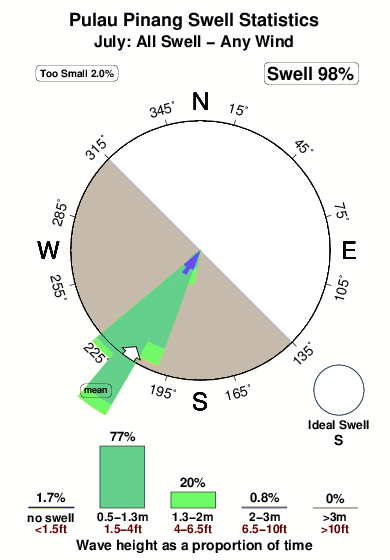
27°COverall Pulau Pinang Surf Consistency and Wind Distribution in July
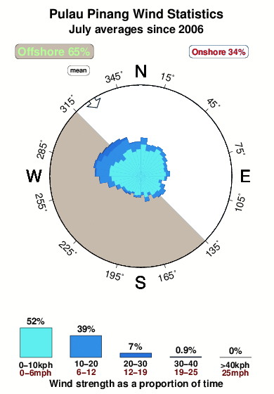


Wind stats for Pulau Pinang: see the variation in direction and stength by month.
surffoto's uit
de galerijContourlijnen: Wegen & Rivieren: Kies een surflokatie uit het menu 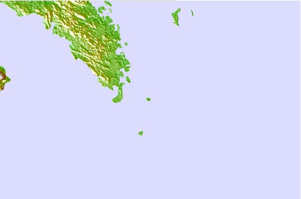
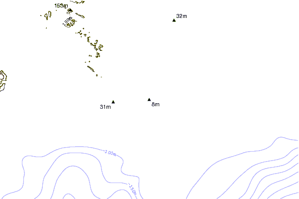

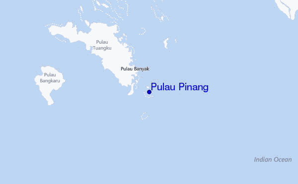
Gebruik deze reliëfkaart om naar de surfspots en de getijdenstations van Banyak Islands toe te gaan, in de buurt van Pulau Pinang.
Andere Dichtbijzijnde Surflocaties van Pulau Pinang:
(klik op locatienaam voor meer informatie)- Closest Locatie4 mi
- Second closest Locatie7 mi
- Third closest Locatie21 mi
- Fourth closest Locatie77 mi
- Fifth closest Locatie78 mi
Dichtstbijzijnde golfboeien bij Pulau Pinang:
- Closest golfboei2359 mi
- Second closest golfboei2437 mi
- Third closest golfboei2616 mi
- Fourth closest golfboei2631 mi
- Fifth closest golfboei2797 mi
Getijdenstations in de buurt van Pulau Pinang:
- Closest getijdenstationSinabang76 mi
- Second closest getijdenstationSibolga98 mi
- Third closest getijdenstationPangkalan Brandan150 mi
- Fourth closest getijdenstationBelawan154 mi
- Fifth closest getijdenstationTanjungtiram155 mi
Airports
- The nearest passenger airport to Pulau Pinang is Binaka (Gunung Sitoli) Airport (GNS) in Indonesia, which is 103 km (64 miles) away (directly).
- The second closest airport to Pulau Pinang is Polonia (Medan) Airport (MES), also in Indonesia, 221 km (137 miles) away.
- /breaks/Pulau-Pinang/forecasts/latest
 Nearest