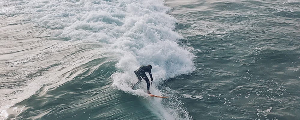
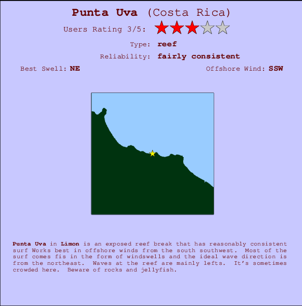
Punta Uva Surf Guide
Punta Uva in Limon is an exposed beach break that has reasonably consistent surf Offshore winds blow from the south southwest. Usually gets local windswells, but groundswells do happen and the ideal wave angle is from the northeast. The beach breaks offer lefts and rights. When the surf is up, it can get quite busy in the water. Beware of rocks and jellyfish.
Punta Uva Spot Info
| Type: | Rating: | Reliability: | Todays Sea Temp*: |
|---|---|---|---|
| fairly consistent | 29.0°C*ocean temperature recorded from satellite |
Surfing Punta Uva:
The best conditions reported for surf at Punta Uva occur when a Northeast swell combines with an offshore wind direction from the South-southwest.

Voorspelde Golfenergie (Kracht): 12 uur


Punta Uva Surf:
Wednesday, 15 July 2026, 06:25 Local time| Wednesday 15 | ||||
| 4AM | 7AM | 10AM | 1PM | |
| Wave (m) | ||||
| Periode (s) | 9 | 9 | 9 | 9 |
| Wind (km/h) | ||||
| Wind | cross | cross | cross- on |
cross- on |
- /breaks/Punta-Uva/forecasts/latest
Punta Uva Surf Guide
Punta Uva in Limon is an exposed beach break that has reasonably consistent surf Offshore winds blow from the south southwest. Usually gets local windswells, but groundswells do happen and the ideal wave angle is from the northeast. The beach breaks offer lefts and rights. When the surf is up, it can get quite busy in the water. Beware of rocks and jellyfish.
Punta Uva Spot Info
Type: Rating: Reliability: Todays Sea Temp*:  Reef
Reef 3
3fairly consistent 29.0°C*ocean temperature recorded from satelliteSurfing Punta Uva:
The best conditions reported for surf at Punta Uva occur when a Northeast swell combines with an offshore wind direction from the South-southwest.
Voorspelde Golfenergie (Kracht): 12 uur
Gebruik de tabbladen hierboven om de zeewatertemperatuur bij Punta Uva te bekijken, foto's van Punta Uva, Punta Uva gedetailleerde golfvoorspellingen, wind- en weersvoorspellingen, Punta Uva webcams, actuele wind in Limon live weerstations en Punta Uva getijdenvoorspellingen. De link van Costa Rica golfkaarten opent een grote afbeelding van Costa Rica en de omliggende zeeën. Deze golfkaarten kunnen worden dynamisch gemaakt worden met de verschillende golfcomponenten, golfenergie, golfperiode, golfhoogte, samen met de wind en weersvoorspellingen, het actuele weer en de zeetoestand volgens golfboeien uit Costa Rica, langskomende schepen en weerstations op de kust. Elk voorspelling pagina's voor dit surfstrand zijn voorzien van een wereldwijde en regionale golfzoeker om de beste surfsomstandigheden in het gebied rond Punta Uva te vinden.
Punta Uva Surf:
Wednesday, 15 July 2026, 06:25 Local timeWednesday 15 4AM 7AM 10AM 1PM Wave (m) Periode (s) 9 9 9 9 Wind (km/h) Wind cross cross cross-
oncross-
on- /breaks/Punta-Uva/forecasts/latest
- /breaks/Punta-Uva/forecasts/latest/six_day
Punta Uva Surf Guide
Punta Uva in Limon is an exposed beach break that has reasonably consistent surf Offshore winds blow from the south southwest. Usually gets local windswells, but groundswells do happen and the ideal wave angle is from the northeast. The beach breaks offer lefts and rights. When the surf is up, it can get quite busy in the water. Beware of rocks and jellyfish.
Punta Uva Spot Info
Type: Rating: Reliability: Todays Sea Temp*: Reef3fairly consistent 29.0°C*ocean temperature recorded from satelliteSurfing Punta Uva:
The best conditions reported for surf at Punta Uva occur when a Northeast swell combines with an offshore wind direction from the South-southwest.
Voorspelde Golfenergie (Kracht): 12 uur
Gebruik de tabbladen hierboven om de zeewatertemperatuur bij Punta Uva te bekijken, foto's van Punta Uva, Punta Uva gedetailleerde golfvoorspellingen, wind- en weersvoorspellingen, Punta Uva webcams, actuele wind in Limon live weerstations en Punta Uva getijdenvoorspellingen. De link van Costa Rica golfkaarten opent een grote afbeelding van Costa Rica en de omliggende zeeën. Deze golfkaarten kunnen worden dynamisch gemaakt worden met de verschillende golfcomponenten, golfenergie, golfperiode, golfhoogte, samen met de wind en weersvoorspellingen, het actuele weer en de zeetoestand volgens golfboeien uit Costa Rica, langskomende schepen en weerstations op de kust. Elk voorspelling pagina's voor dit surfstrand zijn voorzien van een wereldwijde en regionale golfzoeker om de beste surfsomstandigheden in het gebied rond Punta Uva te vinden.
Punta Uva Surf:
Wednesday, 15 July 2026, 06:25 Local timeWednesday 15 4AM 7AM 10AM 1PM Wave (m) Periode (s) 9 9 9 9 Wind (km/h) Wind cross cross cross-
oncross-
on- /breaks/Punta-Uva/forecasts/latest
Punta Uva Surf Guide
Punta Uva in Limon is an exposed beach break that has reasonably consistent surf Offshore winds blow from the south southwest. Usually gets local windswells, but groundswells do happen and the ideal wave angle is from the northeast. The beach breaks offer lefts and rights. When the surf is up, it can get quite busy in the water. Beware of rocks and jellyfish.
Punta Uva Spot Info
Type: Rating: Reliability: Todays Sea Temp*: Reef3fairly consistent 29.0°C*ocean temperature recorded from satelliteSurfing Punta Uva:
The best conditions reported for surf at Punta Uva occur when a Northeast swell combines with an offshore wind direction from the South-southwest.
Voorspelde Golfenergie (Kracht): 12 uur
Gebruik de tabbladen hierboven om de zeewatertemperatuur bij Punta Uva te bekijken, foto's van Punta Uva, Punta Uva gedetailleerde golfvoorspellingen, wind- en weersvoorspellingen, Punta Uva webcams, actuele wind in Limon live weerstations en Punta Uva getijdenvoorspellingen. De link van Costa Rica golfkaarten opent een grote afbeelding van Costa Rica en de omliggende zeeën. Deze golfkaarten kunnen worden dynamisch gemaakt worden met de verschillende golfcomponenten, golfenergie, golfperiode, golfhoogte, samen met de wind en weersvoorspellingen, het actuele weer en de zeetoestand volgens golfboeien uit Costa Rica, langskomende schepen en weerstations op de kust. Elk voorspelling pagina's voor dit surfstrand zijn voorzien van een wereldwijde en regionale golfzoeker om de beste surfsomstandigheden in het gebied rond Punta Uva te vinden.
Punta Uva Surf:
Wednesday, 15 July 2026, 06:25 Local timeWednesday 15 4AM 7AM 10AM 1PM Wave (m) Periode (s) 9 9 9 9 Wind (km/h) Wind cross cross cross-
oncross-
onTide Times:
Voor Manzanillo, %{dist} %{km} van %{location}.
VOLGENDE IS OM (lokale tijd) resterende tijd hoog water laag water Punta Uva Tide Times and Tide Chart
Live Weather:
At Cahuita wx, 22 km from Punta Uva.
-
dryAir temperature
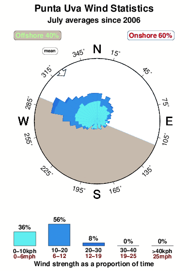
25°COverall Punta Uva Surf Consistency and Wind Distribution in July
surffoto's uit
de galerijContourlijnen: Wegen & Rivieren: Kies een surflokatie uit het menu 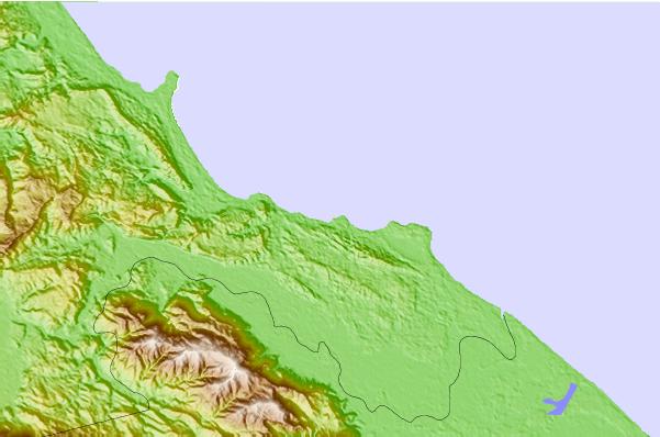
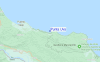
Gebruik deze reliëfkaart om naar de surfspots en de getijdenstations van Limon toe te gaan, in de buurt van Punta Uva.
Andere Dichtbijzijnde Surflocaties van Punta Uva:
(klik op locatienaam voor meer informatie)- Closest Locatie2 mi
- Second closest Locatie2 mi
- Third closest Locatie3 mi
- Fourth closest Locatie4 mi
- Fifth closest Locatie7 mi
Dichtstbijzijnde golfboeien bij Punta Uva:
- Closest golfboei503 mi
- Second closest golfboei725 mi
- Third closest golfboei1112 mi
- Fourth closest golfboei1140 mi
- Fifth closest golfboei1145 mi
Getijdenstations in de buurt van Punta Uva:
- Closest getijdenstationAlmirante31 mi
- Second closest getijdenstationLimon34 mi
- Third closest getijdenstationBocas del Toro, Almirante Bay37 mi
- Fourth closest getijdenstationGolfito76 mi
- Fifth closest getijdenstationPedregal90 mi
Airports
- The closest passenger airport to Punta Uva is Cap Manuel Nino International (Changuinola) Airport (CHX) in Panama, 28 km (17 miles) away (directly).
- The second nearest airport to Punta Uva is Limon International Airport (LIO) in Costa Rica, 50 km (31 miles) away.
- Third is Bocas Del Toro Airport (BOC) in Panama, 59 km (37 miles) away.
- Palmar Sur Airport (PMZ) in Costa Rica is 114 km (71 miles) away.
- Coto 47 Airport (OTR), also in Costa Rica is the fifth nearest airport to Punta Uva and is 119 km (74 miles) away.
- /breaks/Punta-Uva/forecasts/latest


 Nearest