

Raglan-Indicators Surf Guide
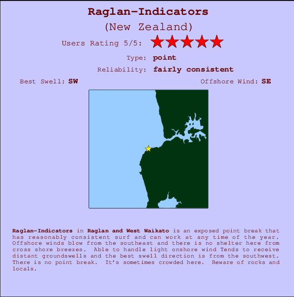
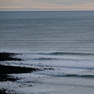
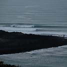
Raglan-Indicators in West Coast Auckland is an exposed point break that has reasonably consistent surf and can work at any time of the year. Offshore winds are from the southeast. Waves can be ok even in light onshore winds Waves just as likely from local windswells as from distant groundswells and the ideal swell direction is from the southwest.There is a left breaking point here. It's sometimes crowded here. Watch out for rocks and locals.
Raglan-Indicators Spot Info
| Type: | Rating: | Reliability: | Todays Sea Temp*: |
|---|---|---|---|
| fairly consistent | 14.2°C*ocean temperature recorded from satellite |
Surfing Raglan-Indicators:
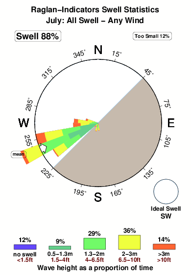
The best conditions reported for surf at Raglan-Indicators occur when a Southwest swell combines with an offshore wind direction from the Southeast.

Voorspelde Golfenergie (Kracht): 12 uur


Raglan-Indicators Surf:
Sunday, 26 July 2026, 16:46 Local time| Sunday 26 | Mon | |||
| 3PM | 6PM | 9PM | 0AM | |
| Wave (m) | ||||
| Periode (s) | 14 | 14 | 14 | 14 |
| Wind (km/h) | ||||
| Wind | glass | cross- off |
off | off |
- /breaks/Raglan-Indicators/forecasts/latest
Raglan-Indicators Surf Guide
Raglan-Indicators in West Coast Auckland is an exposed point break that has reasonably consistent surf and can work at any time of the year. Offshore winds are from the southeast. Waves can be ok even in light onshore winds Waves just as likely from local windswells as from distant groundswells and the ideal swell direction is from the southwest.There is a left breaking point here. It's sometimes crowded here. Watch out for rocks and locals.
Raglan-Indicators Spot Info
Type: Rating: Reliability: Todays Sea Temp*:  Point
Point 5
5fairly consistent 14.2°C*ocean temperature recorded from satelliteSurfing Raglan-Indicators:
The best conditions reported for surf at Raglan-Indicators occur when a Southwest swell combines with an offshore wind direction from the Southeast.
Voorspelde Golfenergie (Kracht): 12 uur
Gebruik de tabbladen hierboven om de zeewatertemperatuur bij Raglan-Indicators te bekijken, foto's van Raglan-Indicators, Raglan-Indicators gedetailleerde golfvoorspellingen, wind- en weersvoorspellingen, Raglan-Indicators webcams, actuele wind in Raglan and West Waikato live weerstations en Raglan-Indicators getijdenvoorspellingen. De link van New Zealand golfkaarten opent een grote afbeelding van New Zealand en de omliggende zeeën. Deze golfkaarten kunnen worden dynamisch gemaakt worden met de verschillende golfcomponenten, golfenergie, golfperiode, golfhoogte, samen met de wind en weersvoorspellingen, het actuele weer en de zeetoestand volgens golfboeien uit New Zealand, langskomende schepen en weerstations op de kust. Elk voorspelling pagina's voor dit surfstrand zijn voorzien van een wereldwijde en regionale golfzoeker om de beste surfsomstandigheden in het gebied rond Raglan-Indicators te vinden.
Raglan-Indicators Surf:
Sunday, 26 July 2026, 16:46 Local timeSunday 26 Mon 3PM 6PM 9PM 0AM Wave (m) Periode (s) 14 14 14 14 Wind (km/h) Wind glass cross-
offoff off - /breaks/Raglan-Indicators/forecasts/latest
- /breaks/Raglan-Indicators/forecasts/latest/six_day
Raglan-Indicators Surf Guide
Raglan-Indicators in West Coast Auckland is an exposed point break that has reasonably consistent surf and can work at any time of the year. Offshore winds are from the southeast. Waves can be ok even in light onshore winds Waves just as likely from local windswells as from distant groundswells and the ideal swell direction is from the southwest.There is a left breaking point here. It's sometimes crowded here. Watch out for rocks and locals.
Raglan-Indicators Spot Info
Type: Rating: Reliability: Todays Sea Temp*: Point5fairly consistent 14.2°C*ocean temperature recorded from satelliteSurfing Raglan-Indicators:
The best conditions reported for surf at Raglan-Indicators occur when a Southwest swell combines with an offshore wind direction from the Southeast.
Voorspelde Golfenergie (Kracht): 12 uur
Gebruik de tabbladen hierboven om de zeewatertemperatuur bij Raglan-Indicators te bekijken, foto's van Raglan-Indicators, Raglan-Indicators gedetailleerde golfvoorspellingen, wind- en weersvoorspellingen, Raglan-Indicators webcams, actuele wind in Raglan and West Waikato live weerstations en Raglan-Indicators getijdenvoorspellingen. De link van New Zealand golfkaarten opent een grote afbeelding van New Zealand en de omliggende zeeën. Deze golfkaarten kunnen worden dynamisch gemaakt worden met de verschillende golfcomponenten, golfenergie, golfperiode, golfhoogte, samen met de wind en weersvoorspellingen, het actuele weer en de zeetoestand volgens golfboeien uit New Zealand, langskomende schepen en weerstations op de kust. Elk voorspelling pagina's voor dit surfstrand zijn voorzien van een wereldwijde en regionale golfzoeker om de beste surfsomstandigheden in het gebied rond Raglan-Indicators te vinden.
Raglan-Indicators Surf:
Sunday, 26 July 2026, 16:46 Local timeSunday 26 Mon 3PM 6PM 9PM 0AM Wave (m) Periode (s) 14 14 14 14 Wind (km/h) Wind glass cross-
offoff off - /breaks/Raglan-Indicators/forecasts/latest
Raglan-Indicators Surf Guide
Raglan-Indicators in West Coast Auckland is an exposed point break that has reasonably consistent surf and can work at any time of the year. Offshore winds are from the southeast. Waves can be ok even in light onshore winds Waves just as likely from local windswells as from distant groundswells and the ideal swell direction is from the southwest.There is a left breaking point here. It's sometimes crowded here. Watch out for rocks and locals.
Raglan-Indicators Spot Info
Type: Rating: Reliability: Todays Sea Temp*: Point5fairly consistent 14.2°C*ocean temperature recorded from satelliteSurfing Raglan-Indicators:
The best conditions reported for surf at Raglan-Indicators occur when a Southwest swell combines with an offshore wind direction from the Southeast.
Voorspelde Golfenergie (Kracht): 12 uur
Gebruik de tabbladen hierboven om de zeewatertemperatuur bij Raglan-Indicators te bekijken, foto's van Raglan-Indicators, Raglan-Indicators gedetailleerde golfvoorspellingen, wind- en weersvoorspellingen, Raglan-Indicators webcams, actuele wind in Raglan and West Waikato live weerstations en Raglan-Indicators getijdenvoorspellingen. De link van New Zealand golfkaarten opent een grote afbeelding van New Zealand en de omliggende zeeën. Deze golfkaarten kunnen worden dynamisch gemaakt worden met de verschillende golfcomponenten, golfenergie, golfperiode, golfhoogte, samen met de wind en weersvoorspellingen, het actuele weer en de zeetoestand volgens golfboeien uit New Zealand, langskomende schepen en weerstations op de kust. Elk voorspelling pagina's voor dit surfstrand zijn voorzien van een wereldwijde en regionale golfzoeker om de beste surfsomstandigheden in het gebied rond Raglan-Indicators te vinden.
Raglan-Indicators Surf:
Sunday, 26 July 2026, 16:46 Local timeSunday 26 Mon 3PM 6PM 9PM 0AM Wave (m) Periode (s) 14 14 14 14 Wind (km/h) Wind glass cross-
offoff off Tide Times:
Voor Ruapuke, %{dist} %{km} van %{location}.
VOLGENDE IS OM (lokale tijd) resterende tijd hoog water laag water Raglan-Indicators Tide Times and Tide Chart
Live Weather:
At Te Akau, 29 km from Raglan-Indicators.
light winds from the SE
(km/h)
DryAir temperature
9°COverall Raglan-Indicators Surf Consistency and Wind Distribution in July
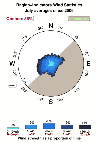


Wind stats for Raglan-Indicators: see the variation in direction and stength by month.
surffoto's uit
de galerijContourlijnen: Wegen & Rivieren: Kies een surflokatie uit het menu 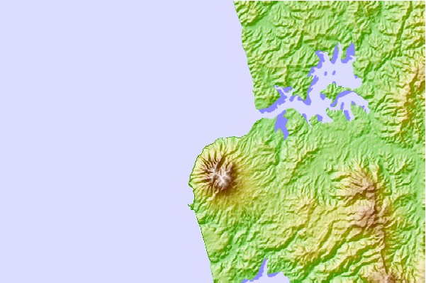
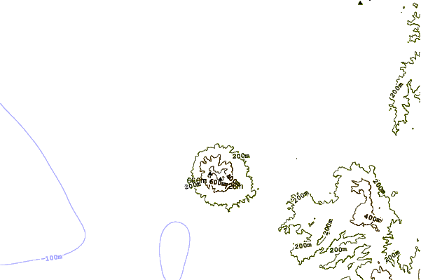
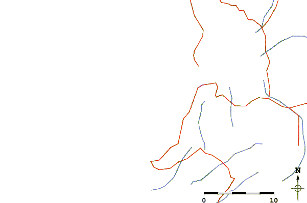
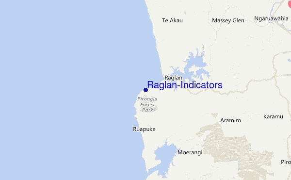
Gebruik deze reliëfkaart om naar de surfspots en de getijdenstations van Raglan and West Waikato toe te gaan, in de buurt van Raglan-Indicators.
Andere Dichtbijzijnde Surflocaties van Raglan-Indicators:
(klik op locatienaam voor meer informatie)- Closest Locatie1 mi
- Second closest Locatie2 mi
- Third closest Locatie2 mi
- Fourth closest Locatie4 mi
- Fifth closest Locatie30 mi
Dichtstbijzijnde golfboeien bij Raglan-Indicators:
- Closest golfboei100 mi
- Second closest golfboei135 mi
- Third closest golfboei221 mi
- Fourth closest golfboei236 mi
- Fifth closest golfboei251 mi
Getijdenstations in de buurt van Raglan-Indicators:
- Closest getijdenstationRaglan6 mi
- Second closest getijdenstationAotea Harbour12 mi
- Third closest getijdenstationKawhia17 mi
- Fourth closest getijdenstationWaikato River Entrance30 mi
- Fifth closest getijdenstationLPG Terminal55 mi
Airports
- The closest passenger airport to Raglan-Indicators is Hamilton Airport (HLZ) in New Zealand, 48 km (30 miles) away (directly).
- The second nearest airport to Raglan-Indicators is Auckland International Airport (AKL), also in New Zealand, 91 km (57 miles) away.
- Third is Tauranga Airport (TRG) in New Zealand, 125 km (78 miles) away.
- Rotorua Airport (ROT) in New Zealand is 138 km (86 miles) away.
- New Plymouth Airport (NPL), also in New Zealand is the fifth nearest airport to Raglan-Indicators and is 142 km (88 miles) away.
- /breaks/Raglan-Indicators/forecasts/latest


 Nearest