

Red Island Surf Guide
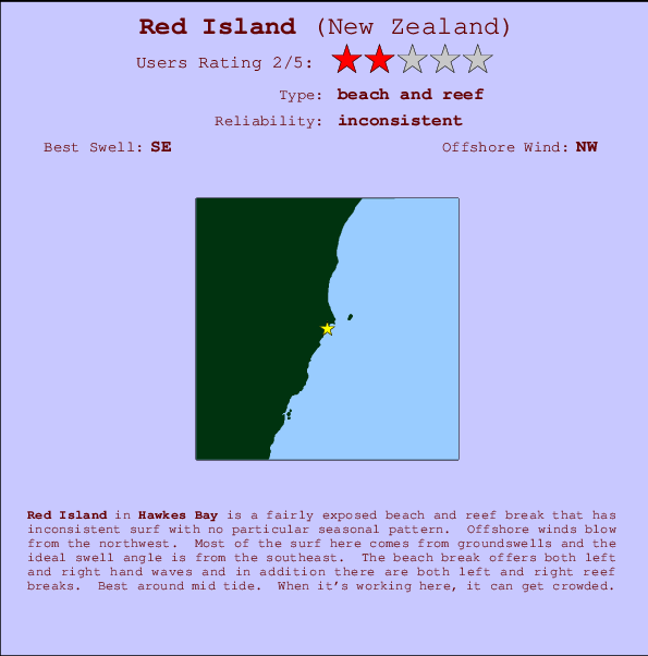
Red Island in Hawkes Bay is a quite exposed beach and reef break that does not work very often with no particular seasonal pattern. Works best in offshore winds from the northwest. Windswells and groundswells in equal measure and the best swell direction is from the southeast. The beach breaks offer lefts and rights and in addition there are both left and right reef breaks.. Best around mid tide. It's sometimes crowded here.
Red Island Spot Info
| Type: | Rating: | Reliability: | Todays Sea Temp*: |
|---|---|---|---|
| inconsistent | 12.6°C*ocean temperature recorded from satellite |
Surfing Red Island:
The best conditions reported for surf at Red Island occur when a Southeast swell combines with an offshore wind direction from the Northwest.

Voorspelde Golfenergie (Kracht): 12 uur


Red Island Surf:
Thursday, 16 July 2026, 04:39 Local time| Thursday 16 | ||||
| 3AM | 6AM | 9AM | 12PM | |
| Wave (m) | ||||
| Periode (s) | 13 | 14 | 15 | 15 |
| Wind (km/h) | ||||
| Wind | cross- off |
cross- off |
off | off |
- /breaks/Red-Island/forecasts/latest
Red Island Surf Guide
Red Island in Hawkes Bay is a quite exposed beach and reef break that does not work very often with no particular seasonal pattern. Works best in offshore winds from the northwest. Windswells and groundswells in equal measure and the best swell direction is from the southeast. The beach breaks offer lefts and rights and in addition there are both left and right reef breaks.. Best around mid tide. It's sometimes crowded here.
Red Island Spot Info
Type: Rating: Reliability: Todays Sea Temp*:  Beach and reef
 2
2inconsistent 12.6°C*ocean temperature recorded from satelliteSurfing Red Island:
The best conditions reported for surf at Red Island occur when a Southeast swell combines with an offshore wind direction from the Northwest.
Voorspelde Golfenergie (Kracht): 12 uur
Gebruik de tabbladen hierboven om de zeewatertemperatuur bij Red Island te bekijken, foto's van Red Island, Red Island gedetailleerde golfvoorspellingen, wind- en weersvoorspellingen, Red Island webcams, actuele wind in Hawkes Bay live weerstations en Red Island getijdenvoorspellingen. De link van New Zealand golfkaarten opent een grote afbeelding van New Zealand en de omliggende zeeën. Deze golfkaarten kunnen worden dynamisch gemaakt worden met de verschillende golfcomponenten, golfenergie, golfperiode, golfhoogte, samen met de wind en weersvoorspellingen, het actuele weer en de zeetoestand volgens golfboeien uit New Zealand, langskomende schepen en weerstations op de kust. Elk voorspelling pagina's voor dit surfstrand zijn voorzien van een wereldwijde en regionale golfzoeker om de beste surfsomstandigheden in het gebied rond Red Island te vinden.
Red Island Surf:
Thursday, 16 July 2026, 04:39 Local timeThursday 16 3AM 6AM 9AM 12PM Wave (m) Periode (s) 13 14 15 15 Wind (km/h) Wind cross-
offcross-
offoff off - /breaks/Red-Island/forecasts/latest
- /breaks/Red-Island/forecasts/latest/six_day
Red Island Surf Guide
Red Island in Hawkes Bay is a quite exposed beach and reef break that does not work very often with no particular seasonal pattern. Works best in offshore winds from the northwest. Windswells and groundswells in equal measure and the best swell direction is from the southeast. The beach breaks offer lefts and rights and in addition there are both left and right reef breaks.. Best around mid tide. It's sometimes crowded here.
Red Island Spot Info
Type: Rating: Reliability: Todays Sea Temp*: Beach and reef2inconsistent 12.6°C*ocean temperature recorded from satelliteSurfing Red Island:
The best conditions reported for surf at Red Island occur when a Southeast swell combines with an offshore wind direction from the Northwest.
Voorspelde Golfenergie (Kracht): 12 uur
Gebruik de tabbladen hierboven om de zeewatertemperatuur bij Red Island te bekijken, foto's van Red Island, Red Island gedetailleerde golfvoorspellingen, wind- en weersvoorspellingen, Red Island webcams, actuele wind in Hawkes Bay live weerstations en Red Island getijdenvoorspellingen. De link van New Zealand golfkaarten opent een grote afbeelding van New Zealand en de omliggende zeeën. Deze golfkaarten kunnen worden dynamisch gemaakt worden met de verschillende golfcomponenten, golfenergie, golfperiode, golfhoogte, samen met de wind en weersvoorspellingen, het actuele weer en de zeetoestand volgens golfboeien uit New Zealand, langskomende schepen en weerstations op de kust. Elk voorspelling pagina's voor dit surfstrand zijn voorzien van een wereldwijde en regionale golfzoeker om de beste surfsomstandigheden in het gebied rond Red Island te vinden.
Red Island Surf:
Thursday, 16 July 2026, 04:39 Local timeThursday 16 3AM 6AM 9AM 12PM Wave (m) Periode (s) 13 14 15 15 Wind (km/h) Wind cross-
offcross-
offoff off - /breaks/Red-Island/forecasts/latest
Red Island Surf Guide
Red Island in Hawkes Bay is a quite exposed beach and reef break that does not work very often with no particular seasonal pattern. Works best in offshore winds from the northwest. Windswells and groundswells in equal measure and the best swell direction is from the southeast. The beach breaks offer lefts and rights and in addition there are both left and right reef breaks.. Best around mid tide. It's sometimes crowded here.
Red Island Spot Info
Type: Rating: Reliability: Todays Sea Temp*: Beach and reef2inconsistent 12.6°C*ocean temperature recorded from satelliteSurfing Red Island:
The best conditions reported for surf at Red Island occur when a Southeast swell combines with an offshore wind direction from the Northwest.
Voorspelde Golfenergie (Kracht): 12 uur
Gebruik de tabbladen hierboven om de zeewatertemperatuur bij Red Island te bekijken, foto's van Red Island, Red Island gedetailleerde golfvoorspellingen, wind- en weersvoorspellingen, Red Island webcams, actuele wind in Hawkes Bay live weerstations en Red Island getijdenvoorspellingen. De link van New Zealand golfkaarten opent een grote afbeelding van New Zealand en de omliggende zeeën. Deze golfkaarten kunnen worden dynamisch gemaakt worden met de verschillende golfcomponenten, golfenergie, golfperiode, golfhoogte, samen met de wind en weersvoorspellingen, het actuele weer en de zeetoestand volgens golfboeien uit New Zealand, langskomende schepen en weerstations op de kust. Elk voorspelling pagina's voor dit surfstrand zijn voorzien van een wereldwijde en regionale golfzoeker om de beste surfsomstandigheden in het gebied rond Red Island te vinden.
Red Island Surf:
Thursday, 16 July 2026, 04:39 Local timeThursday 16 3AM 6AM 9AM 12PM Wave (m) Periode (s) 13 14 15 15 Wind (km/h) Wind cross-
offcross-
offoff off Tide Times:
Voor Cray Bay, %{dist} %{km} van %{location}.
VOLGENDE IS OM (lokale tijd) resterende tijd hoog water laag water Red Island Tide Times and Tide Chart
Live Weather:
At Te Mata Peak, 17 km from Red Island.
light winds from the NE
(km/h)Air temperature
-°COverall Red Island Surf Consistency and Wind Distribution in July
surffoto's uit
de galerijContourlijnen: Wegen & Rivieren: Kies een surflokatie uit het menu 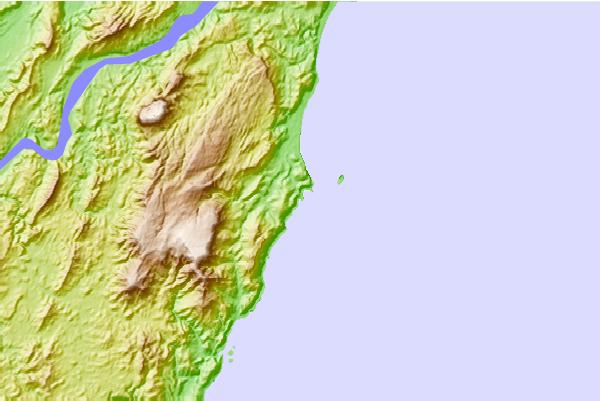
Gebruik deze reliëfkaart om naar de surfspots en de getijdenstations van Hawkes Bay toe te gaan, in de buurt van Red Island.
Andere Dichtbijzijnde Surflocaties van Red Island:
(klik op locatienaam voor meer informatie)- Closest Locatie1 mi
- Second closest Locatie2 mi
- Third closest Locatie6 mi
- Fourth closest Locatie14 mi
- Fifth closest Locatie14 mi
Dichtstbijzijnde golfboeien bij Red Island:
- Closest golfboei150 mi
- Second closest golfboei169 mi
- Third closest golfboei219 mi
- Fourth closest golfboei222 mi
- Fifth closest golfboei305 mi
Getijdenstations in de buurt van Red Island:
- Closest getijdenstationNapier25 mi
- Second closest getijdenstationWairoa River60 mi
- Third closest getijdenstationWaikokopu70 mi
- Fourth closest getijdenstationCastlepoint85 mi
- Fifth closest getijdenstationGisborne98 mi
Airports
- The closest passenger airport to Red Island is Palmerston North Airport (PMR) in New Zealand, 128 km (80 miles) away (directly).
- The second nearest airport to Red Island is Taupo Airport (TUO), also in New Zealand, 146 km (91 miles) away.
- Third is Gisborne Airport (GIS) in New Zealand, 157 km (98 miles) away.
- Wanganui Airport (WAG) in New Zealand is 168 km (104 miles) away.
- Masterton Airport (MRO), also in New Zealand is the fifth nearest airport to Red Island and is 170 km (106 miles) away.
- /breaks/Red-Island/forecasts/latest


 Nearest