
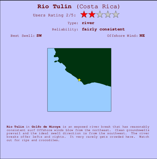
Rio Tulin Surf Guide
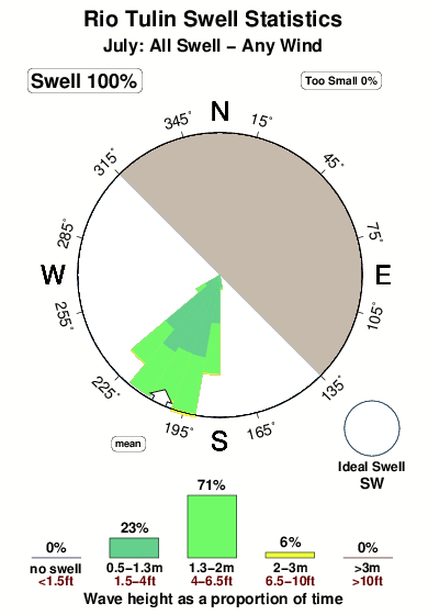
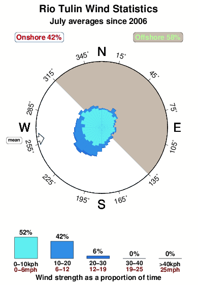
Rio Tulin in Golfo de Nicoya is an exposed river break that has fairly consistent surf The best wind direction is from the northeast. Groundswells are more common than windswells and the ideal swell direction is from the southwest. Waves at the river break both left and right. It very rarely gets crowded here. Beware of rips and crocodiles.
Rio Tulin Spot Info
| Type: | Rating: | Reliability: | Todays Sea Temp*: |
|---|---|---|---|
| fairly consistent | 30.2°C*ocean temperature recorded from satellite |
Surfing Rio Tulin:
The best conditions reported for surf at Rio Tulin occur when a Southwest swell combines with an offshore wind direction from the Northeast.

Voorspelde Golfenergie (Kracht): 12 uur


Rio Tulin Surf:
Friday, 17 July 2026, 15:58 Local time| Friday 17 | Sat | |||
| 3PM | 6PM | 9PM | 0AM | |
| Wave (m) | ||||
| Periode (s) | 14 | 13 | 13 | 13 |
| Wind (km/h) | ||||
| Wind | cross- on |
on | glass | glass |
- /breaks/Rio-Tulin/forecasts/latest
Rio Tulin Surf Guide
Rio Tulin in Golfo de Nicoya is an exposed river break that has fairly consistent surf The best wind direction is from the northeast. Groundswells are more common than windswells and the ideal swell direction is from the southwest. Waves at the river break both left and right. It very rarely gets crowded here. Beware of rips and crocodiles.
Rio Tulin Spot Info
Type: Rating: Reliability: Todays Sea Temp*:  River
River 2
2fairly consistent 30.2°C*ocean temperature recorded from satelliteSurfing Rio Tulin:
The best conditions reported for surf at Rio Tulin occur when a Southwest swell combines with an offshore wind direction from the Northeast.
Voorspelde Golfenergie (Kracht): 12 uur
Gebruik de tabbladen hierboven om de zeewatertemperatuur bij Rio Tulin te bekijken, foto's van Rio Tulin, Rio Tulin gedetailleerde golfvoorspellingen, wind- en weersvoorspellingen, Rio Tulin webcams, actuele wind in Golfo de Nicoya live weerstations en Rio Tulin getijdenvoorspellingen. De link van Costa Rica golfkaarten opent een grote afbeelding van Costa Rica en de omliggende zeeën. Deze golfkaarten kunnen worden dynamisch gemaakt worden met de verschillende golfcomponenten, golfenergie, golfperiode, golfhoogte, samen met de wind en weersvoorspellingen, het actuele weer en de zeetoestand volgens golfboeien uit Costa Rica, langskomende schepen en weerstations op de kust. Elk voorspelling pagina's voor dit surfstrand zijn voorzien van een wereldwijde en regionale golfzoeker om de beste surfsomstandigheden in het gebied rond Rio Tulin te vinden.
Rio Tulin Surf:
Friday, 17 July 2026, 15:58 Local timeFriday 17 Sat 3PM 6PM 9PM 0AM Wave (m) Periode (s) 14 13 13 13 Wind (km/h) Wind cross-
onon glass glass - /breaks/Rio-Tulin/forecasts/latest
- /breaks/Rio-Tulin/forecasts/latest/six_day
Rio Tulin Surf Guide
Rio Tulin in Golfo de Nicoya is an exposed river break that has fairly consistent surf The best wind direction is from the northeast. Groundswells are more common than windswells and the ideal swell direction is from the southwest. Waves at the river break both left and right. It very rarely gets crowded here. Beware of rips and crocodiles.
Rio Tulin Spot Info
Type: Rating: Reliability: Todays Sea Temp*: River2fairly consistent 30.2°C*ocean temperature recorded from satelliteSurfing Rio Tulin:
The best conditions reported for surf at Rio Tulin occur when a Southwest swell combines with an offshore wind direction from the Northeast.
Voorspelde Golfenergie (Kracht): 12 uur
Gebruik de tabbladen hierboven om de zeewatertemperatuur bij Rio Tulin te bekijken, foto's van Rio Tulin, Rio Tulin gedetailleerde golfvoorspellingen, wind- en weersvoorspellingen, Rio Tulin webcams, actuele wind in Golfo de Nicoya live weerstations en Rio Tulin getijdenvoorspellingen. De link van Costa Rica golfkaarten opent een grote afbeelding van Costa Rica en de omliggende zeeën. Deze golfkaarten kunnen worden dynamisch gemaakt worden met de verschillende golfcomponenten, golfenergie, golfperiode, golfhoogte, samen met de wind en weersvoorspellingen, het actuele weer en de zeetoestand volgens golfboeien uit Costa Rica, langskomende schepen en weerstations op de kust. Elk voorspelling pagina's voor dit surfstrand zijn voorzien van een wereldwijde en regionale golfzoeker om de beste surfsomstandigheden in het gebied rond Rio Tulin te vinden.
Rio Tulin Surf:
Friday, 17 July 2026, 15:58 Local timeFriday 17 Sat 3PM 6PM 9PM 0AM Wave (m) Periode (s) 14 13 13 13 Wind (km/h) Wind cross-
onon glass glass - /breaks/Rio-Tulin/forecasts/latest
Rio Tulin Surf Guide
Rio Tulin in Golfo de Nicoya is an exposed river break that has fairly consistent surf The best wind direction is from the northeast. Groundswells are more common than windswells and the ideal swell direction is from the southwest. Waves at the river break both left and right. It very rarely gets crowded here. Beware of rips and crocodiles.
Rio Tulin Spot Info
Type: Rating: Reliability: Todays Sea Temp*: River2fairly consistent 30.2°C*ocean temperature recorded from satelliteSurfing Rio Tulin:
The best conditions reported for surf at Rio Tulin occur when a Southwest swell combines with an offshore wind direction from the Northeast.
Voorspelde Golfenergie (Kracht): 12 uur
Gebruik de tabbladen hierboven om de zeewatertemperatuur bij Rio Tulin te bekijken, foto's van Rio Tulin, Rio Tulin gedetailleerde golfvoorspellingen, wind- en weersvoorspellingen, Rio Tulin webcams, actuele wind in Golfo de Nicoya live weerstations en Rio Tulin getijdenvoorspellingen. De link van Costa Rica golfkaarten opent een grote afbeelding van Costa Rica en de omliggende zeeën. Deze golfkaarten kunnen worden dynamisch gemaakt worden met de verschillende golfcomponenten, golfenergie, golfperiode, golfhoogte, samen met de wind en weersvoorspellingen, het actuele weer en de zeetoestand volgens golfboeien uit Costa Rica, langskomende schepen en weerstations op de kust. Elk voorspelling pagina's voor dit surfstrand zijn voorzien van een wereldwijde en regionale golfzoeker om de beste surfsomstandigheden in het gebied rond Rio Tulin te vinden.
Rio Tulin Surf:
Friday, 17 July 2026, 15:58 Local timeFriday 17 Sat 3PM 6PM 9PM 0AM Wave (m) Periode (s) 14 13 13 13 Wind (km/h) Wind cross-
onon glass glass Tide Times:
Voor Gully's, %{dist} %{km} van %{location}.
VOLGENDE IS OM (lokale tijd) resterende tijd hoog water laag water Rio Tulin Tide Times and Tide Chart
Live Weather:
At Juan Santamaria Airport, 63 km from Rio Tulin.
wind obs. (24 kph from 80 degs) was rejected
(km/h)
Shower - in the vicinityAir temperature
27°COverall Rio Tulin Surf Consistency and Wind Distribution in July
surffoto's uit
de galerijContourlijnen: Wegen & Rivieren: Kies een surflokatie uit het menu 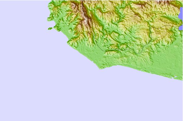
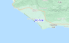
Gebruik deze reliëfkaart om naar de surfspots en de getijdenstations van Golfo de Nicoya toe te gaan, in de buurt van Rio Tulin.
Andere Dichtbijzijnde Surflocaties van Rio Tulin:
(klik op locatienaam voor meer informatie)- Closest Locatie2 mi
- Second closest Locatie3 mi
- Third closest Locatie4 mi
- Fourth closest Locatie5 mi
- Fifth closest Locatie6 mi
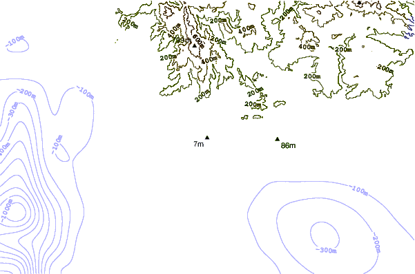
Dichtstbijzijnde golfboeien bij Rio Tulin:
- Closest golfboei544 mi
- Second closest golfboei715 mi
- Third closest golfboei1068 mi
- Fourth closest golfboei1119 mi
- Fifth closest golfboei1138 mi
Getijdenstations in de buurt van Rio Tulin:
- Closest getijdenstationChacarita34 mi
- Second closest getijdenstationPunta Arenas35 mi
- Third closest getijdenstationLimon109 mi
- Fourth closest getijdenstationSan Juan del Norte (Greytown)112 mi
- Fifth closest getijdenstationGolfito114 mi
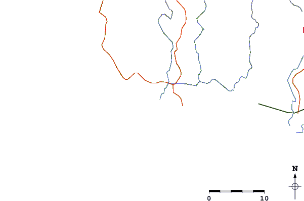
Airports
- The closest passenger airport to Rio Tulin is Quepos Managua Airport (XQP) in Costa Rica, 48 km (30 miles) away (directly).
- The second nearest airport to Rio Tulin is Juan Santamaria International Airport (SJO), also in Costa Rica, 63 km (39 miles) away.
- Third is Nosara Airport (NOB) in Costa Rica, 129 km (80 miles) away.
- Palmar Sur Airport (PMZ) in Costa Rica is 136 km (84 miles) away.
- Daniel Oduber Quiros International (Liberia) Airport (LIR), also in Costa Rica is the fifth nearest airport to Rio Tulin and is 159 km (99 miles) away.
- /breaks/Rio-Tulin/forecasts/latest


 Nearest