

Santa Cruz Surf Guide
Santa Cruz in Nayarit is an exposed point/Rivermouth break that has quite reliable surf. Summer offers the favoured conditions for surfing. Offshore winds are from the east. Groundswells more frequent than windswells and the ideal swell direction is from the southwest.The waves is a point break that peels left. Rarely crowded here. Beware of rips, sharks and rocks.
Santa Cruz Spot Info
| Type: | Rating: | Reliability: | Todays Sea Temp*: |
|---|---|---|---|
| fairly consistent | 31.5°C*ocean temperature recorded from satellite |
Surfing Santa Cruz:
The best conditions reported for surf at Santa Cruz occur when a Southwest swell combines with an offshore wind direction from the East.
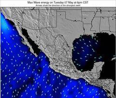
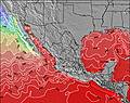
Voorspelde Golfenergie (Kracht): 12 uur


Santa Cruz Surf:
Thursday, 16 July 2026, 14:15 Local time| Thursday 16 | Fri | |||
| 3PM | 6PM | 9PM | 0AM | |
| Wave (m) | ||||
| Periode (s) | 15 | 15 | 15 | 19 |
| Wind (km/h) | ||||
| Wind | on | on | glass | glass |
- /breaks/Santa-Cruz_1/forecasts/latest
Santa Cruz Surf Guide
Santa Cruz in Nayarit is an exposed point/Rivermouth break that has quite reliable surf. Summer offers the favoured conditions for surfing. Offshore winds are from the east. Groundswells more frequent than windswells and the ideal swell direction is from the southwest.The waves is a point break that peels left. Rarely crowded here. Beware of rips, sharks and rocks.
Santa Cruz Spot Info
Type: Rating: Reliability: Todays Sea Temp*:  Point/river
 1
1fairly consistent 31.5°C*ocean temperature recorded from satelliteSurfing Santa Cruz:
The best conditions reported for surf at Santa Cruz occur when a Southwest swell combines with an offshore wind direction from the East.
Voorspelde Golfenergie (Kracht): 12 uur
Gebruik de tabbladen hierboven om de zeewatertemperatuur bij Santa Cruz te bekijken, foto's van Santa Cruz, Santa Cruz gedetailleerde golfvoorspellingen, wind- en weersvoorspellingen, Santa Cruz webcams, actuele wind in Nayarit live weerstations en Santa Cruz getijdenvoorspellingen. De link van Mexico golfkaarten opent een grote afbeelding van Mexico en de omliggende zeeën. Deze golfkaarten kunnen worden dynamisch gemaakt worden met de verschillende golfcomponenten, golfenergie, golfperiode, golfhoogte, samen met de wind en weersvoorspellingen, het actuele weer en de zeetoestand volgens golfboeien uit Mexico, langskomende schepen en weerstations op de kust. Elk voorspelling pagina's voor dit surfstrand zijn voorzien van een wereldwijde en regionale golfzoeker om de beste surfsomstandigheden in het gebied rond Santa Cruz te vinden.
Santa Cruz Surf:
Thursday, 16 July 2026, 14:15 Local timeThursday 16 Fri 3PM 6PM 9PM 0AM Wave (m) Periode (s) 15 15 15 19 Wind (km/h) Wind on on glass glass - /breaks/Santa-Cruz_1/forecasts/latest
- /breaks/Santa-Cruz_1/forecasts/latest/six_day
Santa Cruz Surf Guide
Santa Cruz in Nayarit is an exposed point/Rivermouth break that has quite reliable surf. Summer offers the favoured conditions for surfing. Offshore winds are from the east. Groundswells more frequent than windswells and the ideal swell direction is from the southwest.The waves is a point break that peels left. Rarely crowded here. Beware of rips, sharks and rocks.
Santa Cruz Spot Info
Type: Rating: Reliability: Todays Sea Temp*: Point/river1fairly consistent 31.5°C*ocean temperature recorded from satelliteSurfing Santa Cruz:
The best conditions reported for surf at Santa Cruz occur when a Southwest swell combines with an offshore wind direction from the East.
Voorspelde Golfenergie (Kracht): 12 uur
Gebruik de tabbladen hierboven om de zeewatertemperatuur bij Santa Cruz te bekijken, foto's van Santa Cruz, Santa Cruz gedetailleerde golfvoorspellingen, wind- en weersvoorspellingen, Santa Cruz webcams, actuele wind in Nayarit live weerstations en Santa Cruz getijdenvoorspellingen. De link van Mexico golfkaarten opent een grote afbeelding van Mexico en de omliggende zeeën. Deze golfkaarten kunnen worden dynamisch gemaakt worden met de verschillende golfcomponenten, golfenergie, golfperiode, golfhoogte, samen met de wind en weersvoorspellingen, het actuele weer en de zeetoestand volgens golfboeien uit Mexico, langskomende schepen en weerstations op de kust. Elk voorspelling pagina's voor dit surfstrand zijn voorzien van een wereldwijde en regionale golfzoeker om de beste surfsomstandigheden in het gebied rond Santa Cruz te vinden.
Santa Cruz Surf:
Thursday, 16 July 2026, 14:15 Local timeThursday 16 Fri 3PM 6PM 9PM 0AM Wave (m) Periode (s) 15 15 15 19 Wind (km/h) Wind on on glass glass - /breaks/Santa-Cruz_1/forecasts/latest
Santa Cruz Surf Guide
Santa Cruz in Nayarit is an exposed point/Rivermouth break that has quite reliable surf. Summer offers the favoured conditions for surfing. Offshore winds are from the east. Groundswells more frequent than windswells and the ideal swell direction is from the southwest.The waves is a point break that peels left. Rarely crowded here. Beware of rips, sharks and rocks.
Santa Cruz Spot Info
Type: Rating: Reliability: Todays Sea Temp*: Point/river1fairly consistent 31.5°C*ocean temperature recorded from satelliteSurfing Santa Cruz:
The best conditions reported for surf at Santa Cruz occur when a Southwest swell combines with an offshore wind direction from the East.
Voorspelde Golfenergie (Kracht): 12 uur
Gebruik de tabbladen hierboven om de zeewatertemperatuur bij Santa Cruz te bekijken, foto's van Santa Cruz, Santa Cruz gedetailleerde golfvoorspellingen, wind- en weersvoorspellingen, Santa Cruz webcams, actuele wind in Nayarit live weerstations en Santa Cruz getijdenvoorspellingen. De link van Mexico golfkaarten opent een grote afbeelding van Mexico en de omliggende zeeën. Deze golfkaarten kunnen worden dynamisch gemaakt worden met de verschillende golfcomponenten, golfenergie, golfperiode, golfhoogte, samen met de wind en weersvoorspellingen, het actuele weer en de zeetoestand volgens golfboeien uit Mexico, langskomende schepen en weerstations op de kust. Elk voorspelling pagina's voor dit surfstrand zijn voorzien van een wereldwijde en regionale golfzoeker om de beste surfsomstandigheden in het gebied rond Santa Cruz te vinden.
Santa Cruz Surf:
Thursday, 16 July 2026, 14:15 Local timeThursday 16 Fri 3PM 6PM 9PM 0AM Wave (m) Periode (s) 15 15 15 19 Wind (km/h) Wind on on glass glass Tide Times:
Voor Platanitos, %{dist} %{km} van %{location}.
VOLGENDE IS OM (lokale tijd) resterende tijd hoog water laag water Santa Cruz Tide Times and Tide Chart
Live Weather:
At Tepic Airport, 33 km from Santa Cruz.
wind obs. (17 kph from 180 degs) was rejected
(km/h)
Dry and partly cloudyAir temperature
26°COverall Santa Cruz Surf Consistency and Wind Distribution in July
surffoto's uit
de galerijContourlijnen: Wegen & Rivieren: Kies een surflokatie uit het menu 


Gebruik deze reliëfkaart om naar de surfspots en de getijdenstations van Nayarit toe te gaan, in de buurt van Santa Cruz.
Andere Dichtbijzijnde Surflocaties van Santa Cruz:
(klik op locatienaam voor meer informatie)- Closest Locatie3 mi
- Second closest Locatie6 mi
- Third closest Locatie6 mi
- Fourth closest Locatie6 mi
- Fifth closest Locatie7 mi
Dichtstbijzijnde golfboeien bij Santa Cruz:
- Closest golfboei658 mi
- Second closest golfboei717 mi
- Third closest golfboei763 mi
- Fourth closest golfboei790 mi
- Fifth closest golfboei863 mi
Getijdenstations in de buurt van Santa Cruz:
- Closest getijdenstationSan Blas7 mi
- Second closest getijdenstationBucerias48 mi
- Third closest getijdenstationPuerto Vallarta57 mi
- Fourth closest getijdenstationIsla del Bosque99 mi
- Fifth closest getijdenstationMazatlan145 mi
Airports
- The nearest passenger airport to Santa Cruz is Tepic Airport (TPQ) in Mexico, which is 38 km (24 miles) away (directly).
- The second closest airport to Santa Cruz is Licenciado Gustavo Diaz Ordaz International (Puerto Vallarta) Airport (PVR), also in Mexico, 84 km (52 miles) away.

- /breaks/Santa-Cruz_1/forecasts/latest


 Nearest