

Santa Maria Surf Guide
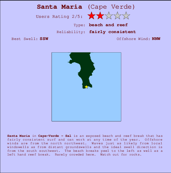
Santa Maria in Sal is an exposed beach and reef break that has reasonably consistent surf and can work at any time of the year. The best wind direction is from the north northwest. Tends to receive a mix of groundswells and windswells and the ideal swell direction is from the south southwest. The beach break provides left and right handers and there is also a left hand reef break.. Relatively few surfers here, even on good days. Submerged rocks are a hazard.
Santa Maria Spot Info
| Type: | Rating: | Reliability: | Todays Sea Temp*: |
|---|---|---|---|
| fairly consistent | 24.2°C*ocean temperature recorded from satellite |
Surfing Santa Maria:
The best conditions reported for surf at Santa Maria occur when a South-southwest swell combines with an offshore wind direction from the North-northwest.
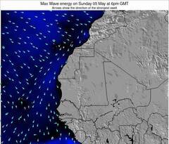
Voorspelde Golfenergie (Kracht): 12 uur
Santa Maria Surf:
Tuesday, 14 July 2026, 17:04 Local time| Tuesday 14 | ||||
| 2PM | 5PM | 8PM | 11PM | |
| Wave (m) | ||||
| Periode (s) | 12 | 12 | 12 | 12 |
| Wind (km/h) | ||||
| Wind | cross- off |
cross- off |
cross- off |
cross- off |
- /breaks/Santa-Maria_1/forecasts/latest
Santa Maria Surf Guide
Santa Maria in Sal is an exposed beach and reef break that has reasonably consistent surf and can work at any time of the year. The best wind direction is from the north northwest. Tends to receive a mix of groundswells and windswells and the ideal swell direction is from the south southwest. The beach break provides left and right handers and there is also a left hand reef break.. Relatively few surfers here, even on good days. Submerged rocks are a hazard.
Santa Maria Spot Info
Type: Rating: Reliability: Todays Sea Temp*:  Beach and reef
 2
2fairly consistent 24.2°C*ocean temperature recorded from satelliteSurfing Santa Maria:
The best conditions reported for surf at Santa Maria occur when a South-southwest swell combines with an offshore wind direction from the North-northwest.
Voorspelde Golfenergie (Kracht): 12 uur
Gebruik de tabbladen hierboven om de zeewatertemperatuur bij Santa Maria te bekijken, foto's van Santa Maria, Santa Maria gedetailleerde golfvoorspellingen, wind- en weersvoorspellingen, Santa Maria webcams, actuele wind in Sal live weerstations en Santa Maria getijdenvoorspellingen. De link van Cape Verde golfkaarten opent een grote afbeelding van Cape Verde en de omliggende zeeën. Deze golfkaarten kunnen worden dynamisch gemaakt worden met de verschillende golfcomponenten, golfenergie, golfperiode, golfhoogte, samen met de wind en weersvoorspellingen, het actuele weer en de zeetoestand volgens golfboeien uit Cape Verde, langskomende schepen en weerstations op de kust. Elk voorspelling pagina's voor dit surfstrand zijn voorzien van een wereldwijde en regionale golfzoeker om de beste surfsomstandigheden in het gebied rond Santa Maria te vinden.
Santa Maria Surf:
Tuesday, 14 July 2026, 17:04 Local timeTuesday 14 2PM 5PM 8PM 11PM Wave (m) Periode (s) 12 12 12 12 Wind (km/h) Wind cross-
offcross-
offcross-
offcross-
off- /breaks/Santa-Maria_1/forecasts/latest
- /breaks/Santa-Maria_1/forecasts/latest/six_day
Santa Maria Surf Guide
Santa Maria in Sal is an exposed beach and reef break that has reasonably consistent surf and can work at any time of the year. The best wind direction is from the north northwest. Tends to receive a mix of groundswells and windswells and the ideal swell direction is from the south southwest. The beach break provides left and right handers and there is also a left hand reef break.. Relatively few surfers here, even on good days. Submerged rocks are a hazard.
Santa Maria Spot Info
Type: Rating: Reliability: Todays Sea Temp*: Beach and reef2fairly consistent 24.2°C*ocean temperature recorded from satelliteSurfing Santa Maria:
The best conditions reported for surf at Santa Maria occur when a South-southwest swell combines with an offshore wind direction from the North-northwest.
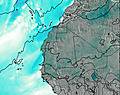
Voorspelde Golfenergie (Kracht): 12 uur
Gebruik de tabbladen hierboven om de zeewatertemperatuur bij Santa Maria te bekijken, foto's van Santa Maria, Santa Maria gedetailleerde golfvoorspellingen, wind- en weersvoorspellingen, Santa Maria webcams, actuele wind in Sal live weerstations en Santa Maria getijdenvoorspellingen. De link van Cape Verde golfkaarten opent een grote afbeelding van Cape Verde en de omliggende zeeën. Deze golfkaarten kunnen worden dynamisch gemaakt worden met de verschillende golfcomponenten, golfenergie, golfperiode, golfhoogte, samen met de wind en weersvoorspellingen, het actuele weer en de zeetoestand volgens golfboeien uit Cape Verde, langskomende schepen en weerstations op de kust. Elk voorspelling pagina's voor dit surfstrand zijn voorzien van een wereldwijde en regionale golfzoeker om de beste surfsomstandigheden in het gebied rond Santa Maria te vinden.
Santa Maria Surf:
Tuesday, 14 July 2026, 17:04 Local timeTuesday 14 2PM 5PM 8PM 11PM Wave (m) Periode (s) 12 12 12 12 Wind (km/h) Wind cross-
offcross-
offcross-
offcross-
off- /breaks/Santa-Maria_1/forecasts/latest
Santa Maria Surf Guide
Santa Maria in Sal is an exposed beach and reef break that has reasonably consistent surf and can work at any time of the year. The best wind direction is from the north northwest. Tends to receive a mix of groundswells and windswells and the ideal swell direction is from the south southwest. The beach break provides left and right handers and there is also a left hand reef break.. Relatively few surfers here, even on good days. Submerged rocks are a hazard.
Santa Maria Spot Info
Type: Rating: Reliability: Todays Sea Temp*: Beach and reef2fairly consistent 24.2°C*ocean temperature recorded from satelliteSurfing Santa Maria:
The best conditions reported for surf at Santa Maria occur when a South-southwest swell combines with an offshore wind direction from the North-northwest.
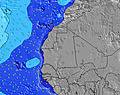
Voorspelde Golfenergie (Kracht): 12 uur
Gebruik de tabbladen hierboven om de zeewatertemperatuur bij Santa Maria te bekijken, foto's van Santa Maria, Santa Maria gedetailleerde golfvoorspellingen, wind- en weersvoorspellingen, Santa Maria webcams, actuele wind in Sal live weerstations en Santa Maria getijdenvoorspellingen. De link van Cape Verde golfkaarten opent een grote afbeelding van Cape Verde en de omliggende zeeën. Deze golfkaarten kunnen worden dynamisch gemaakt worden met de verschillende golfcomponenten, golfenergie, golfperiode, golfhoogte, samen met de wind en weersvoorspellingen, het actuele weer en de zeetoestand volgens golfboeien uit Cape Verde, langskomende schepen en weerstations op de kust. Elk voorspelling pagina's voor dit surfstrand zijn voorzien van een wereldwijde en regionale golfzoeker om de beste surfsomstandigheden in het gebied rond Santa Maria te vinden.
Santa Maria Surf:
Tuesday, 14 July 2026, 17:04 Local timeTuesday 14 2PM 5PM 8PM 11PM Wave (m) Periode (s) 12 12 12 12 Wind (km/h) Wind cross-
offcross-
offcross-
offcross-
offTide Times:
Voor Santa Maria, %{dist} %{km} van %{location}.
VOLGENDE IS OM (lokale tijd) resterende tijd hoog water laag water Santa Maria Tide Times and Tide Chart
Live Weather:
At Sal Island/Amilcar Cabral International Airport, 14 km from Santa Maria.
fresh winds from the N
(km/h)
Dry and partly cloudyAir temperature
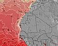
27°COverall Santa Maria Surf Consistency and Wind Distribution in July

Wind stats for Santa Maria: see the variation in direction and stength by month.
surffoto's uit
de galerijContourlijnen: Wegen & Rivieren: Kies een surflokatie uit het menu 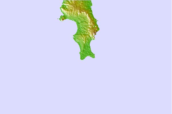
Gebruik deze reliëfkaart om naar de surfspots en de getijdenstations van Sal toe te gaan, in de buurt van Santa Maria.
Andere Dichtbijzijnde Surflocaties van Santa Maria:
(klik op locatienaam voor meer informatie)- Closest Locatie1 mi
- Second closest Locatie1 mi
- Third closest Locatie1 mi
- Fourth closest Locatie2 mi
- Fifth closest Locatie8 mi
Dichtstbijzijnde golfboeien bij Santa Maria:
- Closest golfboei1180 mi
- Second closest golfboei1198 mi
- Third closest golfboei1471 mi
- Fourth closest golfboei1517 mi
- Fifth closest golfboei1546 mi
Getijdenstations in de buurt van Santa Maria:
- Closest getijdenstationSanta Maria1 mi
- Second closest getijdenstationVila da Ribeira Brava92 mi
- Third closest getijdenstationTarrafal107 mi
- Fourth closest getijdenstationPorto Grande, Cape Verde Islands139 mi
- Fifth closest getijdenstationPorto Novo145 mi
Airports
- The closest passenger airport to Santa Maria is Amilcar Cabral International Airport (SID) in Cape Verde Islands, 17 km (11 miles) away (directly).
- The second nearest airport to Santa Maria is Rabil (Boa Vista) Airport (BVC), also in Cape Verde Islands, 51 km (32 miles) away.
- Third is Preguica (Sao Nocolau Island) Airport (SNE) in Cape Verde Islands, 146 km (91 miles) away.
- Maio Airport (MMO) in Cape Verde Islands is 163 km (101 miles) away.
- Francisco Mendes Airport (RAI), also in Cape Verde Islands is the fifth nearest airport to Santa Maria and is 196 km (122 miles) away.
- /breaks/Santa-Maria_1/forecasts/latest

 Nearest