
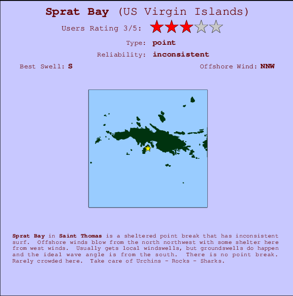
Sprat Bay Surf Guide
Sprat Bay in Saint Thomas is a sheltered point break that has unreliable waves. Offshore winds blow from the north northwest with some shelter here from west winds. Windswells are much more typical than groudswells and the ideal wave direction is from the south. There is no point break. It very rarely gets crowded here. Hazards include Urchins - Rocks - Sharks.
Sprat Bay Spot Info
| Type: | Rating: | Reliability: | Todays Sea Temp*: |
|---|---|---|---|
| inconsistent | 28.3°C*ocean temperature recorded from satellite |
Surfing Sprat Bay:
The best conditions reported for surf at Sprat Bay occur when a South swell combines with an offshore wind direction from the North-northwest.

Voorspelde Golfenergie (Kracht): 12 uur


Sprat Bay Surf:
Friday, 17 July 2026, 05:14 Local time| Friday 17 | ||||
| 5AM | 8AM | 11AM | 2PM | |
| Wave (m) | ||||
| Periode (s) | 5 | 6 | - | - |
| Wind (km/h) | ||||
| Wind | cross- on |
cross- on |
cross- on |
cross- on |
- /breaks/Sprat-Bay/forecasts/latest
Sprat Bay Surf Guide
Sprat Bay in Saint Thomas is a sheltered point break that has unreliable waves. Offshore winds blow from the north northwest with some shelter here from west winds. Windswells are much more typical than groudswells and the ideal wave direction is from the south. There is no point break. It very rarely gets crowded here. Hazards include Urchins - Rocks - Sharks.
Sprat Bay Spot Info
Type: Rating: Reliability: Todays Sea Temp*:  Point
Point 3
3inconsistent 28.3°C*ocean temperature recorded from satelliteSurfing Sprat Bay:
The best conditions reported for surf at Sprat Bay occur when a South swell combines with an offshore wind direction from the North-northwest.
Voorspelde Golfenergie (Kracht): 12 uur
Gebruik de tabbladen hierboven om de zeewatertemperatuur bij Sprat Bay te bekijken, foto's van Sprat Bay, Sprat Bay gedetailleerde golfvoorspellingen, wind- en weersvoorspellingen, Sprat Bay webcams, actuele wind in Saint Thomas live weerstations en Sprat Bay getijdenvoorspellingen. De link van US Virgin Islands golfkaarten opent een grote afbeelding van US Virgin Islands en de omliggende zeeën. Deze golfkaarten kunnen worden dynamisch gemaakt worden met de verschillende golfcomponenten, golfenergie, golfperiode, golfhoogte, samen met de wind en weersvoorspellingen, het actuele weer en de zeetoestand volgens golfboeien uit US Virgin Islands, langskomende schepen en weerstations op de kust. Elk voorspelling pagina's voor dit surfstrand zijn voorzien van een wereldwijde en regionale golfzoeker om de beste surfsomstandigheden in het gebied rond Sprat Bay te vinden.
Sprat Bay Surf:
Friday, 17 July 2026, 05:14 Local timeFriday 17 5AM 8AM 11AM 2PM Wave (m) Periode (s) 5 6 - - Wind (km/h) Wind cross-
oncross-
oncross-
oncross-
on- /breaks/Sprat-Bay/forecasts/latest
- /breaks/Sprat-Bay/forecasts/latest/six_day
Sprat Bay Surf Guide
Sprat Bay in Saint Thomas is a sheltered point break that has unreliable waves. Offshore winds blow from the north northwest with some shelter here from west winds. Windswells are much more typical than groudswells and the ideal wave direction is from the south. There is no point break. It very rarely gets crowded here. Hazards include Urchins - Rocks - Sharks.
Sprat Bay Spot Info
Type: Rating: Reliability: Todays Sea Temp*: Point3inconsistent 28.3°C*ocean temperature recorded from satelliteSurfing Sprat Bay:
The best conditions reported for surf at Sprat Bay occur when a South swell combines with an offshore wind direction from the North-northwest.
Voorspelde Golfenergie (Kracht): 12 uur
Gebruik de tabbladen hierboven om de zeewatertemperatuur bij Sprat Bay te bekijken, foto's van Sprat Bay, Sprat Bay gedetailleerde golfvoorspellingen, wind- en weersvoorspellingen, Sprat Bay webcams, actuele wind in Saint Thomas live weerstations en Sprat Bay getijdenvoorspellingen. De link van US Virgin Islands golfkaarten opent een grote afbeelding van US Virgin Islands en de omliggende zeeën. Deze golfkaarten kunnen worden dynamisch gemaakt worden met de verschillende golfcomponenten, golfenergie, golfperiode, golfhoogte, samen met de wind en weersvoorspellingen, het actuele weer en de zeetoestand volgens golfboeien uit US Virgin Islands, langskomende schepen en weerstations op de kust. Elk voorspelling pagina's voor dit surfstrand zijn voorzien van een wereldwijde en regionale golfzoeker om de beste surfsomstandigheden in het gebied rond Sprat Bay te vinden.
Sprat Bay Surf:
Friday, 17 July 2026, 05:14 Local timeFriday 17 5AM 8AM 11AM 2PM Wave (m) Periode (s) 5 6 - - Wind (km/h) Wind cross-
oncross-
oncross-
oncross-
on- /breaks/Sprat-Bay/forecasts/latest
Sprat Bay Surf Guide
Sprat Bay in Saint Thomas is a sheltered point break that has unreliable waves. Offshore winds blow from the north northwest with some shelter here from west winds. Windswells are much more typical than groudswells and the ideal wave direction is from the south. There is no point break. It very rarely gets crowded here. Hazards include Urchins - Rocks - Sharks.
Sprat Bay Spot Info
Type: Rating: Reliability: Todays Sea Temp*: Point3inconsistent 28.3°C*ocean temperature recorded from satelliteSurfing Sprat Bay:
The best conditions reported for surf at Sprat Bay occur when a South swell combines with an offshore wind direction from the North-northwest.
Voorspelde Golfenergie (Kracht): 12 uur
Gebruik de tabbladen hierboven om de zeewatertemperatuur bij Sprat Bay te bekijken, foto's van Sprat Bay, Sprat Bay gedetailleerde golfvoorspellingen, wind- en weersvoorspellingen, Sprat Bay webcams, actuele wind in Saint Thomas live weerstations en Sprat Bay getijdenvoorspellingen. De link van US Virgin Islands golfkaarten opent een grote afbeelding van US Virgin Islands en de omliggende zeeën. Deze golfkaarten kunnen worden dynamisch gemaakt worden met de verschillende golfcomponenten, golfenergie, golfperiode, golfhoogte, samen met de wind en weersvoorspellingen, het actuele weer en de zeetoestand volgens golfboeien uit US Virgin Islands, langskomende schepen en weerstations op de kust. Elk voorspelling pagina's voor dit surfstrand zijn voorzien van een wereldwijde en regionale golfzoeker om de beste surfsomstandigheden in het gebied rond Sprat Bay te vinden.
Sprat Bay Surf:
Friday, 17 July 2026, 05:14 Local timeFriday 17 5AM 8AM 11AM 2PM Wave (m) Periode (s) 5 6 - - Wind (km/h) Wind cross-
oncross-
oncross-
oncross-
onTide Times:
Voor Saint Thomas, Saint Thomas, %{dist} %{km} van %{location}.
VOLGENDE IS OM (lokale tijd) resterende tijd hoog water laag water Sprat Bay Tide Times and Tide Chart
Live Weather:
At BUOY-CHAV3, 4 km from Sprat Bay.
light winds from the E
(km/h)Air temperature
27.7°Csurffoto's uit
de galerijAndere Dichtbijzijnde Surflocaties van Sprat Bay:
(klik op locatienaam voor meer informatie)- Closest Locatie4 mi
- Second closest Locatie4 mi
- Third closest Locatie6 mi
- Fourth closest Locatie17 mi
- Fifth closest Locatie17 mi
Dichtstbijzijnde golfboeien bij Sprat Bay:
- Closest golfboei13 mi
- Second closest golfboei34 mi
- Third closest golfboei76 mi
- Fourth closest golfboei108 mi
- Fifth closest golfboei154 mi
Getijdenstations in de buurt van Sprat Bay:
- Closest getijdenstationSaint Thomas, Saint Thomas1 mi
- Second closest getijdenstationCharlotte Amalie, Saint Thomas2 mi
- Third closest getijdenstationMagens Bay, Saint Thomas Island4 mi
- Fourth closest getijdenstationBenner Bay, Saint Thomas5 mi
- Fifth closest getijdenstationRedhook Bay, Saint Thomas Island6 mi
- /breaks/Sprat-Bay/forecasts/latest
 Nearest