

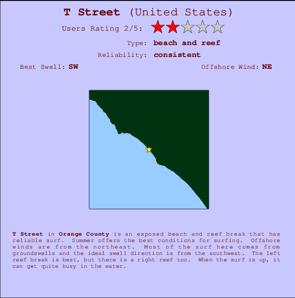
T Street Surf Guide
T Street in Orange County is an exposed beach and reef break that has reliable surf. Summer offers the best conditions for surfing. Offshore winds are from the northeast. Clean groundswells prevail and the best swell direction is from the southwest. Right and better left hand reef breaks.. It's sometimes crowded here. Hazards include .
T Street Spot Info
| Type: | Rating: | Reliability: | Todays Sea Temp*: |
|---|---|---|---|
| consistent | 21.0°C*ocean temperature recorded from satellite |
Surfing T Street:
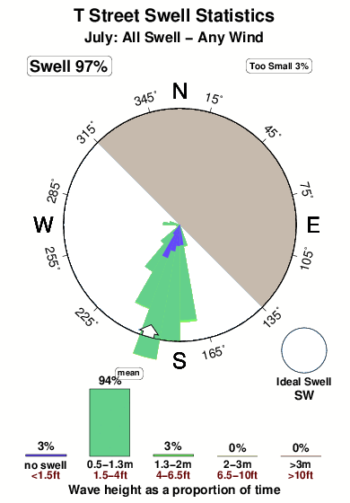
The best conditions reported for surf at T Street occur when a Southwest swell combines with an offshore wind direction from the Northeast.

Voorspelde Golfenergie (Kracht): 12 uur


T Street Surf:
Wednesday, 15 July 2026, 00:50 Local time| Tue | Wed | |||
| 8PM | 11PM | 2AM | 5AM | |
| Wave (m) | ||||
| Periode (s) | 18 | 18 | 18 | 18 |
| Wind (km/h) | ||||
| Wind | cross- on |
glass | glass | cross- on |
- /breaks/T-Street/forecasts/latest
T Street Surf Guide
T Street in Orange County is an exposed beach and reef break that has reliable surf. Summer offers the best conditions for surfing. Offshore winds are from the northeast. Clean groundswells prevail and the best swell direction is from the southwest. Right and better left hand reef breaks.. It's sometimes crowded here. Hazards include .
T Street Spot Info
Type: Rating: Reliability: Todays Sea Temp*:  Beach and reef
 2
2consistent 21.0°C*ocean temperature recorded from satelliteSurfing T Street:
The best conditions reported for surf at T Street occur when a Southwest swell combines with an offshore wind direction from the Northeast.
Voorspelde Golfenergie (Kracht): 12 uur
Gebruik de tabbladen hierboven om de zeewatertemperatuur bij T Street te bekijken, foto's van T Street, T Street gedetailleerde golfvoorspellingen, wind- en weersvoorspellingen, T Street webcams, actuele wind in CAL - Orange County live weerstations en T Street getijdenvoorspellingen. De link van United States golfkaarten opent een grote afbeelding van United States en de omliggende zeeën. Deze golfkaarten kunnen worden dynamisch gemaakt worden met de verschillende golfcomponenten, golfenergie, golfperiode, golfhoogte, samen met de wind en weersvoorspellingen, het actuele weer en de zeetoestand volgens golfboeien uit United States, langskomende schepen en weerstations op de kust. Elk voorspelling pagina's voor dit surfstrand zijn voorzien van een wereldwijde en regionale golfzoeker om de beste surfsomstandigheden in het gebied rond T Street te vinden.
T Street Surf:
Wednesday, 15 July 2026, 00:50 Local timeTue Wed 8PM 11PM 2AM 5AM Wave (m) Periode (s) 18 18 18 18 Wind (km/h) Wind cross-
onglass glass cross-
on- /breaks/T-Street/forecasts/latest
- /breaks/T-Street/forecasts/latest/six_day
T Street Surf Guide
T Street in Orange County is an exposed beach and reef break that has reliable surf. Summer offers the best conditions for surfing. Offshore winds are from the northeast. Clean groundswells prevail and the best swell direction is from the southwest. Right and better left hand reef breaks.. It's sometimes crowded here. Hazards include .
T Street Spot Info
Type: Rating: Reliability: Todays Sea Temp*: Beach and reef2consistent 21.0°C*ocean temperature recorded from satelliteSurfing T Street:
The best conditions reported for surf at T Street occur when a Southwest swell combines with an offshore wind direction from the Northeast.
Voorspelde Golfenergie (Kracht): 12 uur
Gebruik de tabbladen hierboven om de zeewatertemperatuur bij T Street te bekijken, foto's van T Street, T Street gedetailleerde golfvoorspellingen, wind- en weersvoorspellingen, T Street webcams, actuele wind in CAL - Orange County live weerstations en T Street getijdenvoorspellingen. De link van United States golfkaarten opent een grote afbeelding van United States en de omliggende zeeën. Deze golfkaarten kunnen worden dynamisch gemaakt worden met de verschillende golfcomponenten, golfenergie, golfperiode, golfhoogte, samen met de wind en weersvoorspellingen, het actuele weer en de zeetoestand volgens golfboeien uit United States, langskomende schepen en weerstations op de kust. Elk voorspelling pagina's voor dit surfstrand zijn voorzien van een wereldwijde en regionale golfzoeker om de beste surfsomstandigheden in het gebied rond T Street te vinden.
T Street Surf:
Wednesday, 15 July 2026, 00:50 Local timeTue Wed 8PM 11PM 2AM 5AM Wave (m) Periode (s) 18 18 18 18 Wind (km/h) Wind cross-
onglass glass cross-
on- /breaks/T-Street/forecasts/latest
T Street Surf Guide
T Street in Orange County is an exposed beach and reef break that has reliable surf. Summer offers the best conditions for surfing. Offshore winds are from the northeast. Clean groundswells prevail and the best swell direction is from the southwest. Right and better left hand reef breaks.. It's sometimes crowded here. Hazards include .
T Street Spot Info
Type: Rating: Reliability: Todays Sea Temp*: Beach and reef2consistent 21.0°C*ocean temperature recorded from satelliteSurfing T Street:
The best conditions reported for surf at T Street occur when a Southwest swell combines with an offshore wind direction from the Northeast.
Voorspelde Golfenergie (Kracht): 12 uur
Gebruik de tabbladen hierboven om de zeewatertemperatuur bij T Street te bekijken, foto's van T Street, T Street gedetailleerde golfvoorspellingen, wind- en weersvoorspellingen, T Street webcams, actuele wind in CAL - Orange County live weerstations en T Street getijdenvoorspellingen. De link van United States golfkaarten opent een grote afbeelding van United States en de omliggende zeeën. Deze golfkaarten kunnen worden dynamisch gemaakt worden met de verschillende golfcomponenten, golfenergie, golfperiode, golfhoogte, samen met de wind en weersvoorspellingen, het actuele weer en de zeetoestand volgens golfboeien uit United States, langskomende schepen en weerstations op de kust. Elk voorspelling pagina's voor dit surfstrand zijn voorzien van een wereldwijde en regionale golfzoeker om de beste surfsomstandigheden in het gebied rond T Street te vinden.
T Street Surf:
Wednesday, 15 July 2026, 00:50 Local timeTue Wed 8PM 11PM 2AM 5AM Wave (m) Periode (s) 18 18 18 18 Wind (km/h) Wind cross-
onglass glass cross-
onTide Times:
Voor San Clemente, California, %{dist} %{km} van %{location}.
VOLGENDE IS OM (lokale tijd) resterende tijd hoog water laag water T Street Tide Times and Tide Chart
Live Weather:
At BUOY-46285, 6 km from T Street.
- Air temperature
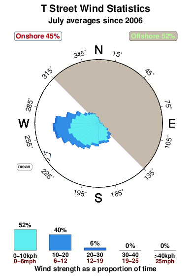
-°COverall T Street Surf Consistency and Wind Distribution in July
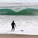
surffoto's uit
de galerijContourlijnen: Wegen & Rivieren: Kies een surflokatie uit het menu 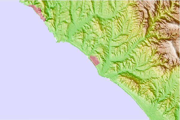
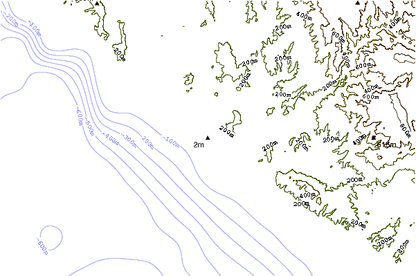
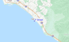
Gebruik deze reliëfkaart om naar de surfspots en de getijdenstations van CAL - Orange County toe te gaan, in de buurt van T Street.
Andere Dichtbijzijnde Surflocaties van T Street:
(klik op locatienaam voor meer informatie)- Closest Locatie0 mi
- Second closest Locatie1 mi
- Third closest Locatie1 mi
- Fourth closest Locatie2 mi
- Fifth closest Locatie2 mi
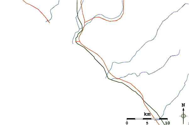
Dichtstbijzijnde golfboeien bij T Street:
- Closest golfboei17 mi
- Second closest golfboei19 mi
- Third closest golfboei34 mi
- Fourth closest golfboei37 mi
- Fifth closest golfboei39 mi
Getijdenstations in de buurt van T Street:
- Closest getijdenstationSan Clemente1 mi
- Second closest getijdenstationDana Point6 mi
- Third closest getijdenstationLaguna Niguel9 mi
- Fourth closest getijdenstationLaguna Beach12 mi
- Fifth closest getijdenstationBalboa Pier, Newport Beach20 mi
Airports
- The closest passenger airport to T Street is John Wayne Arpt Orange Co (Santa Ana) Airport (SNA) in USA, 36 km (22 miles) away (directly).
- The second nearest airport to T Street is Tustin Mcaf Airport (NTK), also in USA, 37 km (23 miles) away.
- Third is March Arb (Riverside) Airport (RIV) in USA, 61 km (38 miles) away.
- Riverside Muni Airport (RAL) in USA is 62 km (39 miles) away.
- Long Beach Airport (LGB), also in USA is the fifth nearest airport to T Street and is 66 km (41 miles) away.
- /breaks/T-Street/forecasts/latest


 Nearest