

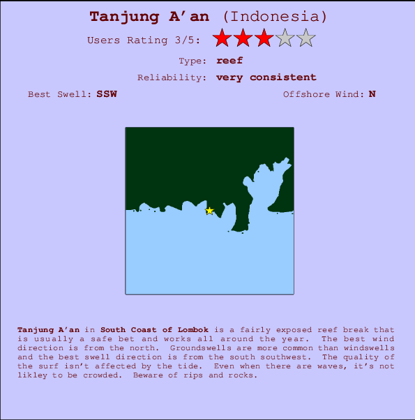
Tanjung A'an Surf Guide
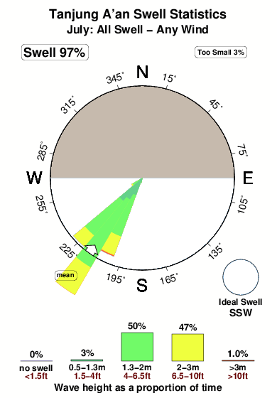
Tanjung A'an in South Lombok is a fairly exposed reef break that has very consistent surf and works all around the year. Offshore winds are from the north. Most of the surf here comes from groundswells and the best swell direction is from the south southwest. A right hand reef. The quality of the surf isn't affected by the tide. Even when there are waves, it's not likley to be crowded. Hazards include rips and rocks.
Tanjung A'an Spot Info
| Type: | Rating: | Reliability: | Todays Sea Temp*: |
|---|---|---|---|
| very consistent | 27.1°C*ocean temperature recorded from satellite |
Surfing Tanjung A'an:
The best conditions reported for surf at Tanjung A'an occur when a South-southwest swell combines with an offshore wind direction from the North.

Voorspelde Golfenergie (Kracht): 12 uur


Tanjung A'an Surf:
Thursday, 16 July 2026, 07:24 Local time| Thursday 16 | ||||
| 5AM | 8AM | 11AM | 2PM | |
| Wave (m) | ||||
| Periode (s) | 15 | 15 | 15 | 15 |
| Wind (km/h) | ||||
| Wind | cross | cross- on |
cross- on |
cross- on |
- /breaks/Tanjung-Aan/forecasts/latest
Tanjung A'an Surf Guide
Tanjung A'an in South Lombok is a fairly exposed reef break that has very consistent surf and works all around the year. Offshore winds are from the north. Most of the surf here comes from groundswells and the best swell direction is from the south southwest. A right hand reef. The quality of the surf isn't affected by the tide. Even when there are waves, it's not likley to be crowded. Hazards include rips and rocks.
Tanjung A'an Spot Info
Type: Rating: Reliability: Todays Sea Temp*:  Reef
Reef 3
3very consistent 27.1°C*ocean temperature recorded from satelliteSurfing Tanjung A'an:
The best conditions reported for surf at Tanjung A'an occur when a South-southwest swell combines with an offshore wind direction from the North.
Voorspelde Golfenergie (Kracht): 12 uur
Gebruik de tabbladen hierboven om de zeewatertemperatuur bij Tanjung A'an te bekijken, foto's van Tanjung A'an, Tanjung A'an gedetailleerde golfvoorspellingen, wind- en weersvoorspellingen, Tanjung A'an webcams, actuele wind in Lombok - South live weerstations en Tanjung A'an getijdenvoorspellingen. De link van Indonesia golfkaarten opent een grote afbeelding van Indonesia en de omliggende zeeën. Deze golfkaarten kunnen worden dynamisch gemaakt worden met de verschillende golfcomponenten, golfenergie, golfperiode, golfhoogte, samen met de wind en weersvoorspellingen, het actuele weer en de zeetoestand volgens golfboeien uit Indonesia, langskomende schepen en weerstations op de kust. Elk voorspelling pagina's voor dit surfstrand zijn voorzien van een wereldwijde en regionale golfzoeker om de beste surfsomstandigheden in het gebied rond Tanjung A'an te vinden.
Tanjung A'an Surf:
Thursday, 16 July 2026, 07:24 Local timeThursday 16 5AM 8AM 11AM 2PM Wave (m) Periode (s) 15 15 15 15 Wind (km/h) Wind cross cross-
oncross-
oncross-
on- /breaks/Tanjung-Aan/forecasts/latest
- /breaks/Tanjung-Aan/forecasts/latest/six_day
Tanjung A'an Surf Guide
Tanjung A'an in South Lombok is a fairly exposed reef break that has very consistent surf and works all around the year. Offshore winds are from the north. Most of the surf here comes from groundswells and the best swell direction is from the south southwest. A right hand reef. The quality of the surf isn't affected by the tide. Even when there are waves, it's not likley to be crowded. Hazards include rips and rocks.
Tanjung A'an Spot Info
Type: Rating: Reliability: Todays Sea Temp*: Reef3very consistent 27.1°C*ocean temperature recorded from satelliteSurfing Tanjung A'an:
The best conditions reported for surf at Tanjung A'an occur when a South-southwest swell combines with an offshore wind direction from the North.
Voorspelde Golfenergie (Kracht): 12 uur
Gebruik de tabbladen hierboven om de zeewatertemperatuur bij Tanjung A'an te bekijken, foto's van Tanjung A'an, Tanjung A'an gedetailleerde golfvoorspellingen, wind- en weersvoorspellingen, Tanjung A'an webcams, actuele wind in Lombok - South live weerstations en Tanjung A'an getijdenvoorspellingen. De link van Indonesia golfkaarten opent een grote afbeelding van Indonesia en de omliggende zeeën. Deze golfkaarten kunnen worden dynamisch gemaakt worden met de verschillende golfcomponenten, golfenergie, golfperiode, golfhoogte, samen met de wind en weersvoorspellingen, het actuele weer en de zeetoestand volgens golfboeien uit Indonesia, langskomende schepen en weerstations op de kust. Elk voorspelling pagina's voor dit surfstrand zijn voorzien van een wereldwijde en regionale golfzoeker om de beste surfsomstandigheden in het gebied rond Tanjung A'an te vinden.
Tanjung A'an Surf:
Thursday, 16 July 2026, 07:24 Local timeThursday 16 5AM 8AM 11AM 2PM Wave (m) Periode (s) 15 15 15 15 Wind (km/h) Wind cross cross-
oncross-
oncross-
on- /breaks/Tanjung-Aan/forecasts/latest
Tanjung A'an Surf Guide
Tanjung A'an in South Lombok is a fairly exposed reef break that has very consistent surf and works all around the year. Offshore winds are from the north. Most of the surf here comes from groundswells and the best swell direction is from the south southwest. A right hand reef. The quality of the surf isn't affected by the tide. Even when there are waves, it's not likley to be crowded. Hazards include rips and rocks.
Tanjung A'an Spot Info
Type: Rating: Reliability: Todays Sea Temp*: Reef3very consistent 27.1°C*ocean temperature recorded from satelliteSurfing Tanjung A'an:
The best conditions reported for surf at Tanjung A'an occur when a South-southwest swell combines with an offshore wind direction from the North.
Voorspelde Golfenergie (Kracht): 12 uur
Gebruik de tabbladen hierboven om de zeewatertemperatuur bij Tanjung A'an te bekijken, foto's van Tanjung A'an, Tanjung A'an gedetailleerde golfvoorspellingen, wind- en weersvoorspellingen, Tanjung A'an webcams, actuele wind in Lombok - South live weerstations en Tanjung A'an getijdenvoorspellingen. De link van Indonesia golfkaarten opent een grote afbeelding van Indonesia en de omliggende zeeën. Deze golfkaarten kunnen worden dynamisch gemaakt worden met de verschillende golfcomponenten, golfenergie, golfperiode, golfhoogte, samen met de wind en weersvoorspellingen, het actuele weer en de zeetoestand volgens golfboeien uit Indonesia, langskomende schepen en weerstations op de kust. Elk voorspelling pagina's voor dit surfstrand zijn voorzien van een wereldwijde en regionale golfzoeker om de beste surfsomstandigheden in het gebied rond Tanjung A'an te vinden.
Tanjung A'an Surf:
Thursday, 16 July 2026, 07:24 Local timeThursday 16 5AM 8AM 11AM 2PM Wave (m) Periode (s) 15 15 15 15 Wind (km/h) Wind cross cross-
oncross-
oncross-
onTide Times:
Voor Aan, %{dist} %{km} van %{location}.
VOLGENDE IS OM (lokale tijd) resterende tijd hoog water laag water Tanjung A'an Tide Times and Tide Chart
Live Weather:
At Bandara Airport, 20 km from Tanjung A'an.
calm
(km/h)Air temperature
24°COverall Tanjung A'an Surf Consistency and Wind Distribution in July


Wind stats for Tanjung A'an: see the variation in direction and stength by month.
surffoto's uit
de galerijContourlijnen: Wegen & Rivieren: Kies een surflokatie uit het menu 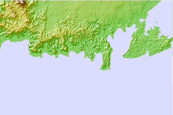
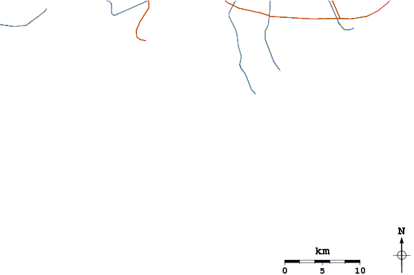
Gebruik deze reliëfkaart om naar de surfspots en de getijdenstations van Lombok - South toe te gaan, in de buurt van Tanjung A'an.
Andere Dichtbijzijnde Surflocaties van Tanjung A'an:
(klik op locatienaam voor meer informatie)- Closest Locatie2 mi
- Second closest Locatie2 mi
- Third closest Locatie2 mi
- Fourth closest Locatie2 mi
- Fifth closest Locatie3 mi
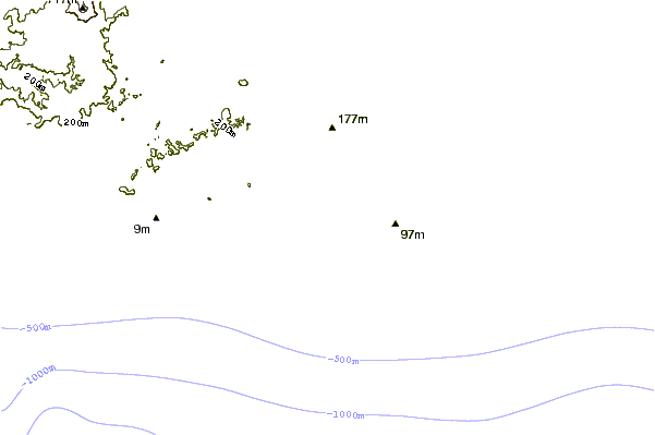
Dichtstbijzijnde golfboeien bij Tanjung A'an:
- Closest golfboei1740 mi
- Second closest golfboei2050 mi
- Third closest golfboei2175 mi
- Fourth closest golfboei2253 mi
- Fifth closest golfboei2270 mi
Getijdenstations in de buurt van Tanjung A'an:
- Closest getijdenstationMataram27 mi
- Second closest getijdenstationDenpasar78 mi
- Third closest getijdenstationSumbawa Besar81 mi
- Fourth closest getijdenstationSingaraja101 mi
- Fifth closest getijdenstationBanjar106 mi
Airports
- The closest passenger airport to Tanjung A'an is Selaparang (Mataram) Airport (AMI) in Indonesia, which is 48 km (30 miles) away (directly).
- The second nearest airport to Tanjung A'an is Bali International (Denpasar) Airport (DPS), also in Indonesia, 129 km (80 miles) away.
- The third closest airport is Sumbawa Besar Airport (SWG), also in Indonesia, 129 km (80 miles) away.
- /breaks/Tanjung-Aan/forecasts/latest

 Nearest