
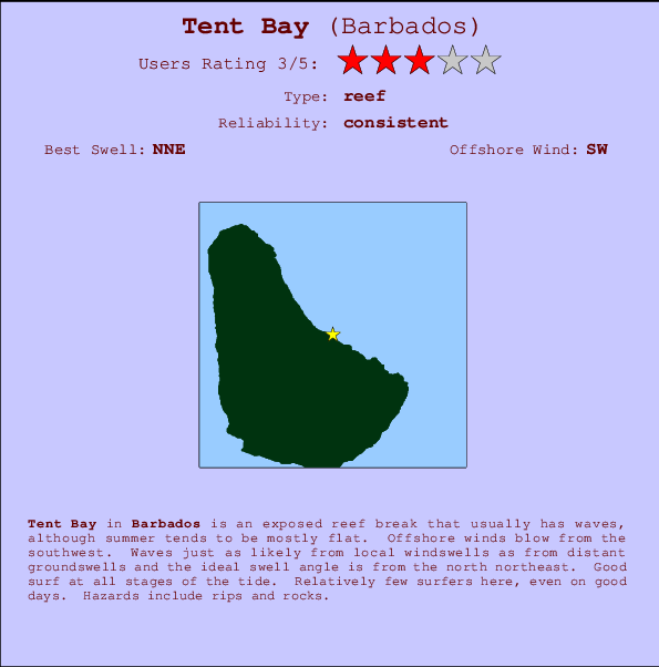
Tent Bay Surf Guide
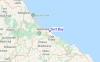
Tent Bay on the East Coast is an exposed reef break that usually has waves, although summer tends to be mostly flat. The best wind direction is from the southwest. Tends to receive a mix of groundswells and windswells and the ideal swell angle is from the north northeast. A left hand reef. Good surf at all stages of the tide. Rarely crowded here. Take care of rips and rocks.
Tent Bay Spot Info
| Type: | Rating: | Reliability: | Todays Sea Temp*: |
|---|---|---|---|
| consistent | 28.0°C*ocean temperature recorded from satellite |
Surfing Tent Bay:
The best conditions reported for surf at Tent Bay occur when a North-northeast swell combines with an offshore wind direction from the Southwest.

Voorspelde Golfenergie (Kracht): 12 uur


Tent Bay Surf:
Tuesday, 21 July 2026, 04:43 Local time| Tuesday 21 | ||||
| 5AM | 8AM | 11AM | 2PM | |
| Wave (m) | ||||
| Periode (s) | 7 | 7 | 7 | 7 |
| Wind (km/h) | ||||
| Wind | cross- on |
cross- on |
cross- on |
cross- on |
- /breaks/Tent-Bay/forecasts/latest
Tent Bay Surf Guide
Tent Bay on the East Coast is an exposed reef break that usually has waves, although summer tends to be mostly flat. The best wind direction is from the southwest. Tends to receive a mix of groundswells and windswells and the ideal swell angle is from the north northeast. A left hand reef. Good surf at all stages of the tide. Rarely crowded here. Take care of rips and rocks.
Tent Bay Spot Info
Type: Rating: Reliability: Todays Sea Temp*:  Reef
Reef 3
3consistent 28.0°C*ocean temperature recorded from satelliteSurfing Tent Bay:
The best conditions reported for surf at Tent Bay occur when a North-northeast swell combines with an offshore wind direction from the Southwest.
Voorspelde Golfenergie (Kracht): 12 uur
Gebruik de tabbladen hierboven om de zeewatertemperatuur bij Tent Bay te bekijken, foto's van Tent Bay, Tent Bay gedetailleerde golfvoorspellingen, wind- en weersvoorspellingen, Tent Bay webcams, actuele wind in Barbados live weerstations en Tent Bay getijdenvoorspellingen. De link van Barbados golfkaarten opent een grote afbeelding van Barbados en de omliggende zeeën. Deze golfkaarten kunnen worden dynamisch gemaakt worden met de verschillende golfcomponenten, golfenergie, golfperiode, golfhoogte, samen met de wind en weersvoorspellingen, het actuele weer en de zeetoestand volgens golfboeien uit Barbados, langskomende schepen en weerstations op de kust. Elk voorspelling pagina's voor dit surfstrand zijn voorzien van een wereldwijde en regionale golfzoeker om de beste surfsomstandigheden in het gebied rond Tent Bay te vinden.
Tent Bay Surf:
Tuesday, 21 July 2026, 04:43 Local timeTuesday 21 5AM 8AM 11AM 2PM Wave (m) Periode (s) 7 7 7 7 Wind (km/h) Wind cross-
oncross-
oncross-
oncross-
on- /breaks/Tent-Bay/forecasts/latest
- /breaks/Tent-Bay/forecasts/latest/six_day
Tent Bay Surf Guide
Tent Bay on the East Coast is an exposed reef break that usually has waves, although summer tends to be mostly flat. The best wind direction is from the southwest. Tends to receive a mix of groundswells and windswells and the ideal swell angle is from the north northeast. A left hand reef. Good surf at all stages of the tide. Rarely crowded here. Take care of rips and rocks.
Tent Bay Spot Info
Type: Rating: Reliability: Todays Sea Temp*: Reef3consistent 28.0°C*ocean temperature recorded from satelliteSurfing Tent Bay:
The best conditions reported for surf at Tent Bay occur when a North-northeast swell combines with an offshore wind direction from the Southwest.
Voorspelde Golfenergie (Kracht): 12 uur
Gebruik de tabbladen hierboven om de zeewatertemperatuur bij Tent Bay te bekijken, foto's van Tent Bay, Tent Bay gedetailleerde golfvoorspellingen, wind- en weersvoorspellingen, Tent Bay webcams, actuele wind in Barbados live weerstations en Tent Bay getijdenvoorspellingen. De link van Barbados golfkaarten opent een grote afbeelding van Barbados en de omliggende zeeën. Deze golfkaarten kunnen worden dynamisch gemaakt worden met de verschillende golfcomponenten, golfenergie, golfperiode, golfhoogte, samen met de wind en weersvoorspellingen, het actuele weer en de zeetoestand volgens golfboeien uit Barbados, langskomende schepen en weerstations op de kust. Elk voorspelling pagina's voor dit surfstrand zijn voorzien van een wereldwijde en regionale golfzoeker om de beste surfsomstandigheden in het gebied rond Tent Bay te vinden.
Tent Bay Surf:
Tuesday, 21 July 2026, 04:43 Local timeTuesday 21 5AM 8AM 11AM 2PM Wave (m) Periode (s) 7 7 7 7 Wind (km/h) Wind cross-
oncross-
oncross-
oncross-
on- /breaks/Tent-Bay/forecasts/latest
Tent Bay Surf Guide
Tent Bay on the East Coast is an exposed reef break that usually has waves, although summer tends to be mostly flat. The best wind direction is from the southwest. Tends to receive a mix of groundswells and windswells and the ideal swell angle is from the north northeast. A left hand reef. Good surf at all stages of the tide. Rarely crowded here. Take care of rips and rocks.
Tent Bay Spot Info
Type: Rating: Reliability: Todays Sea Temp*: Reef3consistent 28.0°C*ocean temperature recorded from satelliteSurfing Tent Bay:
The best conditions reported for surf at Tent Bay occur when a North-northeast swell combines with an offshore wind direction from the Southwest.
Voorspelde Golfenergie (Kracht): 12 uur
Gebruik de tabbladen hierboven om de zeewatertemperatuur bij Tent Bay te bekijken, foto's van Tent Bay, Tent Bay gedetailleerde golfvoorspellingen, wind- en weersvoorspellingen, Tent Bay webcams, actuele wind in Barbados live weerstations en Tent Bay getijdenvoorspellingen. De link van Barbados golfkaarten opent een grote afbeelding van Barbados en de omliggende zeeën. Deze golfkaarten kunnen worden dynamisch gemaakt worden met de verschillende golfcomponenten, golfenergie, golfperiode, golfhoogte, samen met de wind en weersvoorspellingen, het actuele weer en de zeetoestand volgens golfboeien uit Barbados, langskomende schepen en weerstations op de kust. Elk voorspelling pagina's voor dit surfstrand zijn voorzien van een wereldwijde en regionale golfzoeker om de beste surfsomstandigheden in het gebied rond Tent Bay te vinden.
Tent Bay Surf:
Tuesday, 21 July 2026, 04:43 Local timeTuesday 21 5AM 8AM 11AM 2PM Wave (m) Periode (s) 7 7 7 7 Wind (km/h) Wind cross-
oncross-
oncross-
oncross-
onTide Times:
Voor Barclays, %{dist} %{km} van %{location}.
VOLGENDE IS OM (lokale tijd) resterende tijd hoog water laag water Tent Bay Tide Times and Tide Chart
Live Weather:
At Grantley Adams International Airport, 16 km from Tent Bay.
light winds from the ENE
(km/h)
Dry and partly cloudyAir temperature
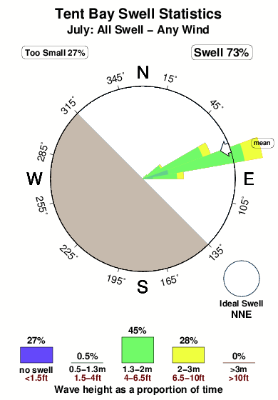
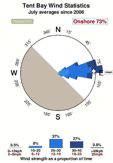
26°COverall Tent Bay Surf Consistency and Wind Distribution in July
surffoto's uit
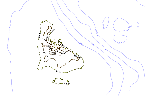
de galerijContourlijnen: Wegen & Rivieren: Kies een surflokatie uit het menu 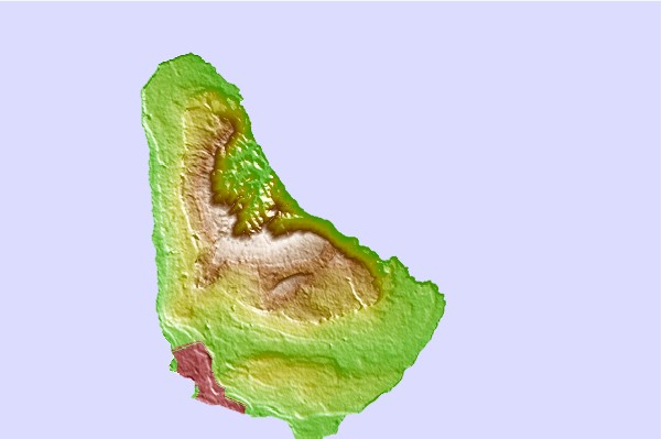
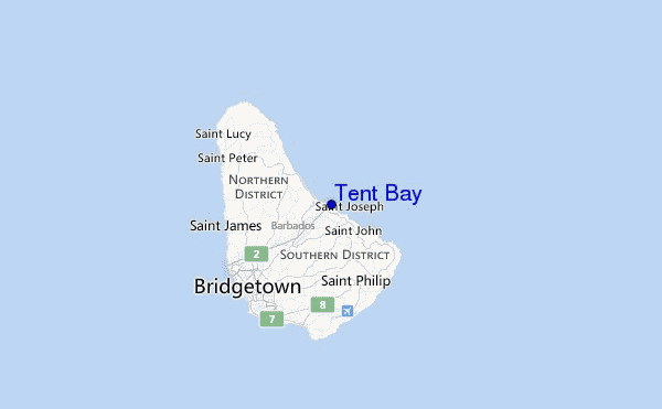
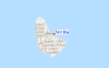
Gebruik deze reliëfkaart om naar de surfspots en de getijdenstations van Barbados toe te gaan, in de buurt van Tent Bay.
Andere Dichtbijzijnde Surflocaties van Tent Bay:
(klik op locatienaam voor meer informatie)- Closest Locatie0 mi
- Second closest Locatie1 mi
- Third closest Locatie1 mi
- Fourth closest Locatie1 mi
- Fifth closest Locatie1 mi
Dichtstbijzijnde golfboeien bij Tent Bay:
- Closest golfboei242 mi
- Second closest golfboei351 mi
- Third closest golfboei445 mi
- Fourth closest golfboei493 mi
- Fifth closest golfboei528 mi
Getijdenstations in de buurt van Tent Bay:
- Closest getijdenstationBridgetown, Barbados11 mi
- Second closest getijdenstationVieux Fort Bay104 mi
- Third closest getijdenstationLe Robert110 mi
- Fourth closest getijdenstationBisee112 mi
- Fifth closest getijdenstationKingstown, Saint Vincent115 mi
Airports
- The closest passenger airport to Tent Bay is Grantley Adams International (Bridgetown) Airport (BGI) in Barbados, 15 km (9 miles) away (directly).
- The second nearest airport to Tent Bay is Hewanorra International (Hewandorra) Airport (UVF) in St. Lucia Island, 167 km (104 miles) away.
- Third is George F L Charles (Castries) Airport (SLU) in St. Lucia Island, 184 km (114 miles) away.
- Mustique Airport (MQS) in St.vincent/grenadines is 185 km (115 miles) away.
- E T Joshua (Kingstown) Airport (SVD), also in St.vincent/grenadines is the fifth nearest airport to Tent Bay and is 185 km (115 miles) away.
- /breaks/Tent-Bay/forecasts/latest


 Nearest